地震地质 ›› 2020, Vol. 42 ›› Issue (1): 18-32.DOI: 10.3969/j.issn.0253-4967.2020.01.002
李智敏1,3)( ), 任治坤2,)*(), 刘金瑞2), 哈广浩2), 李正芳2), 王勃1), 王林建3)
收稿日期:2019-10-23
出版日期:2020-02-20
发布日期:2020-06-17
通讯作者:
任治坤
作者简介:〔作者简介〕 李智敏, 男, 1977年生, 2005年于中国地震局兰州地震研究所获构造地质专业硕士学位, 副研究员, 现主要从事活动构造及其次生灾害方面的研究工作, 电话: 0755-82616372, E-mail: minhero_168@126.com。
基金资助:
LI Zhi-min1,3)(), REN Zhi-kun2)(), LIU Jin-rui2), HA Guang-hao2), LI Zheng-fang2), WANG Bo1), WANG Lin-jian3)
Received:2019-10-23
Online:2020-02-20
Published:2020-06-17
摘要:
在青海都兰最新开展的活动断裂调查工作中, 于都兰-茶卡高地南部新发现了1条长约40km、 走向近NEE的左旋走滑、 局部兼正断性质的全新世活动断裂——热水-桃斯托河断裂。 文中通过野外地质调查与典型段落无人机航拍主要获得了以下2点认识: 1)热水-桃斯托河断裂及其全新世活动的发现尚属首次, 其长约40km, 断裂带东端存在长6km的地表破裂带; 2)断裂切过的冲沟和阶地存在左旋位错现象, 利用无人机获取高分辨率DEM影像, 并对冲沟沟谷的地形剖面进行恢复测量得到的位错量为(9.3±0.5)m、 (17.9±1.5)m和(36.8±2)m。 对2级冲沟阶地位错进行恢复测量得到T1/T0阶地陡坎的位错量为(18.2±1.5)m, T2/T1阶地陡坎的位错量为(35.8±2)m, 可以看出冲沟位错量和阶地位错量的结果较为一致。 据历史地震记载, 1938年4月10日在热水-桃斯托河断裂地表破裂的东端发生了M53/4地震, 1952年3月21日发生了MS5.0地震, 可能均与该断裂的活动有关。 但在都兰县县志等相关资料中均未发现有关于这2次地震的文献记录, 这可能与当时地震震中比较偏远、 都兰县人口稀少且发震时间比较久远有关。 东昆仑断裂和鄂拉山断裂最南端会聚形成1个向NW挤出的楔形断块, 位于楔形断块端部的都兰盆地受区域NE-SW向主压应力和2条边界断裂剪切作用的影响, 经历了挤压伴随局部拉张的复杂变形过程。 这主要是由于2条控制楔形断块的边界断裂——东昆仑断裂与鄂拉山断裂之间存在NE-SW向的挤压作用, 在这样的挤压过程中, 楔形断块局部拉张的具体表现形式为两侧断裂发生走滑, 使断块向NW向挤出, 因此该区三角楔形挤出的变形机制与纯粹的刚性块体的挤出机制有所不同。 在靠近鄂拉山断裂的都兰盆地东北缘形成一系列向SE会聚的羽列状逆冲断裂, 其形态上向E与鄂拉山断裂平行, 可能在深部汇入鄂拉山断裂; 靠近东昆仑断裂带的都兰盆地南缘断裂, 即热水-桃斯托河断裂受到东昆仑左旋走滑断裂和鄂拉山右旋走滑断裂共同作用的影响, 表现为左旋走滑的活动特征, 同时楔形断块向NW挤出, 使其东南端出现局部拉张, 故断层局部又表现为拉张性质。 这些断裂共同吸收或转换高原东北缘的剪切应力。 因此, 此次对都兰热水-桃斯托河断裂的新发现为更好地认识和理解青藏高原东北部断块内部的变形方式和机制等提供了重要的约束条件和依据。
中图分类号:
李智敏, 任治坤, 刘金瑞, 哈广浩, 李正芳, 王勃, 王林建. 青海都兰热水-桃斯托河断裂的新发现及构造意义[J]. 地震地质, 2020, 42(1): 18-32.
LI Zhi-min, REN Zhi-kun, LIU Jin-rui, HA Guang-hao, LI Zheng-fang, WANG Bo, WANG Lin-jian. NEW DISCOVERY OF RESHUI-TAOSTUO RIVER FAULT IN DULAN, QINGHAI PROVINCE AND ITS IMPLICATIONS[J]. SEISMOLOGY AND GEOLOGY, 2020, 42(1): 18-32.
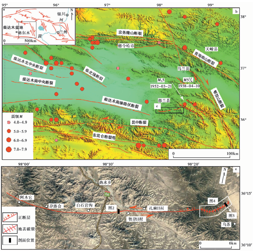
图 1 研究区区域地震构造图
Fig. 1 Seismotectonic map of the study area.
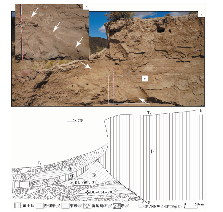
图 2 智尕日村西断层剖面
Fig. 2 Fault section at west of Zhigari village.
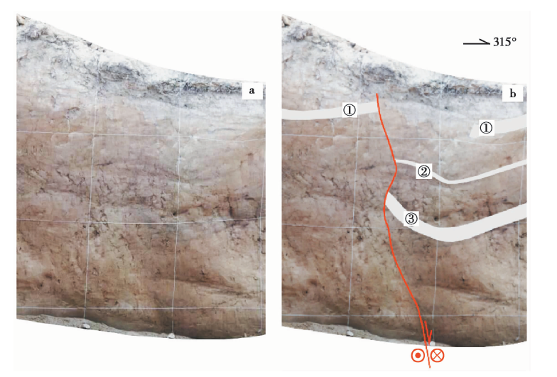
图 3 桃斯托河以西断层剖面灰色条带为断层断错标志层
Fig. 3 Fault section west of Taostuo River.
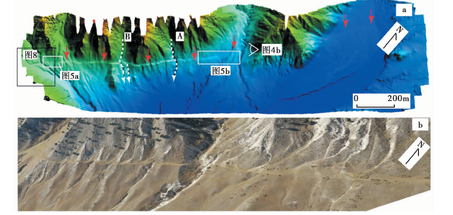
图 4 热水-桃斯托断裂西端地表破裂a 无人机DEM地貌图; b 无人机斜射地貌图
Fig. 4 Surface rupture at western end of Reshui-Taostuo River Fault.
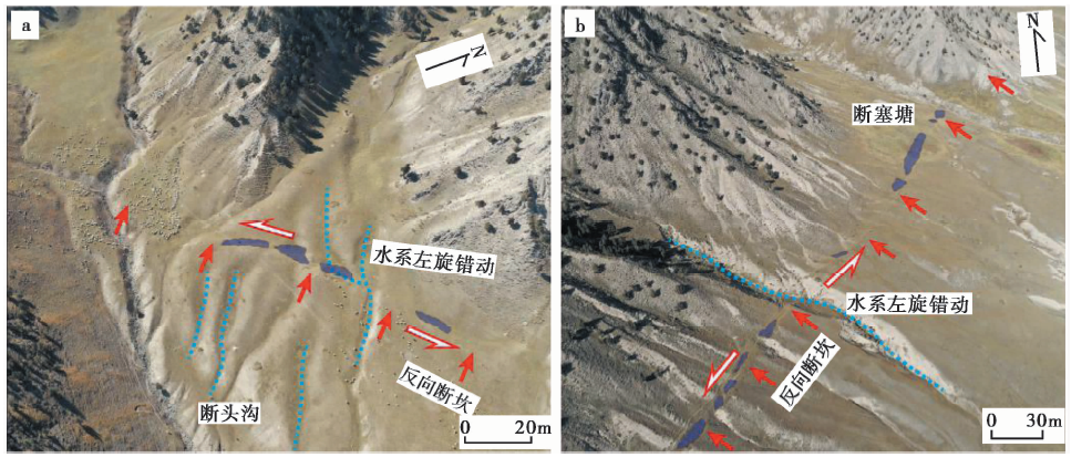
图 5 沿着地表破裂发育的断塞塘
Fig. 5 Sag ponds developed along the surface rupture.
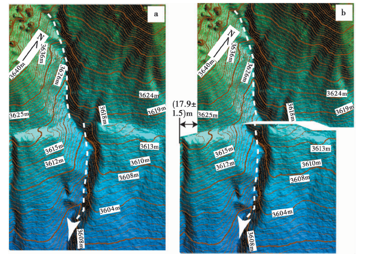
图 6 冲沟A左旋位错图及其恢复图a 原始地貌图; b 1次位错恢复图
Fig. 6 Left-lateral offset of gully A and its recovery.
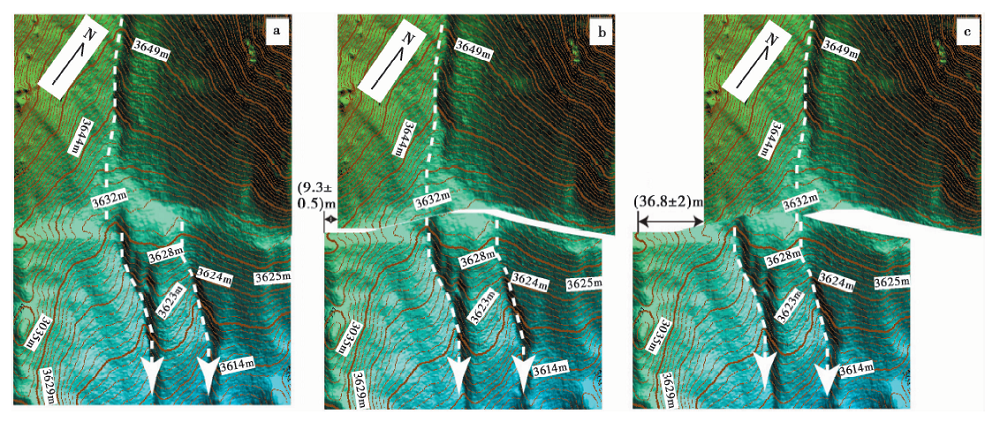
图 7 冲沟B左旋位错图及其恢复图a 原始地貌图; b 1次位错恢复图; c 2次位错恢复图
Fig. 7 Left-lateral offset of gully B and its recovery.

图 8 断错地貌解译及位错恢复图a 原始地貌图; b 断错地貌解译图; c T1阶地位错恢复图; d T2阶地位错恢复图
Fig. 8 Interpretation of fault geomorphology and its recovery.
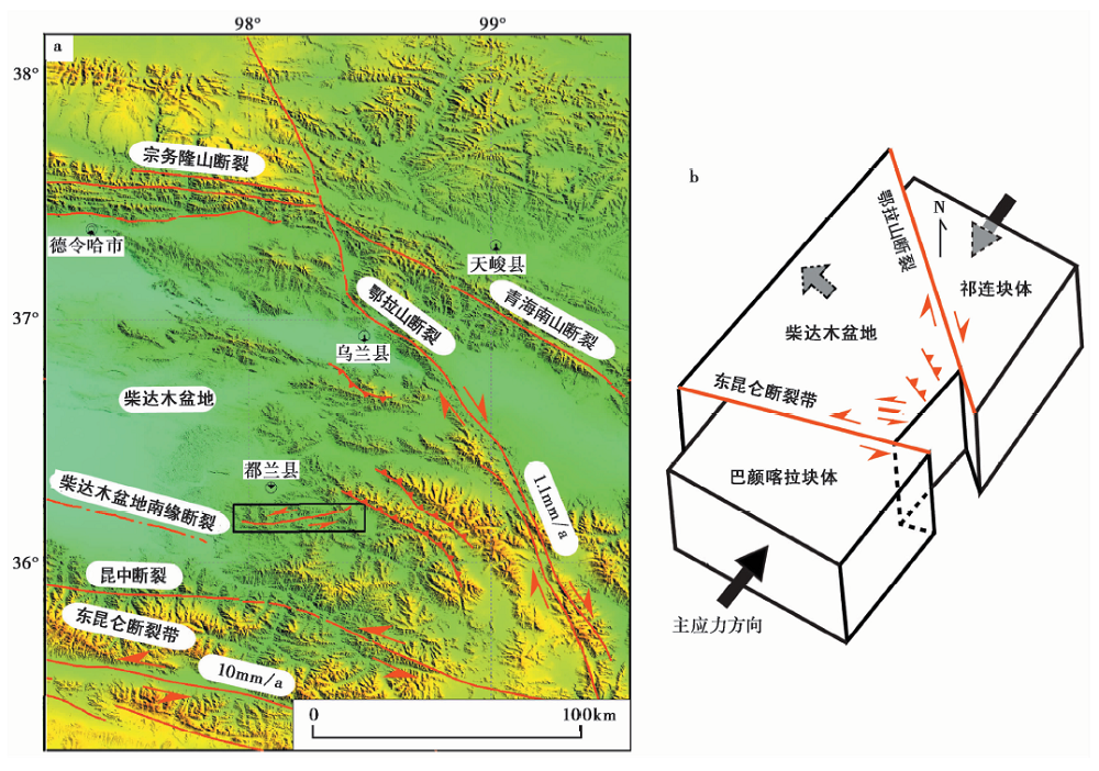
图9 研究区主要活动断层分布及其滑动速率(a)及热水-桃斯托河断裂成因机制(b)
Fig. 9 Major active faults and corresponding slip rates(a)and formation mechanism of Reshui-Taostuo River Fault(b).
| [1] | 邓起东, 陈立春, 冉勇康. 2004. 活动构造定量研究与应用[J]. 地学前缘, 11(4): 383—392. |
| DENG Qi-dong, CHEN Li-chun, RAN Yong-kang.2004. Quantitative studies and applications of active tectonics[J]. Earth Science Frontiers, 11(4): 383—392(in Chinese). | |
| [2] | 邓起东, 闻学泽. 2008. 活动构造研究: 历史、 进展与建议[J]. 地震地质, 30(1): 1—30. |
| DENG Qi-dong, WEN Xue-ze.2008. A review on the research of active tectonics: History, progress and suggestions[J]. Seismology and Geology, 30(1): 1—30(in Chinese). | |
| [3] | 邓起东, 张培震, 冉勇康, 等. 2002. 中国活动构造基本特征[J]. 中国科学(D辑), 32(12): 1020—1030. |
| DENG Qi-dong, ZHANG Pei-zhen, RAN Yong-kang, et al.2002. Basic characteristic of active tectonics of China[J]. Science in China(Ser D), 32(12): 1020—1030(in Chinese). | |
| [4] | 付碧宏, 张松林, 谢小平, 等. 2006. 阿尔金断裂系西段——康西瓦断裂的晚第四纪构造地貌特征研究[J]. 第四纪研究, 26(2): 228—235. |
| FU Bi-hong, ZHANG Song-lin, XIE Xiao-ping, et al.2006. Late Quaternary tectono-geomorphic features along the Kangxiwar Fault, Altyn Tagh fault system, northern Tibet[J]. Quaternary Sciences, 26(2): 228—235(in Chinese). | |
| [5] | 李陈侠, 徐锡伟, 闻学泽, 等. 2011. 东昆仑断裂带中东部地震破裂分段性与走滑运动分解作用[J]. 中国科学(D辑), 41(9): 1295—1310. |
| LI Chen-xia, XU Xi-wei, WEN Xue-ze, et al.2011. Rupture segmentation and slip partitioning of the mid-eastern part of the Kunlun Fault, north Tibetan plateau[J]. Science in China(Ser D), 41(9): 1295—1310(in Chinese). | |
| [6] | 李智敏, 李文巧, 田勤俭, 等. 2013. 青藏高原东北缘热水-日月山断裂带热水段古地震初步研究[J]. 地球物理学进展, 28(4): 1766—1771. |
| LI Zhi-min, LI Wen-qiao, TIAN Qin-jian, et al.2013. A preliminary study on paleo-earthquake of the Reshui segment in Reshui-Riyue Mt. fault zone, Qinghai Province[J]. Progress in Geophysics, 28(4): 1766—1771(in Chinese). | |
| [7] | 李智敏, 李文巧, 殷翔, 等. 2019. 利用构造地貌分析日月山断裂晚更新世以来的演化[J]. 地震地质, 41(5): 781—792. doi: 10.3969/j.issn.0253-4967.2019.05.001. |
| LI Zhi-min, LI Wen-qiao, YIN-xiang, et al.2019. Analysis of the evolution of the Riyueshan Fault since the late Pleistocene using structural geomorphology[J]. Seismology and Geology, 41(5): 781—792(in Chinese). | |
| [8] | 李智敏, 苏鹏, 黄帅堂, 等. 2018. 日月山断裂德州段晚更新世以来的活动速率研究[J]. 地震地质, 40(3): 656—671. doi: 10.3969/j.issn.0253-4967.2018.03.011. |
| LI Zhi-min, SU Peng, HUANG Shuai-tang, et al.2018. Slip rates of the Riyue Mt. Fault at Dezhou segment since late Pleistocene[J]. Seismology and Geology, 40(3): 656—671(in Chinese). | |
| [9] | 青海省地震局, 中国地震局地壳应力研究所. 1999. 东昆仑活动断裂带 [M]. 北京: 地震出版社. |
| Seismological Bureau of Qinghai Province, Institute of Crustal Dynamics of China Earthquake Administration. 1999. The Eastern Kunlun Active Fault Zone [M]. Seismological Press, Beijing(in Chinese). | |
| [10] | 苏鹏, 田勤俭, 梁朋, 等. 2016. 基于青衣江变形河流阶地研究龙门山断裂带南段的构造活动性[J]. 地震地质, 38(3): 523—545. doi: 10.3969/j.issn.0253-4967.2016.03.003. |
| SU Peng, TIAN Qin-jian, LIANG Peng, et al.2016. Using deformed fluvial terraces of the Qingyijiang River to study the tectonic activity of the southern segment of Longmenshan fault zone[J]. Seismology and Geology, 38(3): 523—545(in Chinese). | |
| [11] | 徐锡伟, 于贵华, 陈桂华, 等. 2007. 青藏高原北部大型走滑断裂带近地表地质变形带特征分析[J]. 地震地质, 29(2): 201—217. |
| XU Xi-wei, YU Gui-hua, CHEN Gui-hua, et al.2007. Near-surface character of permanent geologic deformation across the mega-strike-slip faults in the northern Tibetan plateau[J]. Seismology and Geology, 29(2): 201—217(in Chinese). | |
| [12] | 杨顺虎, 付碧宏, 时丕龙. 2012. 东昆仑活动断裂带秀沟盆地段晚第四纪构造变形与地貌特征研究[J]. 第四纪研究, 32(5): 921—930. |
| YANG Shun-hu, FU Bi-hong, SHI Pi-long.2012. Late Quaternary structural deformation and tectono-geomorphic features along the Xiugou Basin segment, eastern Kunlun fault zone[J]. Quaternary Sciences, 32(5): 921—930(in Chinese). | |
| [13] | 袁道阳, 刘小龙, 张培震, 等. 2003a. 青海热水-日月山断裂带古地震的初步研究[J]. 西北地震学报, 25(2): 136—142. |
| YUAN Dao-yang, LIU Xiao-long, ZHANG Pei-zhen, et al.2003a. A preliminary study on palaeo-earthquake events of the Reshui-Riyue Mt. active fault zone in Qinghai Province[J]. Northwestern Seismological Journal, 25(2): 136—142(in Chinese). | |
| [14] | 袁道阳, 刘小龙, 张培震, 等. 2003b. 青海热水-日月山断裂带的新活动特征[J]. 地震地质, 25(1): 155—165. |
| YUAN Dao-yang, LIU Xiao-long, ZHANG Pei-zhen, et al.2003b. Characteristics of the modern activity of the Reshui-Riyueshan fault zone in Qinghai Province[J]. Seismology and Geology, 25(1): 155—165(in Chinese). | |
| [15] | 袁道阳, 张培震, 刘百篪, 等. 2004. 青藏高原东北缘晚第四纪活动构造的几何图像与构造转换[J]. 地质学报, 78(2): 270—278. |
| YUAN Dao-yang, ZHANG Pei-zhen, LIU Bai-chi, et al.2004. Geometrical imagery and tectonic transformation of Late Quaternary active tectonics in northeastern margin of Qinghai-Xizang Plateau[J]. Acta Geologica Sinica, 78(2): 270—278(in Chinese). | |
| [16] | 张培震, 邓起东, 张竹琪, 等. 2013. 中国大陆的活动断裂、 地震灾害及其动力过程[J]. 中国科学(D辑), 43(10): 1607—1620. |
| ZHANG Pei-zhen, DENG Qi-dong, ZHANG Zhu-qi, et al.2013. Active faults, earthquake disasters and their dynamic processes in the mainland of China[J]. Science in China(Ser D), 43(10): 1607—1620(in Chinese). | |
| [17] | 张培震, 王敏, 甘卫军, 等. 2003. GPS 观测的活动断裂滑动速率及其对现今大陆动力作用的制约[J]. 地学前缘, 10(S1): 81—92. |
| ZHANG Pei-zhen, WANG Min, GAN Wei-jun, et al.2003. Slip rates along major active faults from GPS measurements and constraints on contemporary continental tectonics[J]. Earth Science Frontiers, 10(S1): 81—92(in Chinese). | |
| [18] | 张培震, 郑德文, 尹功明, 等. 2006. 有关青藏高原东北缘晚新生代扩展与隆升的讨论[J]. 第四纪研究, 26(1): 5—13. |
| ZHANG Pei-zhen, ZHENG De-wen, YIN Gong-ming, et al.2006. Discussion on late Cenozoic growth and rise of northeastern margin of the Tibetan plateau[J]. Quaternary Sciences, 26(1): 5—13(in Chinese). | |
| [19] | 郑文俊. 2009. 河西走廊及其邻区活动构造图像及构造变形模式 [D]. 北京: 中国地震局地质研究所. |
| ZHENG Wen-jun.2009. Geometric pattern and active tectonics of the Hexi Corridor and its adjacent regions [D]. Institute of Geology, China Earthquake Administration, Beijing(in Chinese). | |
| [20] | 郑文俊, 袁道阳, 张培震, 等. 2016. 青藏高原东北缘活动构造几何图像, 运动转换与高原扩展[J]. 第四纪研究, 36(4): 775—788. |
| ZHENG Wen-jun, YUAN Dao-yang, ZHANG Pei-zhen, et al.2016. Tectonic geometry and kinematic dissipation of the active faults in the northeastern Tibet Plateau and their implications for understanding northeastward growth of the Plateau[J]. Quaternary Sciences, 36(4): 775—788(in Chinese). | |
| [21] | 郑文俊, 张培震, 葛伟鹏, 等. 2012. 河西走廊北部合黎山南缘断裂晚第四纪滑动速率及其对青藏高原向北东扩展的响应[J]. 国际地震动态, (6): 30. |
| ZHENG Wen-jun, ZHANG Pei-zhen, GE Wei-peng, et al.2012. Late Quaternary slip rates of the southern margin thrust fault of Heli Shan at the northern Hexi Corridor and their implications for northeastward growth of the Tibetan plateau[J]. Recent Developments in World Seismology, (6): 30(in Chinese). | |
| [22] | Avouac J P, Tapponnier P.1993. Kinematic model of active deformation in central Asia[J]. Geophysical Research Letters, 20(10): 895—898. |
| [23] | Duvall A R, Clark M K.2010. Dissipation of fast strike-slip faulting within and beyond northeastern Tibet[J]. Geology, 38(3): 223—226. |
| [24] | Duvall A R, Clark M K, Kirby E, et al.2013. Low-temperature thermochronometry along the Kunlun and Haiyuan Faults, NE Tibetan plateau: Evidence for kinematic change during late-stage orogenesis[J]. Tectonics, 32(5): 1190—1211. |
| [25] | England P, Molnar P.1997. Active deformation of Asia: From kinematics to dynamics[J]. Science, 278(5338): 647—650. |
| [26] | England P, Molnar P.2005. Late Quaternary to decadal velocity fields in Asia[J]. Journal of Geophysical Research: Solid Earth, 110(B12): B12401. doi: 10.1029/2004JB003541. |
| [27] | Harkins N, Kirby E.2008. Fluvial terrace riser degradation and determination of slip rates on strike-slip faults: An example from the Kunlun Fault, China[J]. Geophysical Research Letters, 35:94—96. |
| [28] | Harkins N, Kirby E, Shi X, et al.2010. Millennial slip rates along the eastern Kunlun Fault: Implications for the dynamics of intracontinental deformation in Asia[J]. Lithosphere, 2(4): 247—266. |
| [29] | Kirby E, Harkins N, Wang E, et al.2007. Slip rate gradients along the eastern Kunlun Fault[J]. Tectonics, 26(2): 485—493. |
| [30] | Ren J J, Xu X W, Robert S, et al.2013. Millennial slip rates of the Tazang Fault, the eastern termination of Kunlun Fault: Implications for strain partitioning in eastern Tibet[J]. Tectonophysics, 68:1180—1200. |
| [31] | Ren Z K, Zielke O, Yu J X, et al.2018. Active tectonics in 4D high-resolution[J]. Journal of Structural Geology, 117:264—271. |
| [32] | Ren Z K, Zhang Z Q, Chen T, et al.2015. Clustering of offsets on the Haiyuan Fault and their relationship to paleoearthquakes[J]. Geological Society of America Bulletin, 128(1-2): 3—18. |
| [33] | Tapponnier P, Peltzer G, Le Dain A Y, et al.1982. Propagating extrusion tectonics in Asia: New insights from simple experiments with plasticine[J]. Geology, 10(12): 611—616. |
| [34] | Tapponnier P, Ryerson F J, Van Der Woerd J, et al.2001. Long-term slip rates and characteristic slip: Keys to active fault behavior and earthquake hazard[J]. Comptes Rendus de l'Académie des Sciences-Series Ⅱ A-Earth and Planetary Sciences, 333(9): 483—494. |
| [35] | Van Der Woerd J, Ryerson F J, Tapponnier P, et al.2000. Uniform slip-rate along the Kunlun Fault: Implications for seismic behavior and large-scale tectonics[J]. Geophysical Research Letters, 27(16): 2352—2356. |
| [36] | Van Der Woerd J, Tapponnier P, Ryerson F J, et al.2002. Uniform postglacial slip-rate along the central 600km of the Kunlun Fault(Tibet), from26Al,10Be, and 14C dating of riser offsets, and climatic origin of the regional morphology[J]. Geophysical Journal International, 148(3): 356—388. |
| [37] | Wang E C, Burchfiel B C.2004. Late Cenozoic right-lateral movement along the Wenquan Fault and associated deformation: Implications for the kinematic history of the Qaidam Basin northeastern Tibetan plateau[J]. International Geology Review, 46(10): 861—879. |
| [38] | Wang S Y, Ren Z K, Wu C Y, et al.2011. DEM generation from Worldview -2 stereo imagery and vertical accuracy assessment for its application in active tectonics[J]. Geomorphology, 336:107—118. |
| [39] | Yuan D Y, Champagnac J D, Ge W P, et al.2011. Late Quaternary right-lateral slip rates of faults adjacent to the Lake Qinghai, northeastern margin of the Tibetan plateau[J]. Geological Society of America Bulletin, 123(9-10): 2016—2030. |
| [1] | 王辽, 谢虹, 袁道阳, 李智敏, 薛善余, 苏瑞欢, 文亚猛, 苏琦. 结合野外考察的2022年门源MS6.9地震地表破裂带的高分七号影像特征[J]. 地震地质, 2023, 45(2): 401-421. |
| [2] | 于书媛, 黄显良, 郑海刚, 李玲利, 骆佳骥, 丁娟, 范晓冉. 2022年门源MW6.7地震的同震破裂模型及应力研究[J]. 地震地质, 2023, 45(1): 286-303. |
| [3] | 吴中海, 白玛多吉, 叶强, 韩帅, 史亚然, 尼玛次仁, 高扬. 西藏阿里阿鲁错地堑系的第四纪活动性、最新同震地表破裂及其地震地质意义[J]. 地震地质, 2023, 45(1): 67-91. |
| [4] | 李东臣, 任俊杰, 张志文, 刘亮. 基于高分辨率无人机影像的地震地表破裂半自动提取方法--以2021年MS7.4青海玛多地震为例[J]. 地震地质, 2022, 44(6): 1484-1502. |
| [5] | 李传友, 孙凯, 马骏, 李俊杰, 梁明剑, 房立华. 四川泸定6.8级地震--鲜水河断裂带磨西段局部发起、 全段参与的一次复杂事件[J]. 地震地质, 2022, 44(6): 1648-1666. |
| [6] | 宋婷, 沈旭章, 梅秀苹, 焦煜媛, 李敏娟, 苏小芸, 季婉婧. 利用接收函数频率特征研究青藏高原东北缘地区的莫霍面性质[J]. 地震地质, 2022, 44(5): 1290-1312. |
| [7] | 姚生海, 盖海龙, 殷翔, 刘炜, 张加庆, 袁建新. 阿木尼克山山前地表破裂带与1962年6.8级地震关系的讨论[J]. 地震地质, 2022, 44(4): 976-991. |
| [8] | 李宗旭, 贺日政, 冀战波, 李娱兰, 牛潇. 2009年7月24日西藏尼玛MS5.6地震的震源机制及其构造意义[J]. 地震地质, 2022, 44(4): 992-1010. |
| [9] | 刘小利, 夏涛, 刘静, 姚文倩, 徐晶, 邓德贝尔, 韩龙飞, 贾治革, 邵延秀, 王焱, 乐子扬, 高天琪. 2021年青海玛多MW7.4地震分布式同震地表裂缝特征[J]. 地震地质, 2022, 44(2): 461-483. |
| [10] | 韩龙飞, 刘静, 姚文倩, 王文鑫, 刘小利, 高云鹏, 邵延秀, 李金阳. 2021年玛多MW7.4地震震中区地表破裂的精细填图及阶区内的分布式破裂讨论[J]. 地震地质, 2022, 44(2): 484-505. |
| [11] | 王文鑫, 邵延秀, 姚文倩, 刘静, 韩龙飞, 刘小利, 高云鹏, 王子君, 秦可心, 屠泓为. 基于摄影测量技术对玛多MW7.4地震地表破裂特征的快速提取及三维结构的室内重建[J]. 地震地质, 2022, 44(2): 524-540. |
| [12] | 姚文倩, 王子君, 刘静, 刘小利, 韩龙飞, 邵延秀, 王文鑫, 徐晶, 秦可心, 高云鹏, 王焱, 李金阳, 曾宪阳. 2021年青海玛多MW7.4地震同震地表破裂长度的讨论[J]. 地震地质, 2022, 44(2): 541-559. |
| [13] | 张驰, 李智敏, 任治坤, 刘金瑞, 张志亮, 武登云. 日月山断裂南段晚第四纪活动特征[J]. 地震地质, 2022, 44(1): 1-19. |
| [14] | 盖海龙, 李智敏, 姚生海, 李鑫. 2022年青海门源MS6.9地震地表破裂特征的初步调查研究[J]. 地震地质, 2022, 44(1): 238-255. |
| [15] | 梁宽, 何仲太, 姜文亮, 李永生, 刘泽民. 2022年1月8日青海门源MS6.9地震的同震地表破裂特征[J]. 地震地质, 2022, 44(1): 256-278. |
| 阅读次数 | ||||||
|
全文 |
|
|||||
|
摘要 |
|
|||||
