地震地质 ›› 2021, Vol. 43 ›› Issue (5): 1292-1310.DOI: 10.3969/j.issn.0253-4967.2021.05.015
张志斌1)( ), 梁晓峰3), 周贝贝2), 刘代芹1), 唐明帅1)
收稿日期:2020-06-30
修回日期:2020-10-21
出版日期:2021-10-20
发布日期:2021-12-06
作者简介:张志斌, 男, 1988年生, 2011年于中国地质大学(武汉)获地球物理专业学士学位, 工程师, 从事数字地震学方面的研究, 电话: 13699371303, E-mail: 306920839@qq.com。
基金资助:
ZHANG Zhi-bin1)(), LIANG Xiao-feng3), ZHOU Bei-bei2), LIU Dai-qin1), TANG Ming-shuai1)
Received:2020-06-30
Revised:2020-10-21
Online:2021-10-20
Published:2021-12-06
摘要:
天山作为世界上最大、 最活跃的板内造山带之一, 在新近纪以来经历了显著的地壳缩短和隆升, 其地壳变形和结构一直受到研究者的高度关注。前人对天山地区的深部结构开展了诸多研究, 但受限于地震台站的分布, 较为精细的地壳三维速度结构结果尚比较缺乏。文中利用新疆测震台网在新疆北天山中段架设的14个固定宽频带地震台站近10a的观测数据及4个流动台站的观测资料进行了近震走时层析成像, 获得了地壳的三维速度结构, 并利用三维速度结构对该区域的近震事件进行了重新定位。反演结果显示, 新疆天山中段的速度结构呈现出明显的纵向不均匀性: 天山浅层为高速带, 准噶尔盆地一侧为低速带; 在10km深度处, 研究区基本以高速异常为主; 在20km深度处, 区内在昌吉附近呈现近SN向的高速异常, 在准噶尔南缘断裂带附近也表现为高速异常; 在中下地壳, 区内以准噶尔南缘及博格达弧形断裂附近的低速异常为主, 该低速带可能是区域内大型韧性剪切系统所致。地震重定位结果显示, 在盆山结合处, 特别是博格达弧形构造附近, 中下地壳地震时有发生, 震源深度较大的特征指示该区域的地温梯度较低, 同时该区域的波速比和P波波速均相对较低, 构造变形强烈。此外, 2016年呼图壁 MS6.2 地震的余震重定位分布特征显示, 呼图壁地震发生在准噶尔南缘断裂带上, 余震分布形态指示该断裂可能为S倾, 倾角约为50°; 同时震源位于高速异常区, 这为地震的孕育和发生创造了条件。
中图分类号:
张志斌, 梁晓峰, 周贝贝, 刘代芹, 唐明帅. 北天山中段地壳三维速度结构与地震重定位[J]. 地震地质, 2021, 43(5): 1292-1310.
ZHANG Zhi-bin, LIANG Xiao-feng, ZHOU Bei-bei, LIU Dai-qin, TANG Ming-shuai. THREE-DIMENSIONAL SEISMIC VELOCITY STRUCTURE OF THE MIDDLE PART OF NORTH TIANSHAN MOUNTAINS, XINJIANG BASED ON SEISMIC RELOCATION AND LOCAL SEISMIC TOMOGRAPHY[J]. SEISMOLOGY AND EGOLOGY, 2021, 43(5): 1292-1310.
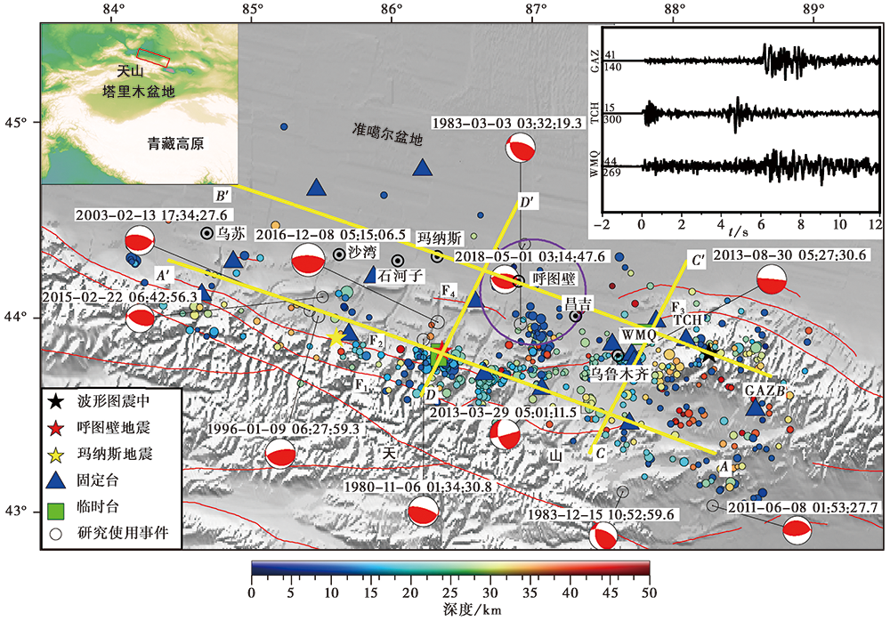
图 1 研究区主要断裂和所使用台站及地震震中分布图 图中红色实线为断层: F1亚马特断裂; F2准噶尔南缘断裂; F3博格达弧形断裂带; F4霍尔果斯-玛纳斯-吐谷鲁断裂。紫色圆圈为与储气库的距离≤30km的范围, 震源机制解为研究区1976—2018年MS>5.0地震, 数据来自GCMT。右上小图为2016年1月28日阜康 MS3.7 地震在50km震中距范围内台站所记录的地震波形, 震源深度为30km
Fig. 1 Distribution of major faults, stations and earthquake epicenters in the study area.
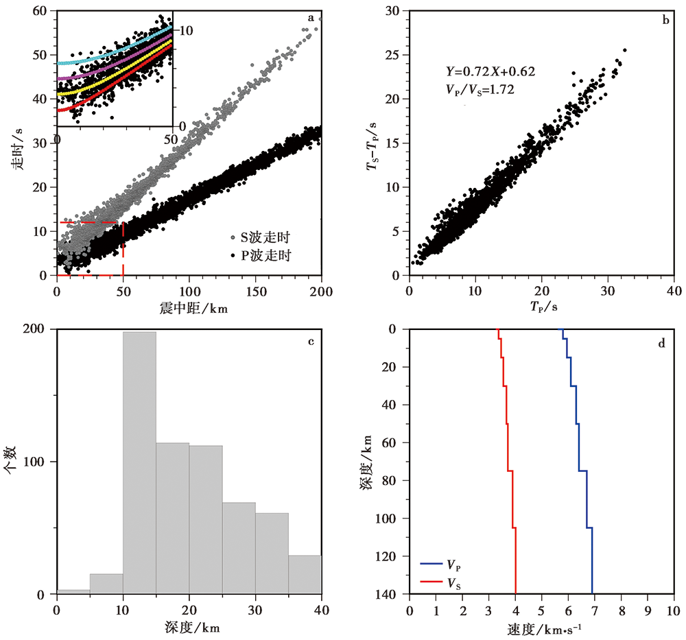
图 2 走时数据分布及初始速度模型 a 研究中选用的地震震相数据及不同震源深度的理论走时曲线, 其中红线、 黄线、 紫线和蓝线分别代表震源深度在10km、 20km、 30km和40km情况下的理论走时曲线; b 评估波速比平均变化的和达直线图; c 研究中使用的地震震源深度分布直方图; d本研究使用的初始速度模型
Fig. 2 Travel time data distribution and initial velocity model.
| 地壳分层 | P波速度/km·s-1 | S波速度/km·s-1 | 深度/km |
|---|---|---|---|
| 第1层 | 5.960 | 3.573 | 22 |
| 第2层 | 6.301 | 3.582 | 57 |
| 莫霍面 | 8.364 | 4.830 |
表1 “3400走时表”速度模型
Table1 Crustal velocity model of the“3400 travel time table”
| 地壳分层 | P波速度/km·s-1 | S波速度/km·s-1 | 深度/km |
|---|---|---|---|
| 第1层 | 5.960 | 3.573 | 22 |
| 第2层 | 6.301 | 3.582 | 57 |
| 莫霍面 | 8.364 | 4.830 |

图 3 确定反演中VP及VP/VS阻尼因子的折衷曲线 a 确定VP反演的阻尼因子; b 确定VP/VS反演的阻尼因子
Fig. 3 Determination of the trade-off curves of VP and VP/VS damping factors in inversion.
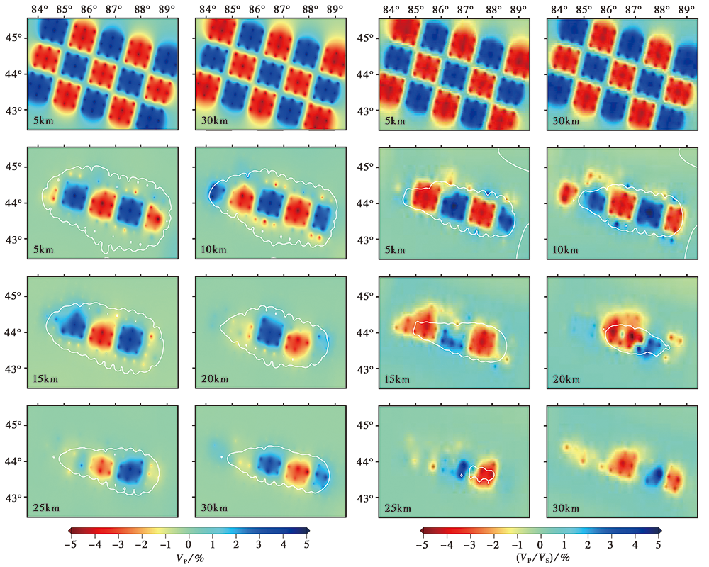
图 4 P波及VP/VS速度模型 “棋盘式”分辨率测试及结果
Fig. 4 Results of checkerboard test for VP and VP/VS ratio.
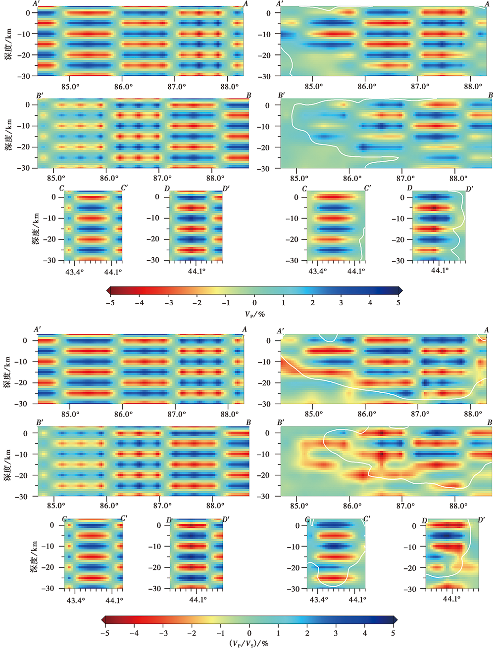
图 5 4条剖面VP及VP/VS速度模型 “棋盘式”分辨率测试及结果 AA'、 BB'、 CC'和DD'的具体位置见图1
Fig. 5 Result of checkerboard test for VP and VP/VS ratio at 4 sections.
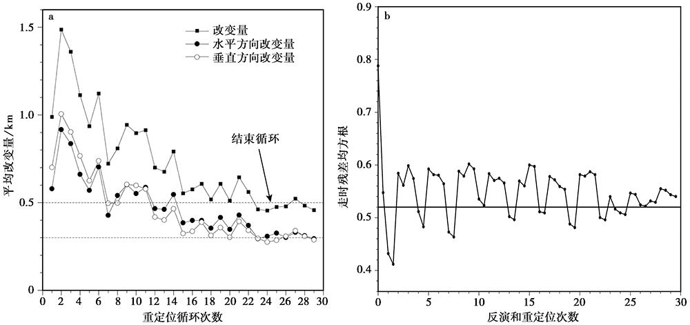
图 6 迭代前、 后震源位置的改变量及走时残差值的均方根
Fig. 6 The root-mean-square of the source position change and travel time residual value before and after iteration.
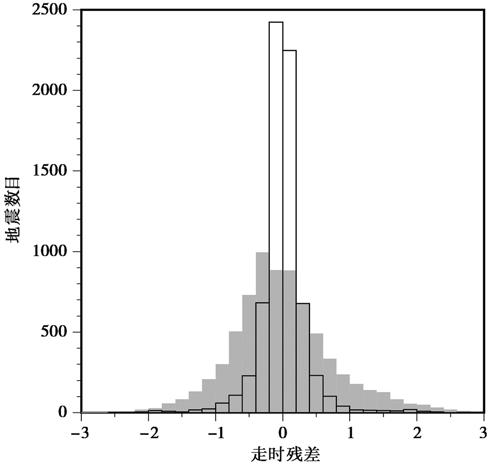
图 7 层析成像反演前、 后走时残差分布直方图 灰色矩形为反演前走时残差分布直方图; 透明矩形为反演后走时残差分布直方图
Fig. 7 Histogram of travel time residual distribution before and after tomography inversion.
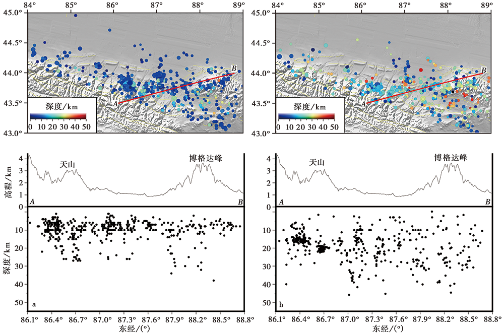
图 8 地震目录与重定位后的震中位置分布图 a 重定位前震中位置分布图; b 重定位后震中位置分布图
Fig. 8 Earthquake catalog, and distribution of epicenters after relocation.
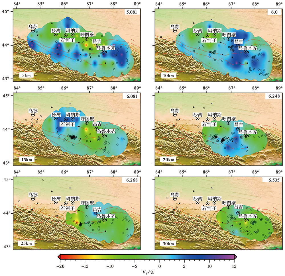
图 9 5km、 10km、 15km、 20km、 25km和30km深度处P波相对于每层平均速度的扰动量
Fig. 9 Map of P wave perturbation relative to the average velocity at depth of 5km, 10km, 15km, 20km, 25km and 30km.
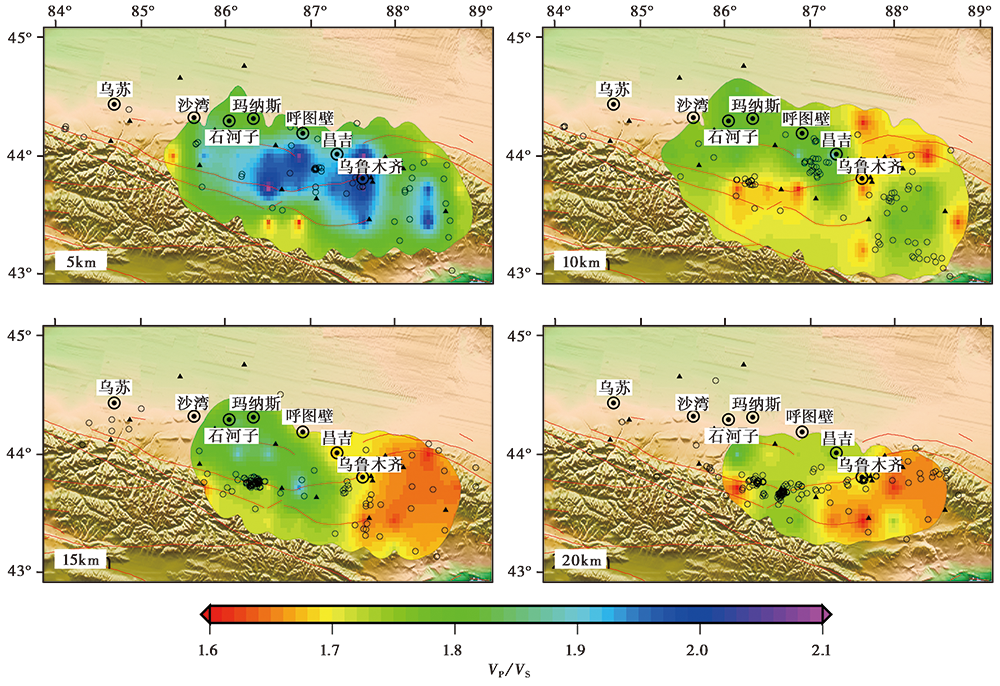
图 10 5km、 10km、 15km和20km波速比(VP/VS)水平切片
Fig. 10 Map of VP/VS ratios at depth of 5km, 10km, 15km and 20km.
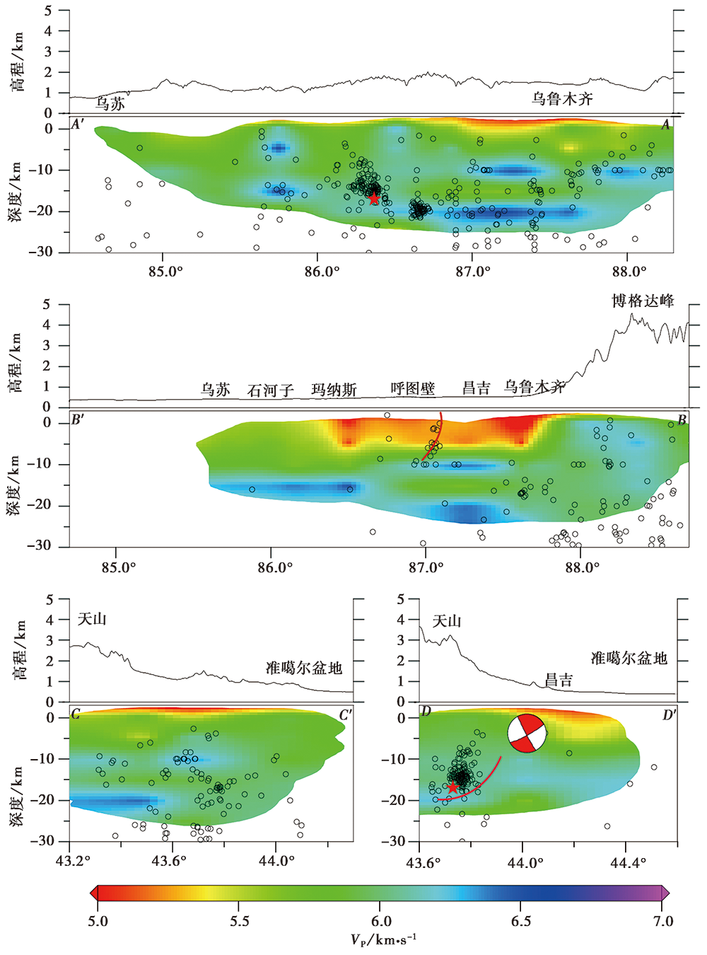
图 11 沿图1中4条深度剖面的P波速度结构图像
Fig. 11 P wave velocity structure beneath the 4 sections shown in Fig. 1.
| [1] | 蔡妍, 吴建平, 明跃红, 等. 2019. 新疆天山地区壳幔S波速度结构特征及变形分析[J]. 地球物理学报, 62(11): 4214-4226. |
| CAI Yan, WU Jian-ping, MING Yue-hong, et al. 2019. Crust-mantle S wave velocity structures beneath Tianshan area and its deformation analysis[J]. Chinese Journal of Geophysics, 62(11): 4214-4226. (in Chinese) | |
| [2] | 陈向军, 上官文明, 宋秀青, 等. 2014. 新疆全区和分区地壳速报模型的分析[J]. 中国地震, 30(2): 178-187. |
| CHEN Xiang-jun, SHANGGUAN Wen-ming, SONG Xiu-qing, et al. 2014. Study on crustal velocity model in Xinjiang and its subareas[J]. Earthquake Research in China, 30(2): 178-187. (in Chinese) | |
| [3] | 邓起东, 冯先岳, 张培震, 等. 1999. 乌鲁木齐山前坳陷逆断裂褶皱带及其形成机制[J]. 地学前缘, 6(4): 191-201. |
| DENG Qi-dong, FENG Xian-yue, ZHANG Pei-zhen, et al. 1999. Reverse fault and fold zone in the Urumqi range-front depression of the northern Tianshan and its genetic mechanism[J]. Earth Science Frontiers, 6(4): 191-201. (in Chinese) | |
| [4] | 冯先岳. 1997. 新疆古地震[M]. 乌鲁木齐: 新疆科技卫生出版社. |
| FENG Xian-yue. 1997. Ancient Earthquakes of Xinjiang[M]. Xinjiang Sci-Tech and Public Health Press, Urumqi. (in Chinese) | |
| [5] | 郭飚, 刘启元, 陈九辉, 等. 2006. 中国境内天山地壳上地幔结构的地震层析成像[J]. 地球物理学报, 49(6): 1693-1700. |
|
GUO Biao, LIU Qi-yuan, CHEN Jiu-hui, et al. 2006. Seismic tomography of the crust and upper mantle structure underneath the Chinese Tianshan[J]. Chinese Journal of Geophysics, 49(6): 1693-1700. (in Chinese)
DOI URL |
|
| [6] |
刘建明, 王琼, 李金, 等. 2018. 2016年12月8日呼图壁 MS6.2 地震序列重定位与发震构造[J]. 地震地质, 40(3): 566-578. doi: 10.3969/j.issn.0253-4967.2018.03.005.
DOI |
| LIU Jian-ming, WANG Qiong, LI Jin, et al. 2018. Relocation of the Hutubi MS6.2 earthquake sequence on 8 December 2016 and analysis of the seismogenic structure[J]. Seismology and Geology, 40(3): 566-578. (in Chinese) | |
| [7] | 罗福忠, 阮成雯, 方伟. 2006. 新疆博格达山北缘现今构造运动特征[J]. 内陆地震, 20(2): 109-114. |
| LUO Fu-zhong, RUAN Chen-wen, FANG Wei. 2006. Modern tectonic motion character on the northern verge of Bogurda Mountain, in Xinjiang[J]. Inland Earthquake, 20(2): 109-114. (in Chinese) | |
| [8] | 邵学钟, 张家茹, 范会吉, 等. 1996. 天山造山带地壳结构与构造: 乌鲁木齐-库尔勒地震转换波测深剖面[J]. 地球物理学报, 39(3): 336-346. |
| SHAO Xue-zhong, ZHANG Jia-ru, FAN Hui-ji, et al. 1996. The crust structures of Tianshan orogenic belt: A deep sounding work by converted waves of earthquakes along Urumqi-Korla profile[J]. Chinese Journal of Geophysics, 39(3): 336-346. (in Chinese) | |
| [9] | 吴建平, 黄媛, 张天忠, 等. 2009. 汶川 MS8.0 地震余震分布及周边区域P波三维速度结构研究[J]. 地球物理学报, 52(2): 320-328. |
| WU Jian-ping, HUANG Yuan, ZHANG Tian-zhong, et al. 2009. Aftershock distribution of the MS8.0 Wenchuan earthquake and three-dimensional P-wave velocity structure in and around source region[J]. Chinese Journal of Geophysics, 52(2): 320-328. (in Chinese) | |
| [10] | 胥颐, 刘福田, 刘建华, 等. 2000a. 天山地震带的地壳结构与强震构造环境[J]. 地球物理学报, 43(2): 184-193. |
| XU Yi, LIU Fu-tian, LIU Jian-hua, et al. 2000a. Crustal structure and tectonic environment of strong earthquakes in the Tianshan earthquake belt[J]. Chinese Journal of Geophysics, 43(2): 184-193. (in Chinese) | |
| [11] | 胥颐, 刘福田, 刘建华, 等. 2000b. 中国大陆西北造山带及其毗邻盆地的地震层析成像[J]. 中国科学(D辑), 30(2): 113-122. |
| XU Yi, LIU Fu-tian, LIU Jian-hua, et al. 2000b. Seismic tomography beneath the orogenic belts and adjacent basins of northwestern China[J]. Science in China(Ser D), 30(2): 113-122. (in Chinese) | |
| [12] |
杨文, 程佳, 姚琪, 等. 2018. 2016年新疆呼图壁6.2级地震发震构造[J]. 地震地质, 40(5): 1100-1113. doi: 10.3969/j.issn.0253-4967.2018.05.010.
DOI |
| YANG Wen, CHENG Jia, YAO Qi, et al. 2018. The preliminary study on the sesimogenic structure of the Hutubi MS6.2 earthquake[J]. Seismology and Geology, 40(5): 1100-1113. (in Chinese) | |
| [13] | 杨晓平, 顾梦林, 孙振国, 等. 2002. 1906年新疆玛纳斯大震区的多层次逆冲构造与深部结构[J]. 地震地质, 24(3): 303-314. |
| YANG Xiao-ping, GU Meng-lin, SUN Zhen-guo, et al. 2002. Multilayered reverse faults and deep structures in the Manas earthquake area, northern Tianshan[J]. Seismology and Geology, 24(3): 303-314. (in Chinese) | |
| [14] | Avouac J P, Tapponnier P, Bai M, et al. 1993. Active thrusting and folding along the northern Tien Shan and Late Cenozoic rotation of the Tarim relative to Dzungaria and Kazakhstan[J]. Journal of Geophysical Research: Solid Earth, 98(B4): 6755-6804. |
| [15] |
Chatterjee S, Goswami A, Scotese C R. 2013. The longest voyage: Tectonic, magmatic, and paleoclimatic evolution of the Indian plate during its northward flight from Gondwana to Asia[J]. Gondwana Research, 23(1): 238-267.
DOI URL |
| [16] | Dawson P B, Chouet B, Lahr J C, et al. 1992. Spatial relationship between LP earthquake and a shallow three-dimensional velocity anomaly beneath Redoubt Volcano, Alaska[R]. Eos Transactions American Geophysical Union, 73: 343. |
| [17] |
Douilly R, Ellsworth W L, Kissling E. 2016. 3-D velocity structure in southern Haiti from local earthquake tomography[J]. Journal of Geophysical Research: Solid Earth, 121(12): 8813-8832.
DOI URL |
| [18] |
Eberhart-Phillips D. 1990. Three-dimensional P and S velocity structure in the Coalinga region, California[J]. Journal of Geophysical Research, 95(B10): 15343-15363.
DOI URL |
| [19] |
He C S, Santosh M, Chen X H. 2014. Crustal growth and tectonic evolution of the Tianshan orogenic belt, NW China: A receiver function analysis[J]. Journal of Geodynamics, 75:41-52.
DOI URL |
| [20] |
He C S, Santosh M. 2018. Role of mantle dynamics in rebuilding the Tianshan orogenic belt in NW China: A seismic tomographic investigation[J]. Journal of Geodynamics, 116:37-46.
DOI URL |
| [21] |
Langin W R, Brown L D, Sandvol E A. 2003. Seismicity of central Tibet from project INDEPTH Ⅲ seismic recordings[J]. Bulletin of the Seismological Society of America, 93(5): 2146-2159.
DOI URL |
| [22] | Lei J S, Zhao D P. 2007. Teleseismic P-wave tomography and the upper mantle structure of the central Tien Shan orogenic belt[J]. Physics of the Earth and PlanetaryInteriors, 162(3-4): 165-185. |
| [23] |
Lei X Q, Chen Y P, Zhao C B. 2013. Three-dimensional thermo-mechanical modeling of the Cenozoic uplift of the Tianshan Mountains driven tectonically by the Pamir and Tarim[J]. Journal of Asian Earth Sciences, 62:797-811.
DOI URL |
| [24] |
Li Y Q, Wei D T, Tian H. 2018. 3D structural model of an out-of-sequence earthquake in China: Implication for the reactivation of positive inversion structures along the northern Tianshan fold-and-thrust belt[J]. Tectonics, 37(12): 4359-4376.
DOI URL |
| [25] |
Lin G, Shearer P M, Matoza R S. 2014. Three-dimensional seismic velocity structure of Mauna Loa and Kilauea volcanoes in Hawaii from local seismic tomography[J]. Journal of Geophysical Research: Solid Earth, 119(5): 4377-4392.
DOI URL |
| [26] |
Lin G, Thurber C H. 2012. Seismic velocity variations along the rupture zone of the 1989 Loma Prieta earthquake, California[J]. Journal of Geophysical Research: Solid Earth, 117: B09301. doi: 10.1029/2011JB009122.
DOI |
| [27] | Lin G, Thurber C H, Zhang H, et al. 2010. A California statewide three-dimensional seismic velocity model from both absolute and differential times[J]. Bulletin of the Seismological Society of America, 10:225-240. |
| [28] |
Lu R Q, He D F, Xu X W. 2018. Seismotectonics of the 2016 M 6.2 Hutubi earthquake: Implications for the 1906 M7.7 Manas earthquake in the northern Tian Shan belt, China [J]. Seismological Research Letters, 89(1): 13-21.
DOI URL |
| [29] |
Molnar P, Tapponnier P. 1975. Cenozoic tectonics of Asia: Effects of a continental collision: Features of recent continental tectonics in Asia can be interpreted as results of the India-Eurasia collision[J]. Science, 189(4201): 419-426.
PMID |
| [30] |
Pirajno F. 2010. Intracontinental strike-slip faults, associated magmatism, mineral systems and mantle dynamics: Examples from NW China and Altay-Sayan(Siberia)[J]. Journal of Geodynamics, 50(3): 325-346.
DOI URL |
| [31] | Shearer P M. 2009. Introduction to Seismology[M]. Cambridge University Press, Cambridge, UK: 117-127. |
| [32] |
Tang L L, Lu Z, Zhang M, et al. 2018. Seismicity induced by simultaneous abrupt changes of injection rate and well pressure in Hutubigas field[J]. Journal of Geophysical Research: Solid Earth, 123(7): 5929-5944.
DOI URL |
| [33] |
Tapponnier P, Xu Z Q, Roger F. 2001. Oblique stepwise rise and growth of the Tibet Plateau[J]. Science, 294(5547): 1671-1677.
PMID |
| [34] |
Thurber C H. 1983. Earthquake locations and three-dimensional crustal structure in the Coyote Lake area, central California[J]. Journal of Geophysical Research, 88(B10): 8226-8236.
DOI URL |
| [35] | Thurber C H. 1993. Local earthquake tomography: Velocities and VP/VS-theory [G]// Iyer H M, Hiahara K(eds).Seismic Tomography: Theory and Practice. Chapman and Hall, London: 563-583. |
| [36] |
Thurber C, Eberhart-Phillips D. 1999. Local earthquake tomography with flexible griding[J]. Computers & Geosciences, 25(7): 809-818.
DOI URL |
| [37] |
Wu Z M, Francis T. 1987. Nature of the upper crust beneath central Tibet[J]. Earth and Planetary Science Letters, 84(2): 204-210.
DOI URL |
| [38] |
Xin H L, Zhang H J, Kang M. 2019. High-resolution lithospheric velocity structure of continental China by double-difference seismic travel-time tomography[J]. Seismological Research Letters, 90(1): 229-241.
DOI URL |
| [39] |
Zhang D Y, Zhang Z C, Encarnación J, et al. 2012. Petrogenesis of the Kekesai composite intrusion, western Tianshan, NW China: Implications for tectonic evolution during late Paleozoic time[J]. Lithos, 146-147:65-79.
DOI URL |
| [40] |
Zhang X, Brown D, Deng Y F. 2011. Crustal composition model across the Bangong-Nujiang suture belt derived from INDEPTH Ⅲ velocity data[J]. Journal of Geophysics and Engineering, 8(4): 549-559.
DOI URL |
| [41] | Zhang Z J, Klemperer S L. 2005. West-east variation in crustal thickness in northern Lhasa block, central Tibet, from deep seismic sounding data[J]. Journal of Geophysical Research: Solid Earth, 110(B9): B09403. |
| [42] |
Zhao J M, Liu G D, Lu Z X. 2003. Lithospheric structure and dynamic processes of the Tianshan orogenic belt and the Junggar Basin[J]. Tectonophysics, 376(3-4): 199-239.
DOI URL |
| [1] | 李细兵, 陶小三, 顾勤平, 彭小波, 王宇, 朱峰. 郯庐断裂带中南段地壳上地幔顶部P波速度结构及其构造意义[J]. 地震地质, 2026, 48(2): 423-441. |
| [2] | 戴宗辉, 曲均浩, 徐宁, 李翠芹, 李冬梅, 尹玉振. 2023年微山震群震源区三维速度结构与发震构造[J]. 地震地质, 2025, 47(6): 1649-1666. |
| [3] | 李婷婷, 缪发军, 孙业君, 范文华, 宫杰, 顾勤平, 杜航, 孙小航, 张岑, 李子烨. 江苏江都震群震源区速度结构及构造特征[J]. 地震地质, 2025, 47(5): 1343-1363. |
| [4] | 张天继, 秦敏, 党文杰, 金明培, 李凤英, 杨黎薇. 接收函数与瑞利波相速度联合反演腾冲-保山地区的S波速度结构[J]. 地震地质, 2025, 47(5): 1364-1381. |
| [5] | 李若豪, 雷建设, 宋晓燕. 大同火山群及邻区三维地壳S波速度结构: 来自背景噪声面波直接成像约束[J]. 地震地质, 2025, 47(4): 1090-1112. |
| [6] | 杨建文, 金明培, 叶泵, 茶文剑, 黑贺堂. 基于背景噪声成像方法研究滇西北中上地壳三维速度结构及孕震环境[J]. 地震地质, 2025, 47(4): 1113-1131. |
| [7] | 宫猛, 邹献昆, 王晓山, 李广, 盛书中, 李红星, 徐荣华, 路昌胜. 京西北地区地壳速度结构与地震重新定位联合反演[J]. 地震地质, 2025, 47(4): 1132-1151. |
| [8] | 吉宇, 张广伟, 任俊杰, 何静, 王肖薇. 基于背景噪声成像研究北京地区三维S波速度结构[J]. 地震地质, 2025, 47(1): 306-324. |
| [9] | 冯策, 宋秀青, 王仁涛, 刘昊岚. 基于背景噪声层析成像反演上海及邻区S波速度结构[J]. 地震地质, 2024, 46(6): 1374-1390. |
| [10] | 侯颉, 吴庆举, 余大新, 叶庆东. 阿尔山火山群面波层析成像[J]. 地震地质, 2024, 46(4): 893-915. |
| [11] | 于悦颖, 李正楷, 杨云, 康清清, 钱佳威, 王俊菲, 瞿旻, 周昱辰, 李迎春, 许田. 2022年东台地震序列区域速度结构和精确定位[J]. 地震地质, 2024, 46(3): 627-644. |
| [12] | 曹颖, 钱佳威, 黄江培, 周青云. 云南洱源地区地壳三维精细速度结构成像[J]. 地震地质, 2024, 46(1): 162-183. |
| [13] | 李强, 吴建平. 福建地区地壳三维P波速度结构与构造含义[J]. 地震地质, 2023, 45(4): 970-986. |
| [14] | 宫猛, 吕坚, 郑勇, 谢祖军, 盛书中, 张杏棉. 华南地块及邻区基于背景噪声的壳幔三维S波速度结构[J]. 地震地质, 2022, 44(4): 1011-1028. |
| [15] | 王亮, 焦明若, 钱蕊, 张博, 杨士超, 邵媛媛. 利用双差地震成像方法反演辽南地区地壳速度结构[J]. 地震地质, 2022, 44(2): 378-394. |
| 阅读次数 | ||||||
|
全文 |
|
|||||
|
摘要 |
|
|||||
