地震地质 ›› 2025, Vol. 47 ›› Issue (2): 561-576.DOI: 10.3969/j.issn.0253-4967.2025.02.20240066
陈建波1)( ), 郑黎明1), 李涛2), 陈杰2), 姚远1), 钱黎2), 张博譞2), 胡宗凯2), 刘冠伸2), 李金1)
收稿日期:2024-05-13
修回日期:2024-06-12
出版日期:2025-04-20
发布日期:2025-06-07
作者简介:陈建波, 男, 1976年生, 高级工程师, 主要从事地震地质与活动构造方面的研究, E-mail: 123827172@qq.com。
基金资助:
CHEN Jian-bo1)(), ZHENG Li-ming1), LI Tao2), CHEN Jie2), YAO Yuan1), QIAN Li2), ZHANG Bo-xuan2), HU Zong-kai2), LIU Guan-shen2), LI Jin1)
Received:2024-05-13
Revised:2024-06-12
Online:2025-04-20
Published:2025-06-07
摘要:
2024年1月23日新疆乌什发生 MS7.1 地震, 震中位于西南天山乌什凹陷, 极震区烈度为Ⅸ度。此次地震是新疆地区近十年以来最大的地震, 也是自1992年吉尔吉斯斯坦Suusamyr MS7.3地震以来天山地震带内最大的地震。地震造成的人员伤亡、 房屋破坏相对较轻, 但次生地质灾害较为严重。文中通过震后第一时间野外科学考察、 大比例尺卫星影像解译及无人机航拍, 对宏观震中及震区地质灾害的空间位置、 基本类型和发育特征等进行了调查。结果表明, 乌什地震宏观震中主要位于微观震中以南约8km的别迭里河—恰勒玛提河之间, 地质灾害主要沿构造走向集中分布在微观震中东、 西两侧30km范围内的山区, 灾害类型多以岩崩、 滑坡、 滚石、 边坡失稳和地裂缝为主, 尤其以地震崩塌和地裂缝最为突出, 偶有沿地裂缝的喷砂冒水现象, 地震崩塌主要集中在玉山古溪河—科克留木苏河之间, 震中所在的别迭里河表现最为明显, 地裂缝主要集中在由新近系地层组成的别迭里背斜核部, 以张裂缝和张剪裂缝为主, 覆盖范围南北长2.53km, 东西宽0.2~1.2km, 面积约为2.2km2。本次调查的次生地质灾害的分布区与InSAR同震形变场给出的最大形变区在空间上具有较好的一致性, 表明构造变形对地质灾害形成具有显著的控制作用。
陈建波, 郑黎明, 李涛, 陈杰, 姚远, 钱黎, 张博譞, 胡宗凯, 刘冠伸, 李金. 2024年1月23日新疆乌什MS7.1地震宏观震中与地质灾害调查[J]. 地震地质, 2025, 47(2): 561-576.
CHEN Jian-bo, ZHENG Li-ming, LI Tao, CHEN Jie, YAO Yuan, QIAN Li, ZHANG Bo-xuan, HU Zong-kai, LIU Guan-shen, LI Jin. GEOLOGICAL HAZARD CHARACTERISTICS AND MACRO-SCOPIC EPICENTER OF WUSHI MS7.1 EARTHQUAKE ON JANUARY 23, 2024, XINJIANG[J]. SEISMOLOGY AND GEOLOGY, 2025, 47(2): 561-576.
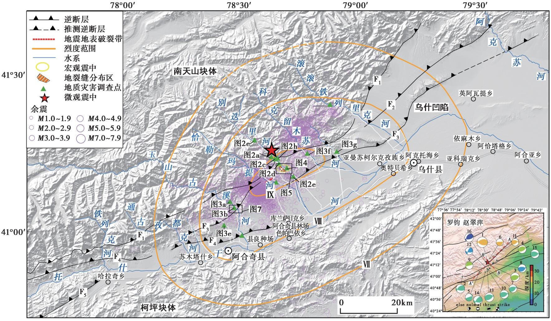
图 1 2024年1月23日新疆乌什 MS7.1 地震烈度与主、 余震中位置及地质灾害调查点 图中断层主要依据1︰20万地质图, 时间截至2024年2月7日, 主、 余震的震源机制解主要来自中地震局预测所 ①
Fig. 1 Seismic intensity map and location of geological hazard survey sites and main and aftershock of Wushi MS7.1 in Xinjiang on January 23, 2024.
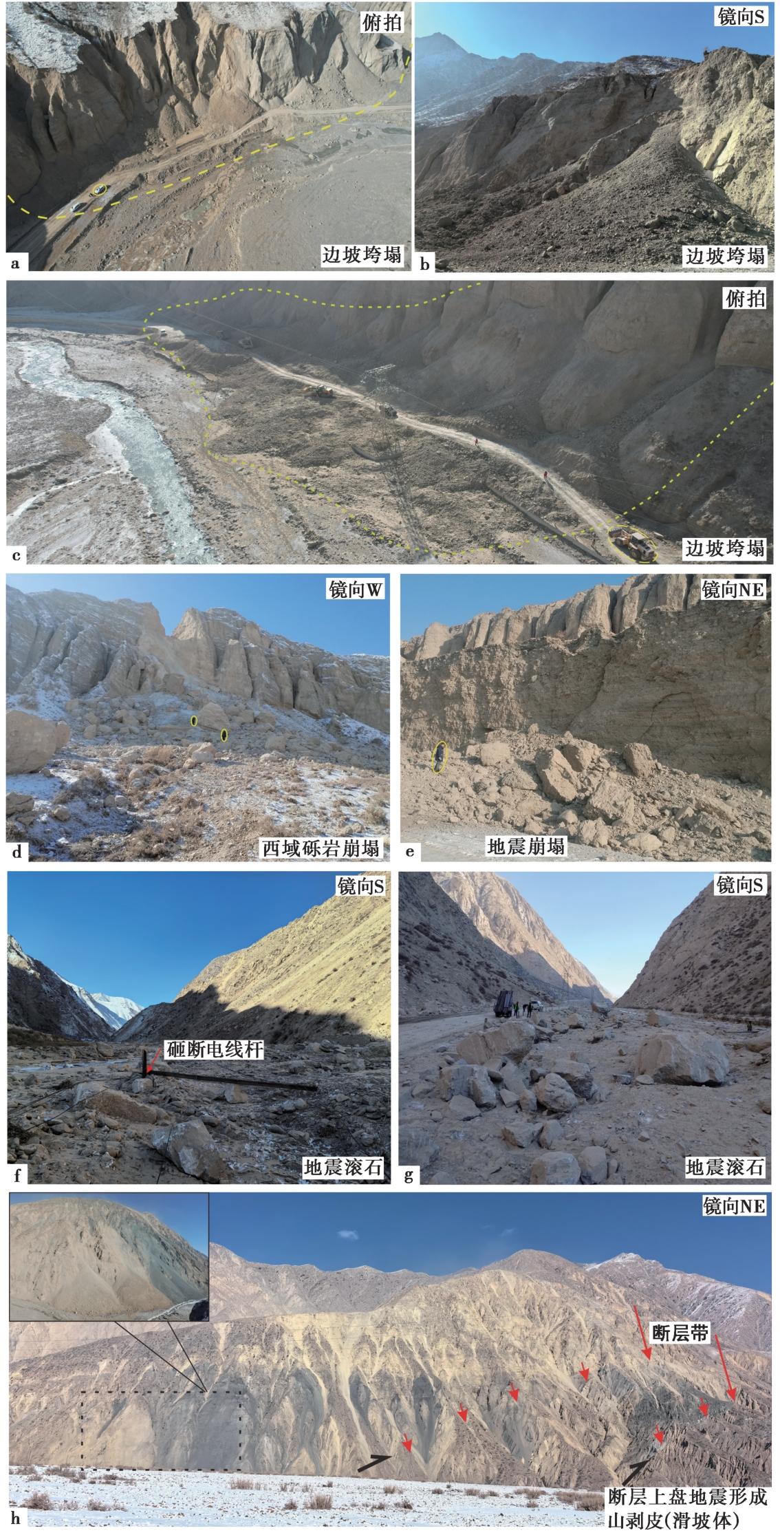
图 2 别迭里河谷的地震地质灾害 a、 b 河流阶地崩塌形成了倒石堆群1, 阻塞道路; c 河流阶地崩塌形成了倒石堆群2, 阻塞道路; d 河谷西岸西域砾岩崩塌形成的岩崩和滚石; e 河谷东岸松散堆积垮塌; f 古生界灰岩崩塌产生的滚石砸断电线杆; g 古生界灰岩崩塌形成的巨大滚石砸倒隔离墩和路桩, 阻塞道路; h 别迭里沟古生界和西域砾岩分界处断层附近地震形成的形成山剥皮现象(滑坡群)
Fig. 2 Earthquake-induced geological hazards in Biedieli valley.
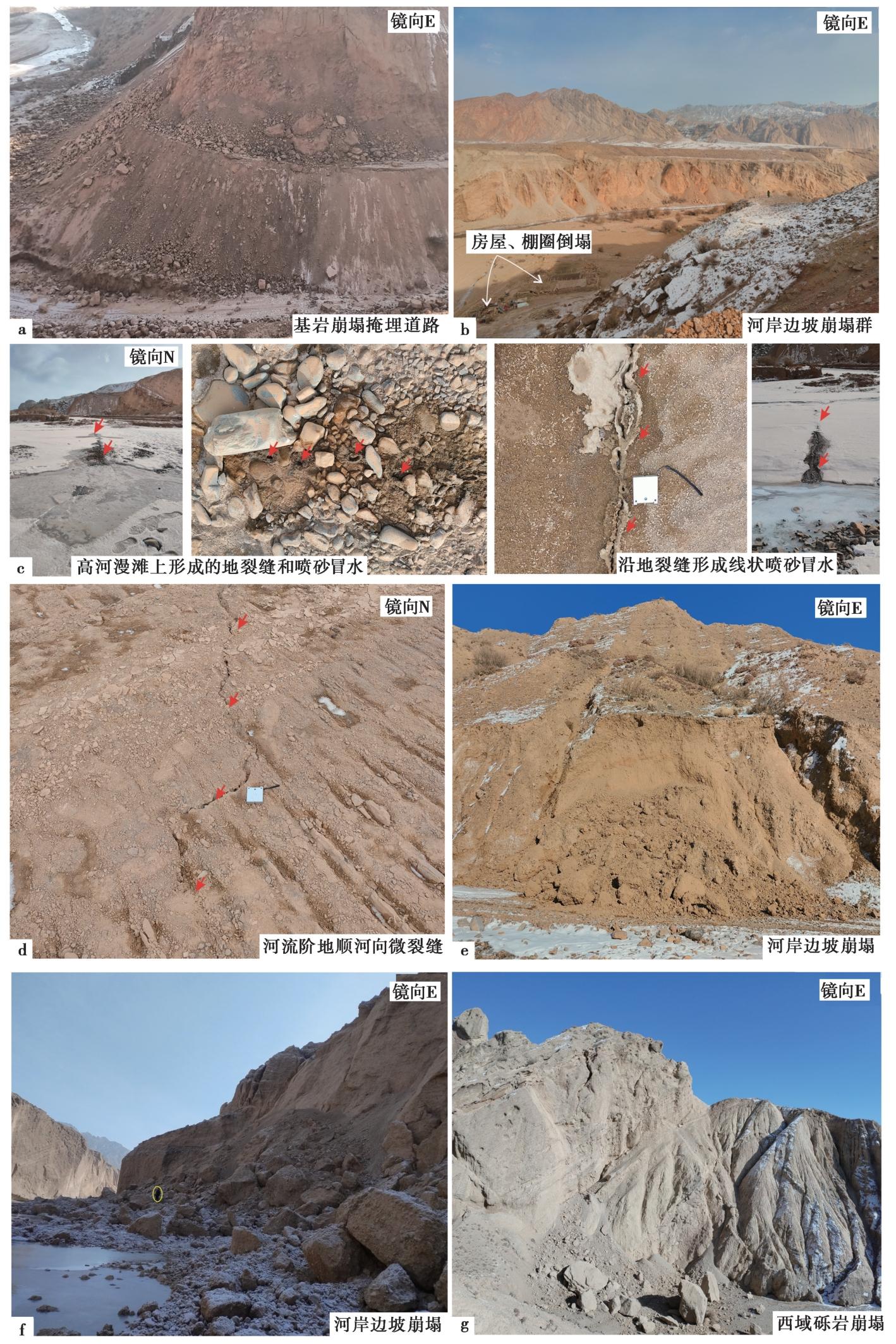
图 3 玉山古溪沟与科克留木苏沟的地震地质灾害 a 玉山古溪沟公路边坡新近系泥岩崩塌, 阻塞道路; b 玉山古溪沟的河岸崩塌形成的倒石堆群和倒塌的房屋; c 玉山古溪沟内沿地裂缝伴生的轻微砂土液化; d 玉山古溪沟河流低阶地上发育的轻微地裂缝; e 玉山古溪沟河流西侧冲沟内形成的小规模的地震崩塌体; f 低阶地上发育的轻微地裂缝科克留木苏河东岸河岸阶地松散堆积物崩塌; g 巴里度尔沟西域砾岩崩塌
Fig. 3 Earthquake-induced geological disasters in Yushanguxi gully and Kekliusu gully.
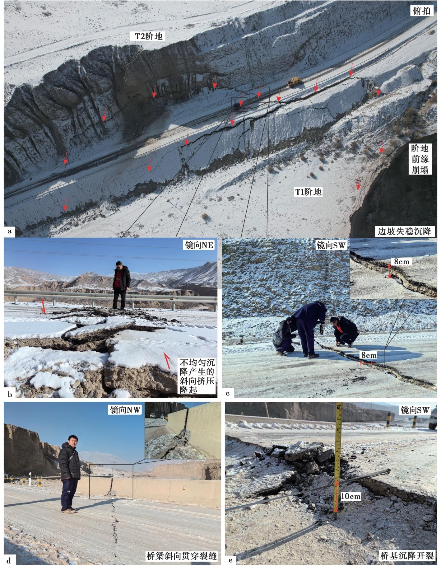
图 4 别迭里河谷地震造成河岸边坡失稳产生的路基沉降和桥梁破裂
Fig. 4 Roadbed settlement and bridge rupture caused by the instability of riverbank slopes in the Biedieli river valley caused by the earthquake.
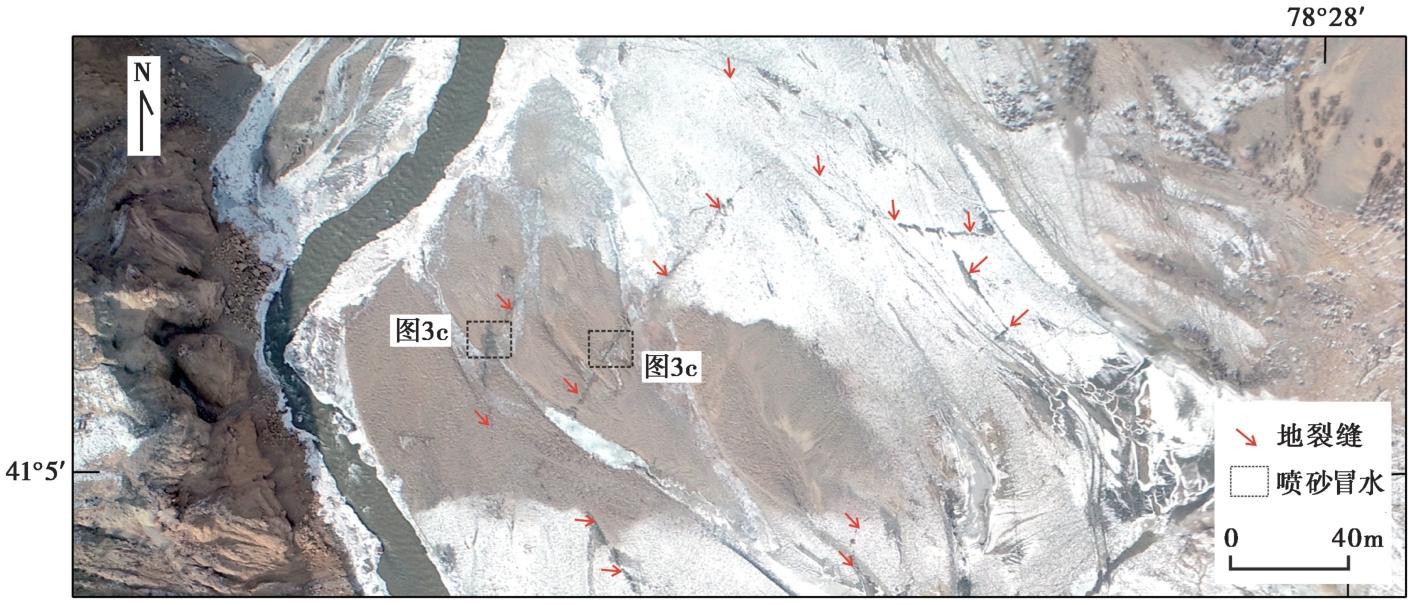
图 5 玉山古溪河高河漫滩和低阶地上形成的地裂缝及喷砂冒水点平面展布图
Fig. 5 Plane layout of ground fractures and sandblasting water points on the low terrace of Yushanguxi valley.
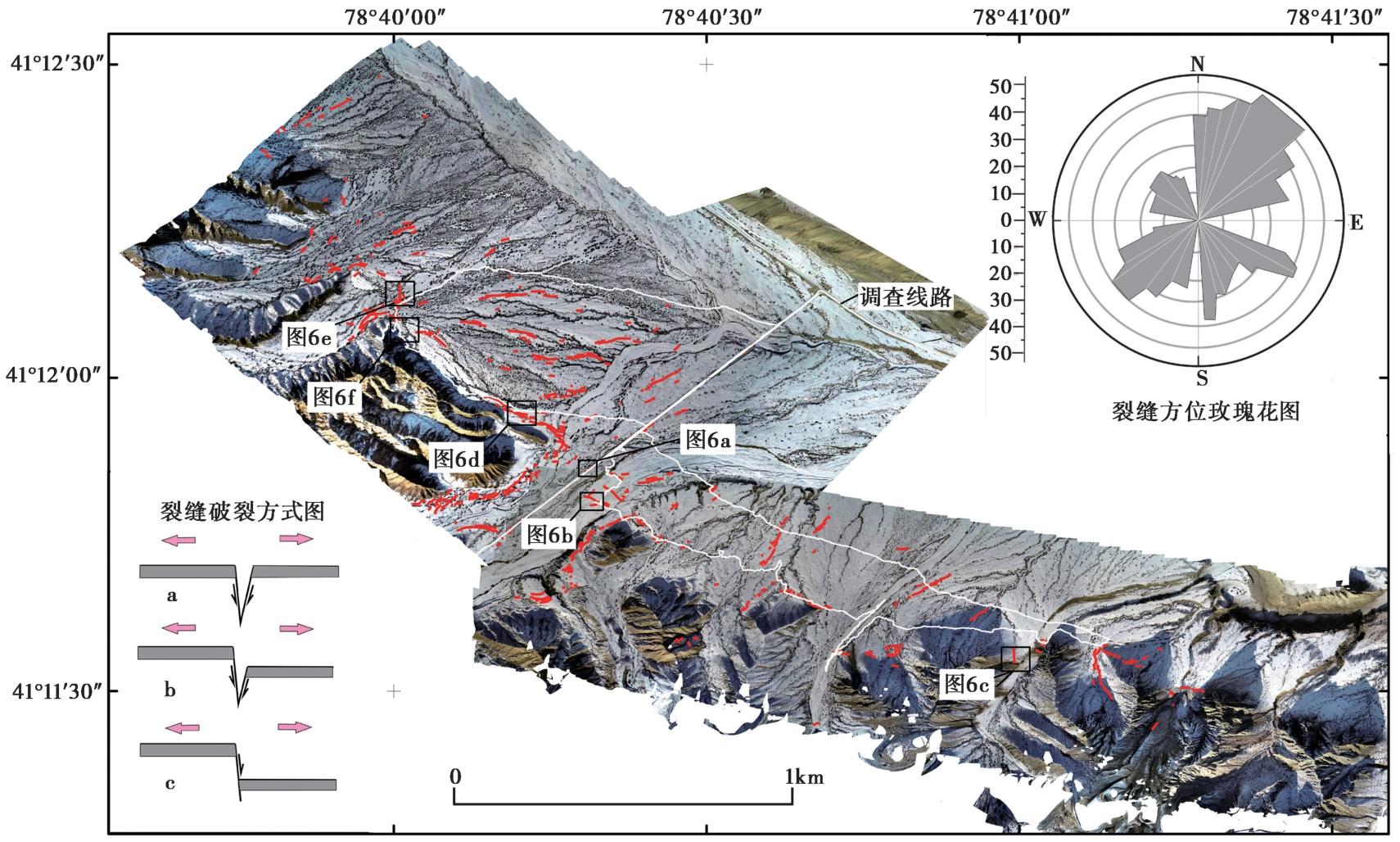
图 6 别迭里河谷西岸新近系背斜核部地震形成的密集裂缝平面展布图
Fig. 6 Plane distribution of dense fractures formed by earthquakes at the core of the Neogene anticline on the west bank of Biedieli river valley.

图 7 别迭里河谷西岸新近系背斜核部的地震裂缝和基岩断层及地震岩崩 a NW向裂隙, 为重力作用产生的拉张性裂缝, 断错现代河床; b NW向裂缝, 其分布范围和走向大致与局部地形等高线平行, 沿地貌高差呈台阶状或斜裂展布; c 在柏油路面产生的NW向斜向挤压鼓包; d 背斜南翼西域组砾岩内部的基岩断层活动产生岩崩; e、 f 近SN向构造裂缝, 沿已有基岩断层切割新近系泥岩, 并形成垂向位错
Fig. 7 Earthquake fractures, bedrock faults and seismic rock collapses at the core of the Neogene anticline on the west bank of Biedieli river valley.
| [1] |
付碧宏, 贾营营. 2010. 南天山乌什前陆逆冲褶皱构造带的晚新生代构造地貌特征与地震活动[J]. 地质科学, 45(4): 917-929.
|
|
|
|
| [2] |
何骁慧, 李涛, 吴传勇, 等. 2020. 基于区域地震波形的2017年新疆精河 MS6.6 地震破裂方向性及发震构造研究[J]. 地球物理学报, 63(4): 1459-1471.
DOI |
|
|
|
| [3] |
黄润秋, 裴向军, 李天斌. 2008. 汶川地震触发大光包巨型滑坡基本特征及形成机理分析[J]. 工程地质学报, 16(6): 730-741.
|
|
|
|
| [4] |
黄伟亮, 杨晓平, 李安, 等. 2015. 焉耆盆地北缘和静逆断裂-褶皱带中晚第四纪变形速率[J]. 地震地质, 37(3): 675-696.
|
|
DOI |
|
| [5] |
李安, 冉勇康, 刘华国, 等. 2016. 西南天山柯坪推覆系西段全新世构造活动特征和古地震[J]. 地球科学进展, 31(4): 377-390.
DOI |
|
DOI |
|
| [6] |
李涛, 陈杰, 肖伟鹏. 2013. 帕米尔-天山对冲带明尧勒背斜西S倾伏端晚第四纪褶皱变形[J]. 地震地质, 35(2): 234-246. doi: 10.3969/j.issn.0253-4967.2013.02.004.
|
|
DOI |
|
| [7] |
李涛, 陈杰, 肖伟鹏. 2014. 滑脱褶皱陡坎的变形特征和运动学模型: 以帕米尔-南天山前陆地区明尧勒背斜为例[J]. 地震地质, 36(3): 677-691. doi: 10.3969/j.issn.0253-4967.2014.03.011.
|
|
|
|
| [8] |
刘建明, 王琼, 李金, 等. 2018. 2016年12月8日呼图壁 MS6.2 地震序列重定位与发震构造[J]. 地震地质, 40(3): 566-578. doi: 10.3969/j.issn.0253-4967.2018.03.005.
|
|
DOI |
|
| [9] |
卢华复, 贾东, 蔡东升, 等. 1998. 塔西北柯坪剪切挤压构造[J]. 高校地质学报, 4(1): 49-58.
|
|
|
|
| [10] |
曲国胜, 李亦纲, 陈杰, 等. 2003. 柯坪塔格推覆构造几何学、 运动学及其构造演化[J]. 地学前缘, 10(S1): 142-152.
|
|
|
|
| [11] |
宋方敏, 闵伟, 韩竹军, 等. 2006. 柯坪塔格推覆体的新生代变形与扩展[J]. 地震地质, 28(2): 224-233.
|
|
|
|
| [12] |
田勤俭, 丁国瑜, 郝平. 2006. 南天山及塔里木北缘构造带西段地震构造研究[J]. 地震地质, 28(2): 213-223.
|
|
|
|
| [13] |
吴传勇, 阿里木江, 戴训也, 等. 2014. 西南天山迈丹断裂东段晚第四纪活动的发现及构造意义[J]. 地震地质, 36(4): 976-990. doi: 10.3969/j.issn.0253-4967.2014.04.004.
|
|
|
|
| [14] |
吴传勇, 李金, 刘建明, 等. 2017. 新疆皮山 MS6.5 地震: 发生在西昆仑山前的一次褶皱地震[J]. 地震地质, 39(2): 342-355. doi: 10.3969/j.issn.0253-4967.2017.02.006.
|
|
DOI |
|
| [15] |
许冲, 戴福初, 陈剑, 等. 2009. 汶川 MS8. 0地震重灾区次生地质灾害遥感精细解译[J]. 遥感学报, 13(4): 754-762.
|
|
|
|
| [16] |
许冲, 戴福初, 徐锡伟. 2010. 汶川地震滑坡灾害研究综述[J]. 地质论评, 56(6): 860-874.
|
|
|
|
| [17] |
杨晓平, 邓起东, 张培震, 等. 2008. 天山山前主要推覆构造区的地壳缩短[J]. 地震地质, 30(1): 111-131.
|
|
|
|
| [18] |
杨晓平, 冉洪流. 2010. 活动推覆构造区潜在震源的边界和震级上限: 以1902年阿图什 8¼ 级地震构造区为例[J]. 震灾防御技术, 5(2): 145-156.
|
|
|
|
| [19] |
姚远, 陈杰, 李涛, 等. 2018. 2016年11月25日新疆阿克陶 MW6.6 地震宏观震中与地质灾害[J]. 地震地质, 40(2): 426-439. doi: 10.3969/j.issn.0253-4967.2018.02.010.
|
|
DOI |
|
| [20] |
姚远, 胡伟华, 吴国栋, 等. 2016. 2015年7月3日新疆皮山 MS6.5 地震烈度与地震地质灾害特点[J]. 地震工程学报, 38(4): 663-668.
|
|
|
|
| [21] |
姚远, 李涛, 刘奇, 等. 2021. 2020年1月19日新疆伽师 MW6.0 地震震中区地质灾害特点[J]. 地震地质, 43(2): 410-429. doi: 10.3969/j.issn.0253-4967.2021.02.010.
|
|
DOI |
|
| [22] |
殷跃平, 张永双, 马寅生, 等. 2010. 青海玉树 MS7.1 地震地质灾害主要特征[J]. 工程地质学报, 18(3): 289-296.
|
|
|
|
| [23] |
张博譞, 钱黎, 李涛, 等. 2024. 2024年1月23日新疆乌什 MS7.1 地震地质灾害和地表破裂[J]. 地震地质, 46(1): 220-234. doi: 10.3969/j.issn.0253-4967.2024.01.013.
|
|
|
|
| [24] |
张文婷, 季灵运, 朱良玉, 等. 2021. 南天山前陆盆地的一次典型逆冲破裂事件: 2020年新疆伽师6.4级地震[J]. 地震地质, 43(2): 394-409. doi: 10.3969/j.issn.0253-4967.2021.02.009.
|
|
DOI |
|
| [25] |
赵瑞斌, 沈军, 李军. 2001. 1902年新疆阿图什 8¼级地震形变特征与发震模式初探[J]. 地震地质, 23(4): 493-500.
|
|
|
|
| [26] |
郑民, 雷刚林, 黄少英, 等. 2007. 南天山西段南缘断裂构造特征及对乌什凹陷发育的控制[J]. 地质科学, 42(4): 639-655.
|
|
|
|
| [27] |
|
| [1] | 陈长云, 尹海权. 新疆地区现今地壳变形特征与强震危险性概率预测[J]. 地震地质, 2025, 47(2): 384-404. |
| [2] | 陈子龙, 刘刚, 李琦, 陈威, 赵昕宇, 林牧, 陶隆文, 乔学军, 聂兆生. 2024年乌什MW7.0地震InSAR同震形变与发震构造[J]. 地震地质, 2025, 47(2): 429-447. |
| [3] | 王一鹰, 孙茜茜, 朱猛, 王纪强, 时丕龙, 王华林. 苍山-尼山断裂的现今构造活动及其对民居建筑的影响[J]. 地震地质, 2024, 46(6): 1426-1443. |
| [4] | 马思远, 许冲, 陈晓利. 地震崩塌滑坡危险性应急评估模型效果对比--以2022年6月1日 MW5.8芦山地震为例[J]. 地震地质, 2023, 45(4): 896-913. |
| [5] | 姚远, 李涛, 刘奇, 邸宁. 2020年1月19日新疆伽师MW6.0地震震中区地质灾害特点[J]. 地震地质, 2021, 43(2): 410-429. |
| [6] | 姚远, 陈杰, 李涛, 付博, 王浩然, 李跃华, 陈建波. 2016年11月25日新疆阿克陶MW6.6地震宏观震中与地质灾害[J]. 地震地质, 2018, 40(2): 426-439. |
| [7] | 吴传勇, 阿里木江, 戴训也, 吴国栋, 陈建波. 西南天山迈丹断裂东段晚第四纪活动的发现及构造意义[J]. 地震地质, 2014, 36(4): 976-990. |
| [8] | 雷生学, 冉勇康, 王虎, 陈立春, 李西, 吴富峣, 韩非, 刘成龙. 关于芦山7.0级地震在龙门一带是否存在同震地表破裂的讨论[J]. 地震地质, 2014, 36(1): 266-274. |
| [9] | 武强, 陈珮珮, 董东林, 孙卫东, 魏迎春. 基于GIS与ANN耦合技术的地裂缝灾情非线性模拟预测系统——以山西榆次地裂缝灾害为例[J]. 地震地质, 2002, 24(2): 249-257. |
| [10] | 吴富春, 方炜, 宋立胜, 王锋, 朱兴国, 景北科, 董星宏, 左永青. 西安市地热水开采与地面沉降、地裂缝关系的分析[J]. 地震地质, 2002, 24(2): 234-240. |
| [11] | 车用太, 刘五洲, 王基华, 林元武. 张北-尚义地震典型地段的地表破坏[J]. 地震地质, 1998, 20(2): 179-182. |
| [12] | 李建华, 郝书俭, 胡玉台, 于之水, 褚宝贵. 1976年唐山地震发震断裂的活动性研究[J]. 地震地质, 1998, 20(1): 27-33. |
| [13] | 易学发, 苏刚, 王卫东, 唐俊昌. 西安地裂缝带的基本特征与形成机制[J]. 地震地质, 1997, 19(4): 289-295. |
| [14] | 徐锡伟, 钱瑞华, 高震寰, 王辉, 雷军, 刘玉刚, 陈健, 郝书俭, 于之水, 杜新贵. 大同铁路分局地裂缝带的三维构造特征及其成因分析[J]. 地震地质, 1994, 16(4): 355-364. |
| [15] | 俞维贤, 柴天俊, 侯学英. 澜沧7.6级地震形变带[J]. 地震地质, 1991, 13(4): 343-352. |
| 阅读次数 | ||||||
|
全文 |
|
|||||
|
摘要 |
|
|||||
