地震地质 ›› 2026, Vol. 48 ›› Issue (5): 1438-1456.DOI: 10.3969/j.issn.0253-4967.20260029
赵申1),3)( ), 江国明1),2),*(), 李信富1), 赵大鹏4)
收稿日期:2026-03-13
修回日期:2026-05-19
出版日期:2026-11-11
发布日期:2026-11-11
通讯作者:
江国明
作者简介:赵申, 女, 1999年生, 2025年于中国地质大学(北京)获地球物理学专业硕士学位, 助理工程师, 主要研究方向为天然地震层析成像、航空物探相关领域, E-mail: 1821583413@qq.com。
基金资助:
ZHAO Shen1),3)(), JIANG Guo-ming1),2),*(), LI Xin-fu1), ZHAO Da-peng4)
Received:2026-03-13
Revised:2026-05-19
Online:2026-11-11
Published:2026-11-11
Contact:
JIANG Guo-ming
摘要:
北京地区位于华北克拉通东部, 地处张渤地震带, 中小地震频发。但由于该地区被新生代巨厚沉积层覆盖, 导致针对区内孕震环境与地震机理的研究仍面临巨大挑战。为消除巨厚沉积层对速度成像结果的影响, 文中在TOMOG3D方法的基础上发展了一种新的双差走时成像方法, 可对震源区开展高分辨率成像研究。首先, 收集了北京地区28个固定地震台站2010年1月-2020年12月期间的震相报告, 筛选出6 813个地震的95 179条P波初至走时数据。然后, 采用新发展的小尺度双差成像方法获得了分辨率高达5km的震源区三维P波速度结构。新的成像结果表明: 1)北京地区10~20km深度范围内以高速为主, 而在其浅部和深部均分布着明显的低速异常。这些低速异常通常被解释为流体, 且其可能由一些较窄的通道相互连接; 2)震源主要集中分布在上地壳内(深度5~20km), 基本被限制在高、低速过渡带内。2~3级地震多靠近过渡带边缘, 而震级<2级的地震则集中发生在高速异常体内部; 3)结合速度结构、震源分布及前人研究成果分析认为, 北京地区的孕震环境与深部热物质上涌、壳内流体活动及断裂带介质强弱转换密切相关。
赵申, 江国明, 李信富, 赵大鹏. 北京地区三维地壳P波速度精细结构与孕震环境探讨[J]. 地震地质, 2026, 48(5): 1438-1456.
ZHAO Shen, JIANG Guo-ming, LI Xin-fu, ZHAO Da-peng. 3-D FINE CRUSTAL P-WAVE VELOCITY STRUCTURE AND SEISMOGENIC ENVIRONMENT IN BEIJING[J]. SEISMOLOGY AND GEOLOGY, 2026, 48(5): 1438-1456.
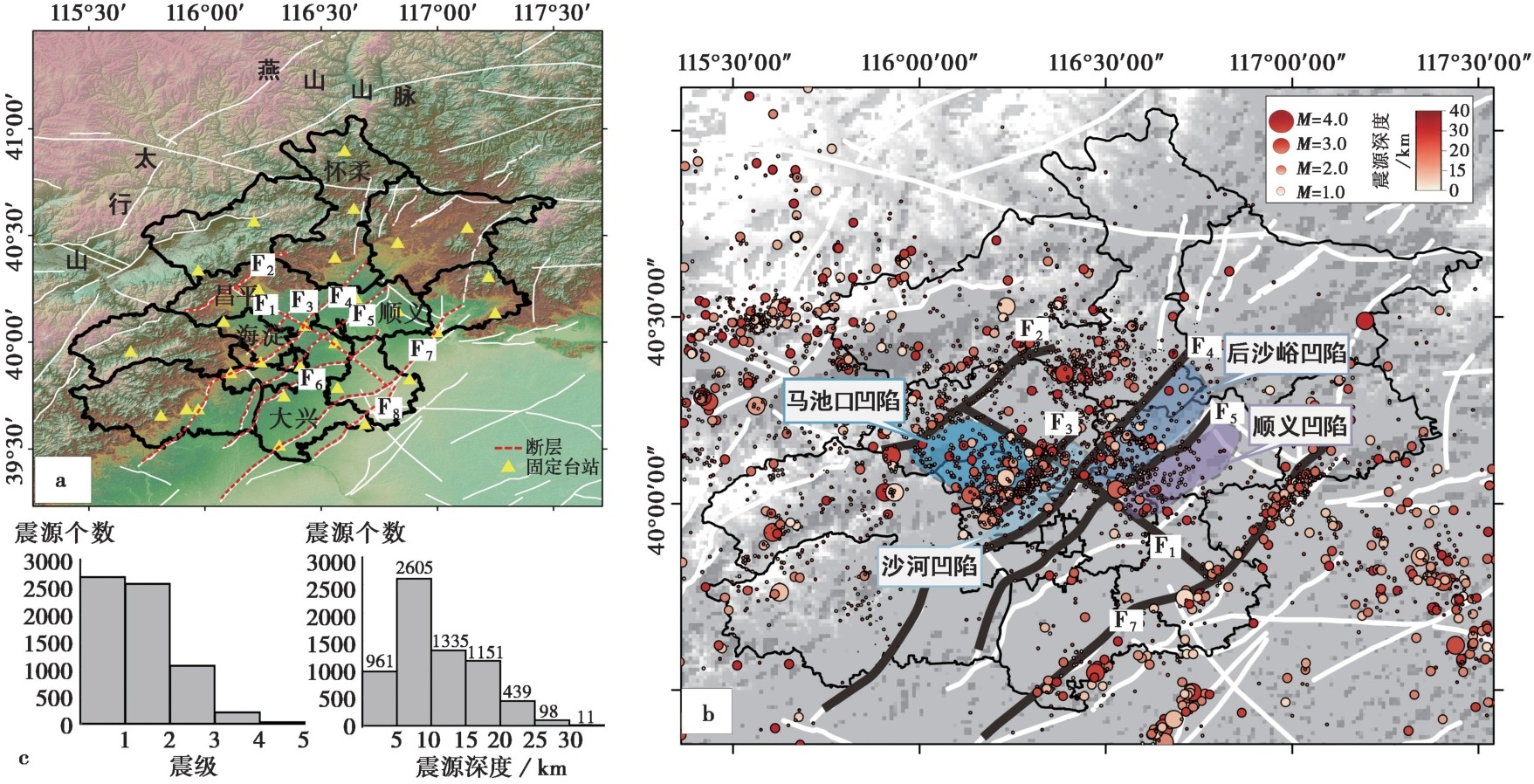
图1 北京地区地质构造及台站-震源分布图 a北京区域地质地形图, 红色线表示研究区域断裂: F1南口-孙河断裂; F2南口山前断裂; F3东北旺-小汤山断裂带; F4黄庄-高丽营断裂; F5顺义-良乡断裂; F6南苑-通县断裂; F7夏垫断裂; F8新夏垫断裂。b震源分布图。c震源深度与震级统计图
Fig. 1 Geological background and distribution of seismic stations and earthquakes in the Beijing region.
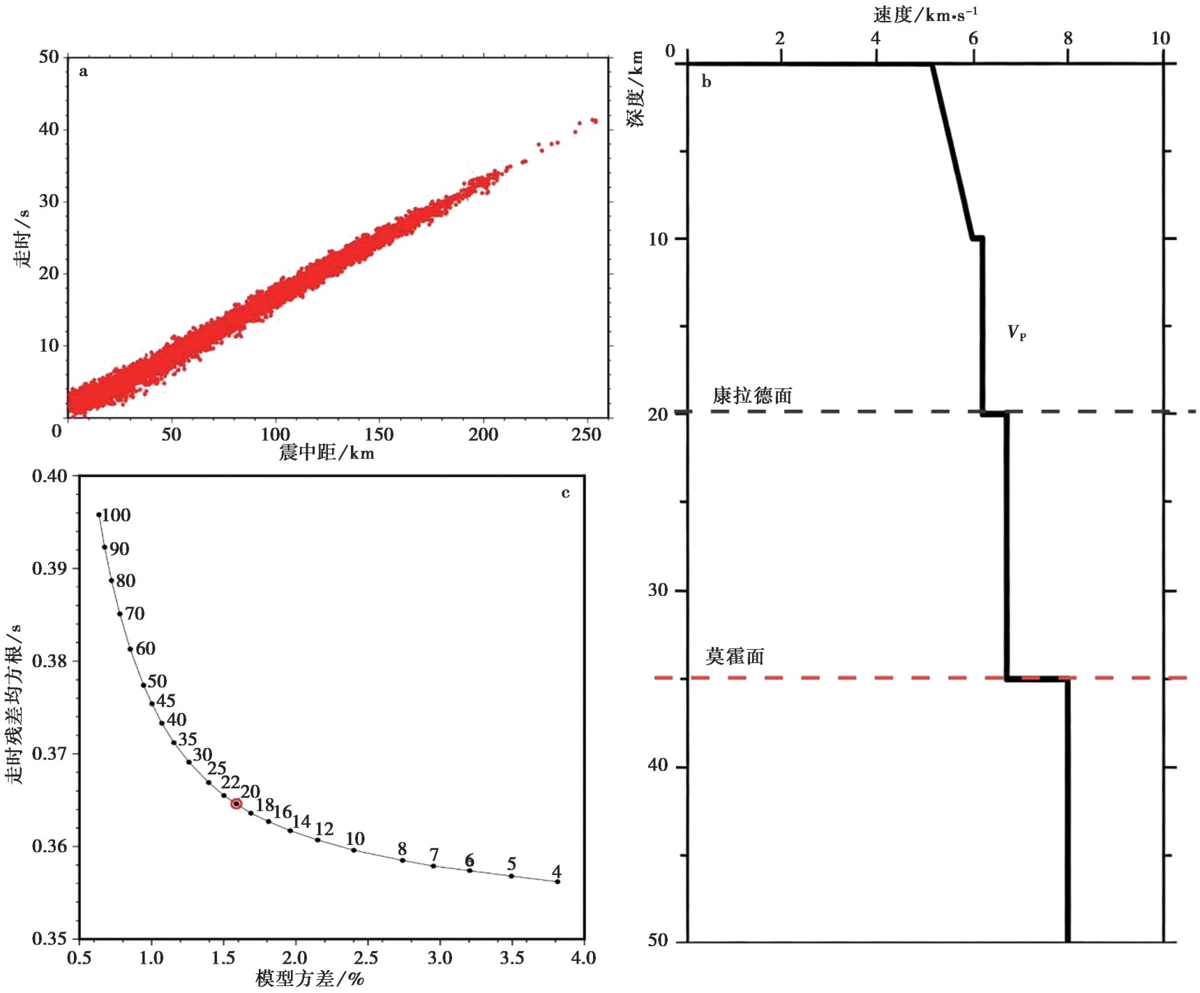
图2 走时数据散点图和反演参数 a P波时距曲线; b一维速度初始模型(引自黄金莉等(2005)); c阻尼系数折衷曲线。红点代表最佳阻尼系数
Fig. 2 Travel-time data scatter plot and inversion parameters.
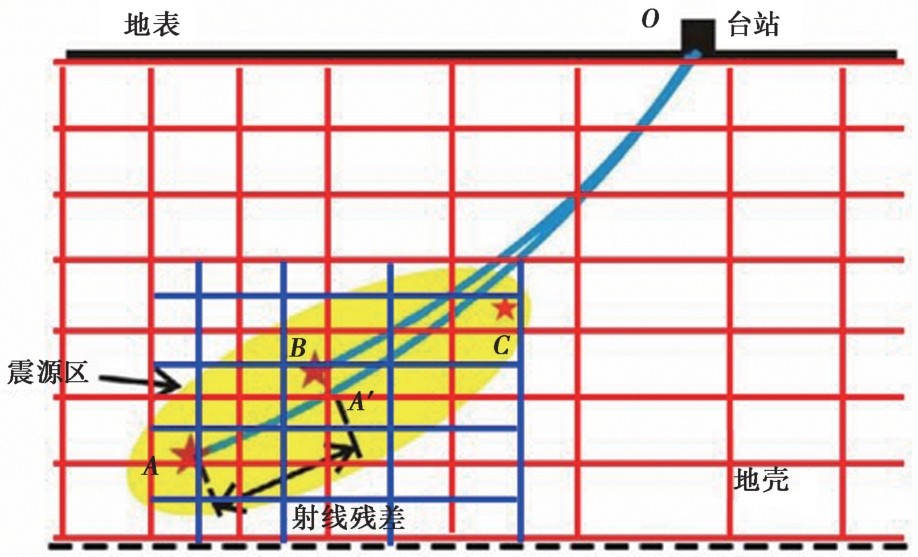
图3 小尺度双差成像方法原理示意图
Fig. 3 Schematic diagram of the updated small-scale double-difference tomography method.
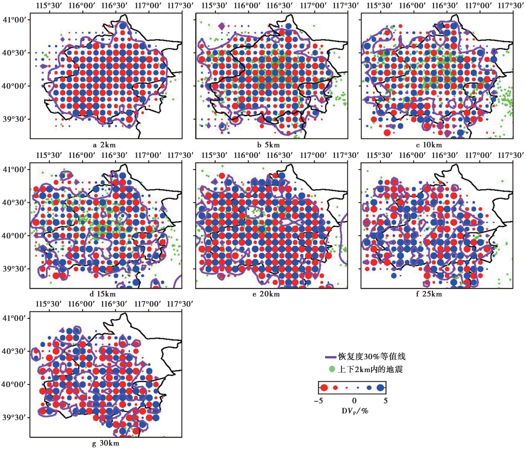
图4 绝对走时成像的检测板测试结果 绿色实心圆点代表水平层上、下2km范围内的地震; 红色和蓝色实心圆分别代表低速和高速异常; 紫色曲线代表分辨率恢复度为30%的等值线
Fig. 4 Results of a checkerboard resolution test by absolute travel-time tomography.
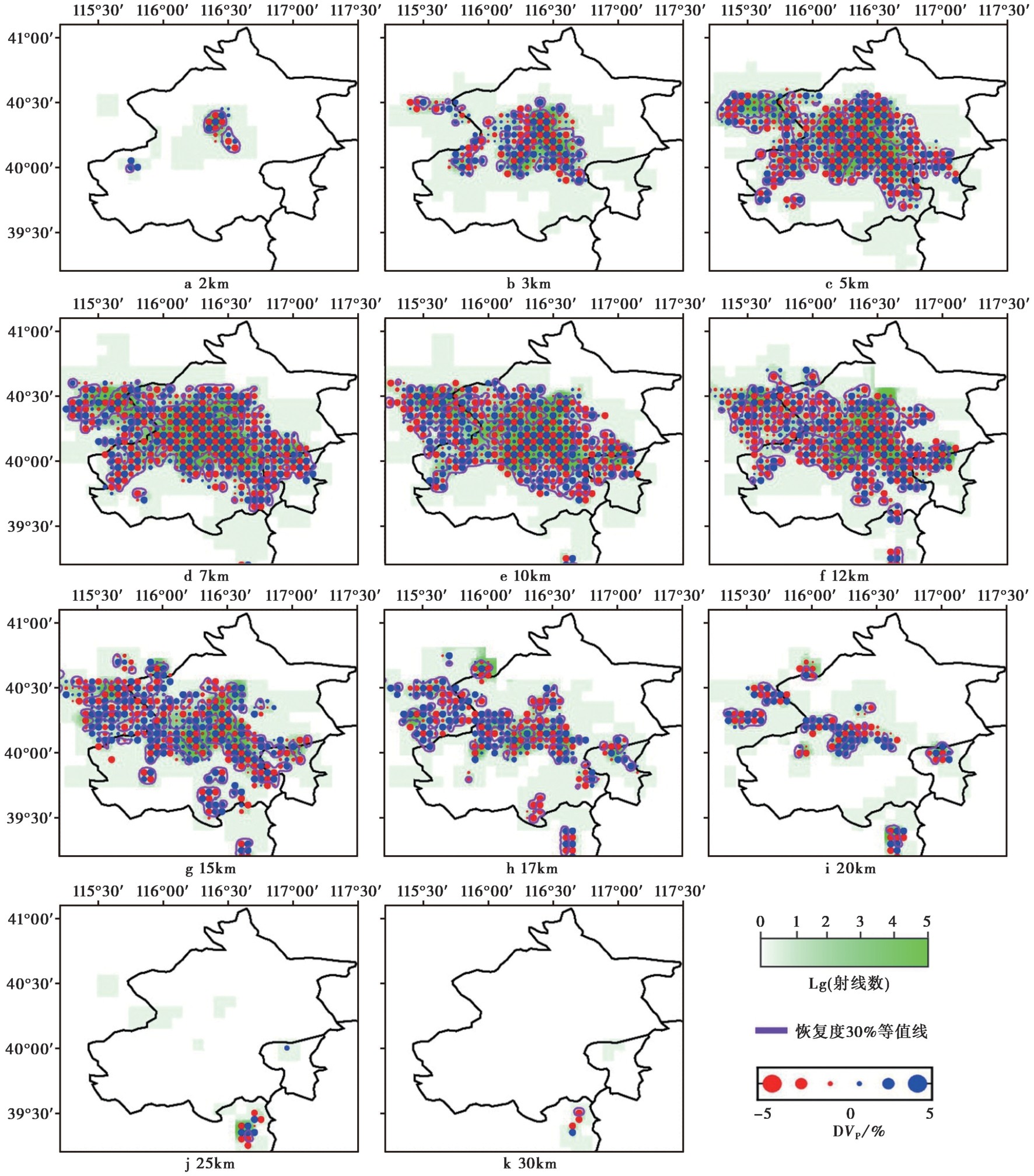
图5 震源区小尺度双差走时检测板测试结果 绿色色棒代表经过网格节点的射线数(以对数表示); 紫色曲线代表分辨率恢复度为30%的等值线
Fig. 5 Results of a checkerboard resolution test by small-scale double-difference tomography.
| MINWGHT | MAXDIST | MAXSEP | MAXNGH | MINLINK | MINOBS | MAXOBS |
|---|---|---|---|---|---|---|
| 0.01 | 400 | 10 | 8 | 8 | 8 | 100 |
表1 双差地震定位参数选择
Table1 Parameters for double-difference relocation by using hypoDD
| MINWGHT | MAXDIST | MAXSEP | MAXNGH | MINLINK | MINOBS | MAXOBS |
|---|---|---|---|---|---|---|
| 0.01 | 400 | 10 | 8 | 8 | 8 | 100 |
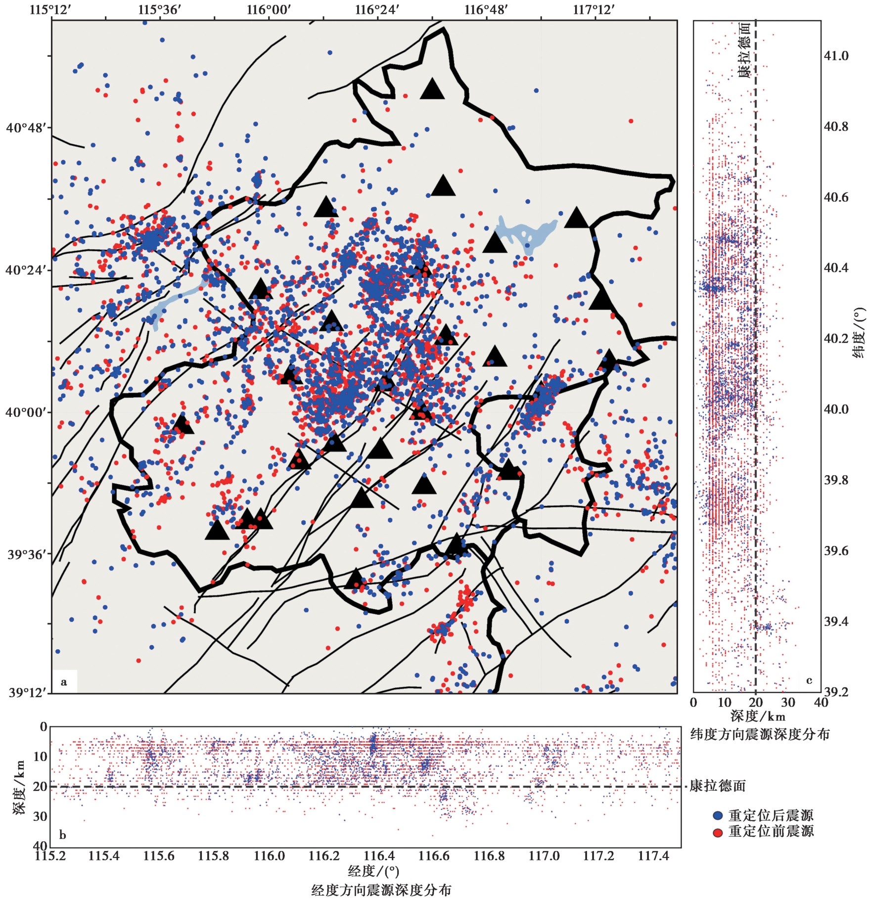
图6 震源定位前后对比 a震中分布; b沿经度方向的震源深度分布; c沿纬度方向的震源深度分布。红点和蓝点分别代表定位前和定位后的震源位置, 黑色三角形代表台站
Fig. 6 Comparison of hypocenter location of local events before and after relocation.
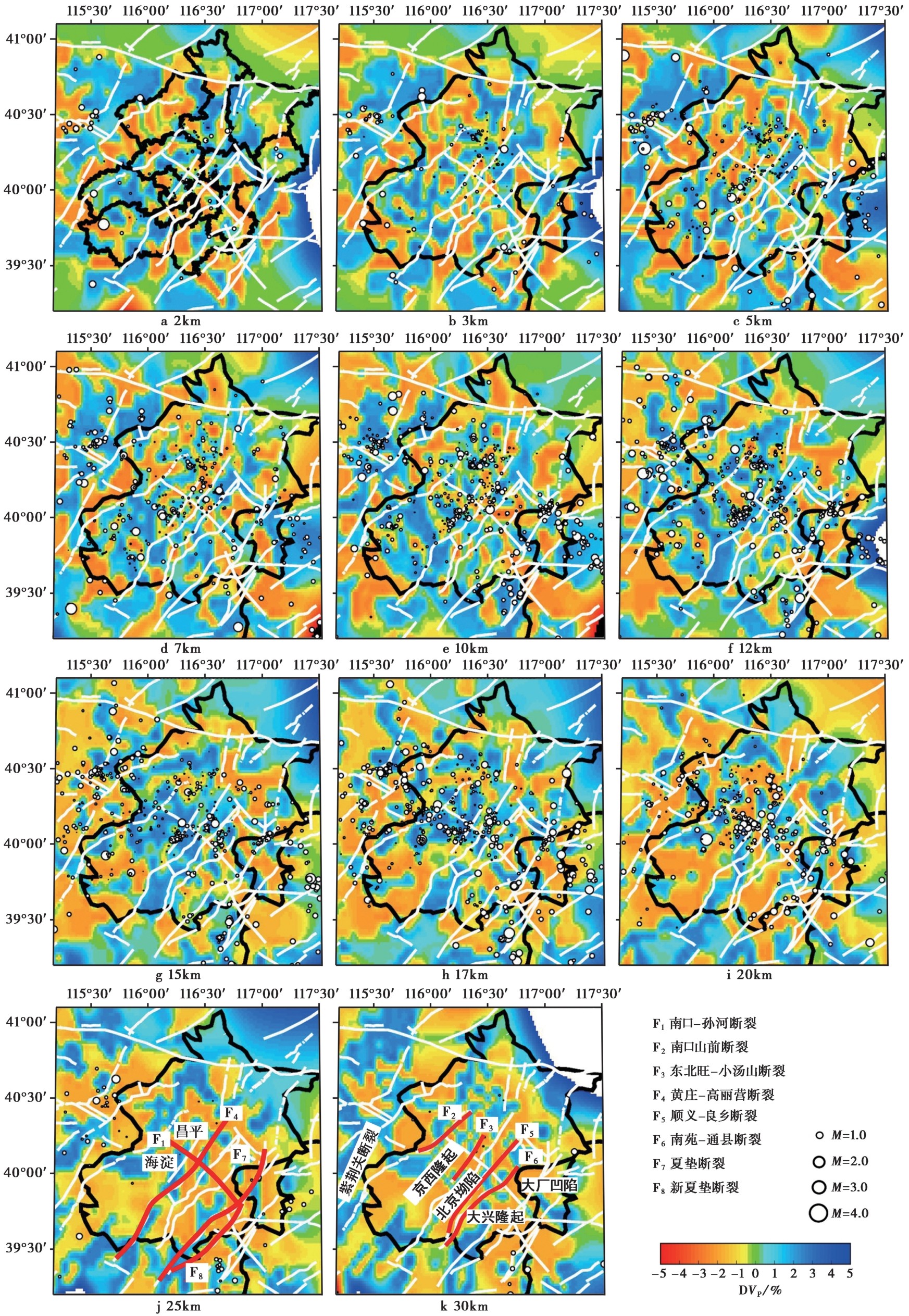
图7 三维P波速度水平剖面图 红色和蓝色分别代表低速和高速异常, 白色圆点代表距水平层±1km范围内的地震, 红色粗曲线代表主要断裂
Fig. 7 Plan views of 3-D P-wave velocity tomography.
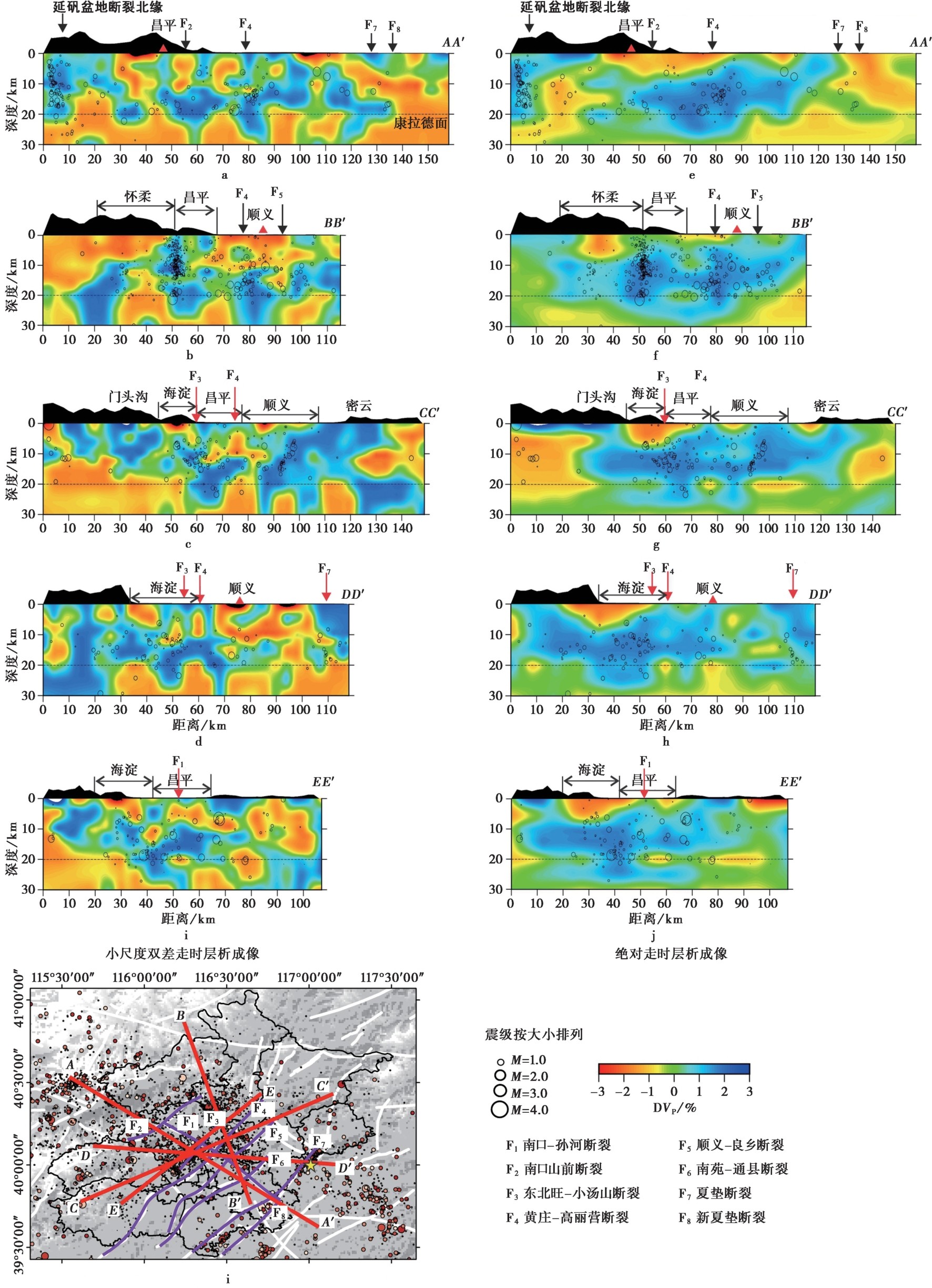
图8 沿剖线AA'-DD'的P波速度异常纵剖面图 a-d小尺度双差成像结果; e-h绝对走时成像结果。黑色圆圈代表距剖线2km范围内的地震, 圆圈大小代表震级, 红色和蓝色分别代表低速和高速异常; i剖线分布。紫色曲线代表主要断裂, 黄色五角星代表1679年三河8.0级大地震震中
Fig. 8 Vertical cross-sections of P-wave velocity tomography along four profiles AA' to DD'.
| [1] |
车用太, 王基华, 鱼金子, 等. 2001. 延怀盆地上地壳热流体特征及其与地震活动的关系[J]. 地震地质, 23(1): 49-54.
|
|
|
|
| [2] |
段永红, 王夫运, 张先康, 等. 2016. 华北克拉通中东部地壳三维速度结构模型(HBCrust1.0)[J]. 中国科学(地球科学), 46(6): 845-856.
|
|
|
|
| [3] |
宫猛, 邹献昆, 王晓山, 等. 2025. 京西北地区地壳速度结构与地震重新定位联合反演[J]. 地震地质, 47(4): 1132-1151. doi: 10.3969/j.issn.0253-4967.2025.04.20240014.
|
|
DOI |
|
| [4] |
黄金莉, 赵大鹏. 2005. 首都圈地区地壳三维P波速度细结构与强震孕育的深部构造环境[J]. 科学通报, 50(4): 348-355.
|
|
DOI URL |
|
| [5] |
黄雪源, 杨顶辉, 童平, 等. 2021. 首都圈地壳结构的拟波形层析成像研究[J]. 中国科学(地球科学), 51(1): 103-119.
|
|
|
|
| [6] |
刘晏廷, 钟成城, 江国明, 等. 2024. 西北太平洋板块边缘俯冲特征: 来自堪察加壳幔速度成像的约束[J]. CT理论与应用研究, 33(2): 135-148.
|
|
|
|
| [7] |
马寅生, 崔盛芹, 赵越, 等. 2002. 华北北部中新生代构造体制的转换过程[J]. 地质力学学报, 8(1): 15-25.
|
|
|
|
| [8] |
齐诚, 赵大鹏, 陈颙, 等. 2006. 首都圈地区地壳P波和S波三维速度结构及其与大地震的关系[J]. 地球物理学报, 49(3): 805-815.
|
|
|
|
| [9] |
孙佳珺, 孟勇琦, 谭晓迪, 等. 2022. 基于地貌单元的北京地区场地VS30 分类研究[J]. 地震工程与工程振动, 42(6): 246-252.
|
|
|
|
| [10] |
王椿镛, 吴庆举, 段永红, 等. 2017. 华北地壳上地幔结构及其大地震深部构造成因[J]. 中国科学(地球科学), 47(6): 684-719.
|
|
|
|
| [11] |
王惠卿, 谭成轩, 丰成君, 等. 2022. 京津冀协同发展区活动构造与地壳稳定性[J]. 地质通报, 41(8): 1322-1341.
|
|
|
|
| [12] |
汪万红. 2008. 秦岭北缘断裂带深部流体特征与区域地震活动的关系研究[D]. 兰州: 中国地震局兰州地震研究所.
|
|
|
|
| [13] |
夏心茹, 江国明, 赵大鹏. 2025. 郯庐断裂中南段地壳速度结构与地震活动性研究[J]. CT理论与应用研究, 34(2): 1-12.
|
|
|
|
| [14] |
于湘伟, 陈运泰, 张怀. 2010. 京津唐地区地壳三维P波速度结构与地震活动性分析[J]. 地球物理学报, 53(8): 1817-1828.
|
|
|
|
| [15] |
张先康, 赵金仁, 刘国华, 等. 2002. 三河-平谷8.0级大震区震源细结构的深地震反射探测研究[J]. 中国地震, 18(4): 326-336.
|
|
|
|
| [16] |
赵金仁, 张先康, 张成科, 等. 2004. 利用宽角反射/折射和深反射探测剖面揭示三河-平谷大震区深部结构特征[J]. 地球物理学报, 47(4): 646-653.
|
|
DOI URL |
|
| [17] |
钟世军, 王治国, 司政亚, 等. 2022. 北京地区小震精定位结果初步探讨[J]. 中国地震, 38(3): 513-525.
|
|
|
|
| [18] |
DOI URL |
| [19] |
DOI URL |
| [20] |
DOI URL |
| [21] |
|
| [22] |
DOI URL |
| [23] |
DOI URL |
| [24] |
DOI URL |
| [25] |
DOI |
| [26] |
DOI URL |
| [27] |
DOI URL |
| [28] |
|
| [29] |
DOI URL |
| [30] |
PMID |
| [31] |
DOI URL |
| [32] |
DOI |
| [1] | 王宏伟, 刘巧霞, 林吉焱, 张允涛, 范振宇. 初至波层析成像揭示的北京地区浅层地壳结构[J]. 地震地质, 2026, 48(5): 1457-1478. |
| [2] | 田建慧, 赵帅, 郭文斌, 李大虎, 李占飞. 基于密集台阵F-J方法的京西北平原区浅部速度结构特征[J]. 地震地质, 2026, 48(5): 1479-1496. |
| [3] | 王鑫, 高敏, 乔计花, 向健斌, 徐雨晨, 樊继迪. 郯庐断裂带中段重力均衡及深部孕震环境[J]. 地震地质, 2026, 48(3): 741-756. |
| [4] | 付俊东, 吴海英, 张建民, 鹿子林, 夏暖, 李志恒, 王雷, 邹奇峰. 郯庐断裂带安丘-莒县断裂南流段晚第四纪活动特征[J]. 地震地质, 2026, 48(3): 757-773. |
| [5] | 江宁波, 李大虎, 左洪, 王朝亮, 高咪, 易桂喜, 陈学芬. 川南荣县—威远—资中地区三维S波速度结构与地震活动特征[J]. 地震地质, 2026, 48(3): 830-852. |
| [6] | 李细兵, 陶小三, 顾勤平, 彭小波, 王宇, 朱峰. 郯庐断裂带中南段地壳上地幔顶部P波速度结构及其构造意义[J]. 地震地质, 2026, 48(2): 423-441. |
| [7] | 戴宗辉, 曲均浩, 徐宁, 李翠芹, 李冬梅, 尹玉振. 2023年微山震群震源区三维速度结构与发震构造[J]. 地震地质, 2025, 47(6): 1649-1666. |
| [8] | 李婷婷, 缪发军, 孙业君, 范文华, 宫杰, 顾勤平, 杜航, 孙小航, 张岑, 李子烨. 江苏江都震群震源区速度结构及构造特征[J]. 地震地质, 2025, 47(5): 1343-1363. |
| [9] | 张天继, 秦敏, 党文杰, 金明培, 李凤英, 杨黎薇. 接收函数与瑞利波相速度联合反演腾冲-保山地区的S波速度结构[J]. 地震地质, 2025, 47(5): 1364-1381. |
| [10] | 李若豪, 雷建设, 宋晓燕. 大同火山群及邻区三维地壳S波速度结构: 来自背景噪声面波直接成像约束[J]. 地震地质, 2025, 47(4): 1090-1112. |
| [11] | 杨建文, 金明培, 叶泵, 茶文剑, 黑贺堂. 基于背景噪声成像方法研究滇西北中上地壳三维速度结构及孕震环境[J]. 地震地质, 2025, 47(4): 1113-1131. |
| [12] | 宫猛, 邹献昆, 王晓山, 李广, 盛书中, 李红星, 徐荣华, 路昌胜. 京西北地区地壳速度结构与地震重新定位联合反演[J]. 地震地质, 2025, 47(4): 1132-1151. |
| [13] | 吉宇, 张广伟, 任俊杰, 何静, 王肖薇. 基于背景噪声成像研究北京地区三维S波速度结构[J]. 地震地质, 2025, 47(1): 306-324. |
| [14] | 冯策, 宋秀青, 王仁涛, 刘昊岚. 基于背景噪声层析成像反演上海及邻区S波速度结构[J]. 地震地质, 2024, 46(6): 1374-1390. |
| [15] | 侯颉, 吴庆举, 余大新, 叶庆东. 阿尔山火山群面波层析成像[J]. 地震地质, 2024, 46(4): 893-915. |
| 阅读次数 | ||||||
|
全文 |
|
|||||
|
摘要 |
|
|||||