地震地质 ›› 2022, Vol. 44 ›› Issue (1): 1-19.DOI: 10.3969/j.issn.0253-4967.2022.01.001
张驰1)( ), 李智敏2), 任治坤1),*(), 刘金瑞1), 张志亮1), 武登云1)
收稿日期:2021-01-15
修回日期:2021-06-29
出版日期:2022-02-20
发布日期:2022-04-20
通讯作者:
任治坤
作者简介:张驰, 男, 1995年生, 2018年于中国地质大学(武汉)获地质学学士学位, 现为中国地震局地质研究所构造地质学专业在读硕士研究生, 研究方向为活动构造与构造地貌, E-mail: 1184239246@qq.com。
基金资助:
ZHANG Chi1)(), LI Zhi-min2), REN Zhi-kun1),*(), LIU Jin-rui1), ZHANG Zhi-liang1), WU Deng-yun1)
Received:2021-01-15
Revised:2021-06-29
Online:2022-02-20
Published:2022-04-20
Contact:
REN Zhi-kun
摘要:
青藏高原东北缘是青藏高原向NE扩展的最前缘, 是理解高原扩张的最佳场所。日月山断裂是青藏高原东北缘一条NNW走向的右旋走滑断裂, 对其开展活动性研究对于理解高原扩张有重要意义。目前对该断裂南段的晚第四纪活动性质研究较少, 对其晚第四纪的活动特征认识尚且不足。文中基于日月山断裂南段的野外考察资料, 通过高精度遥感影像解译并结合典型位错点无人机摄影测量等方法获得其精细的几何展布, 根据断裂的展布特征自北向南将日月山断裂南段分为贵德和多禾茂2段。结合年代学研究, 初步确定日月山断裂南段存在全新世活动, 结合典型位错点多级地貌面定年与蒙特卡洛方法, 厘定了贵德段和多禾茂段全新世以来的水平滑动速率分别为(3.37+0.55/-0.68)mm/a和(2.69+0.41/-0.38)mm/a。结合前人的研究资料分析认为, 在NE向主应力下, 鄂拉山和日月山等断裂发生右旋走滑和NE向压扁, 共同吸收青藏高原东北缘块体NE向的地壳缩短。
中图分类号:
张驰, 李智敏, 任治坤, 刘金瑞, 张志亮, 武登云. 日月山断裂南段晚第四纪活动特征[J]. 地震地质, 2022, 44(1): 1-19.
ZHANG Chi, LI Zhi-min, REN Zhi-kun, LIU Jin-rui, ZHANG Zhi-liang, WU Deng-yun. CHARACTERISTICS OF LATE QUATERNARY ACTIVITY OF THE SOUTHERN RIYUESHAN FAULT[J]. SEISMOLOGY AND GEOLOGY, 2022, 44(1): 1-19.

图 1 青藏高原东北缘区域构造简图
Fig. 1 Simplified tectonic map of the northeast margin of the Tibetan plateau.
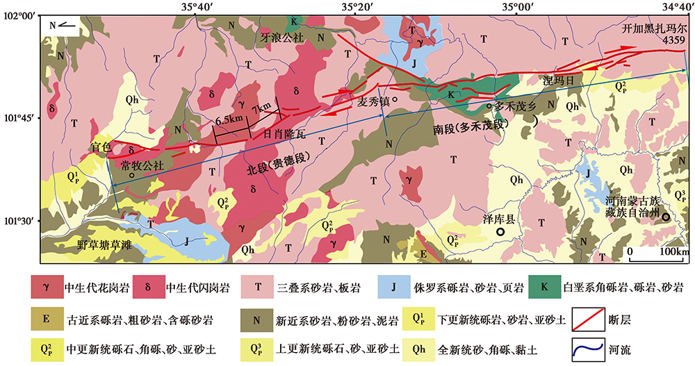
图 2 日月山断裂南段地质图
Fig. 2 Geological map of the southern section of Riyueshan Fault.
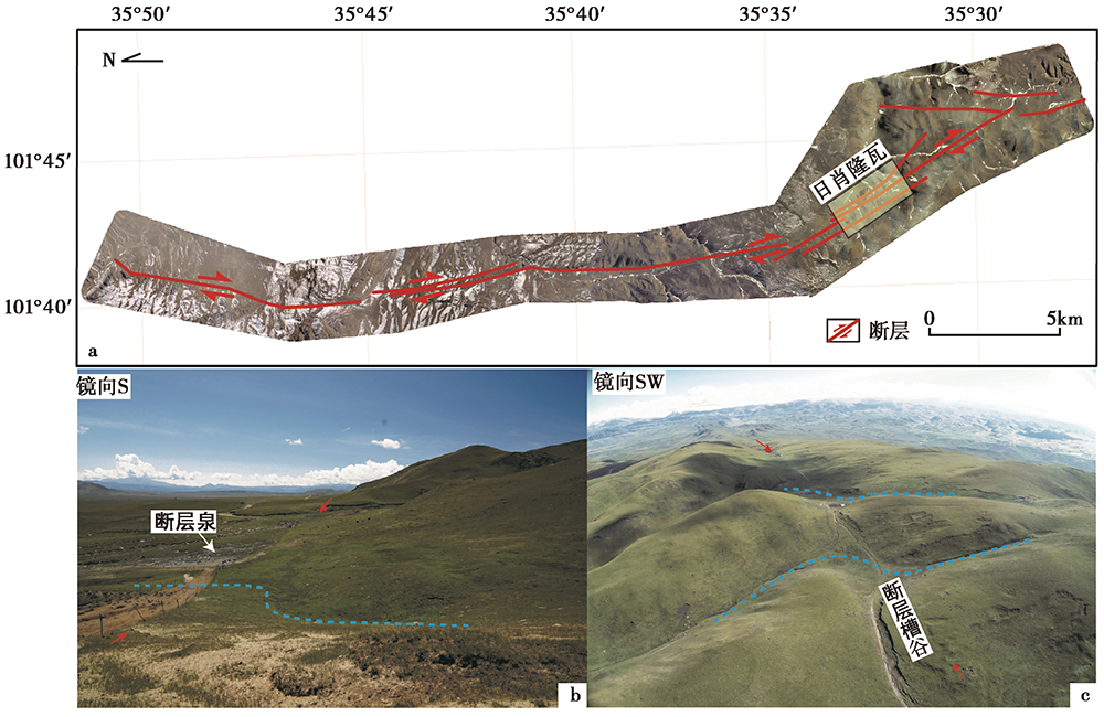
图 3 日月山断裂南段贵德段断层的精细几何展布及地貌特征
Fig. 3 Active fault geometry and geomorphological characteristics of the Guide section of the southern section of the Riyueshan Fault.
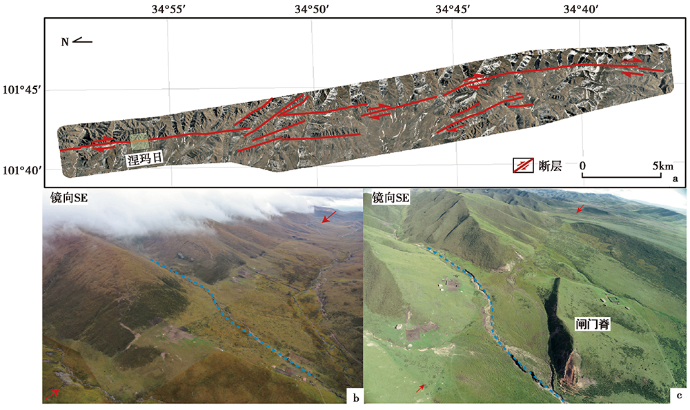
图 4 日月山断裂南段多禾茂段的精细几何结构及地貌特征
Fig. 4 Active fault geometry and geomorphological characteristics of the Duohemao section of the southern section of the Riyueshan Fault.

图 5 基岩断层剖面
Fig. 5 Bedrock section of the fault.
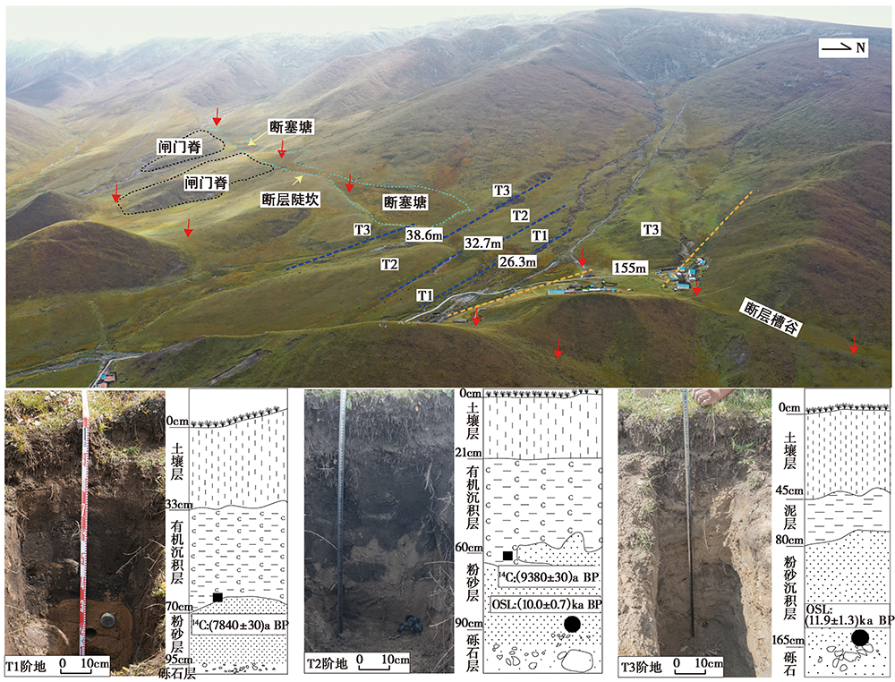
图 6 日肖隆瓦研究区的断错地貌特征、 采样剖面野外照片与素描
Fig. 6 Field photos and sketches showing the faulted landform and sampling sites at the Rixiaolongwa study area.
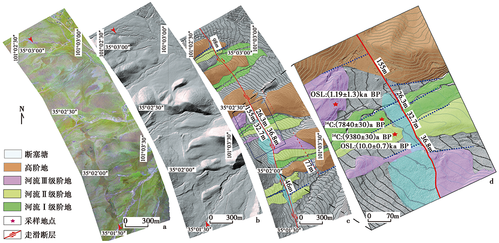
图 7 日肖隆瓦研究区基于高分辨率无人机航测DEM的断错地貌解译图
Fig. 7 Interpretation of faulted landform of the Rixiaolongwa study area based on UAV-derived high-resolution DEM.
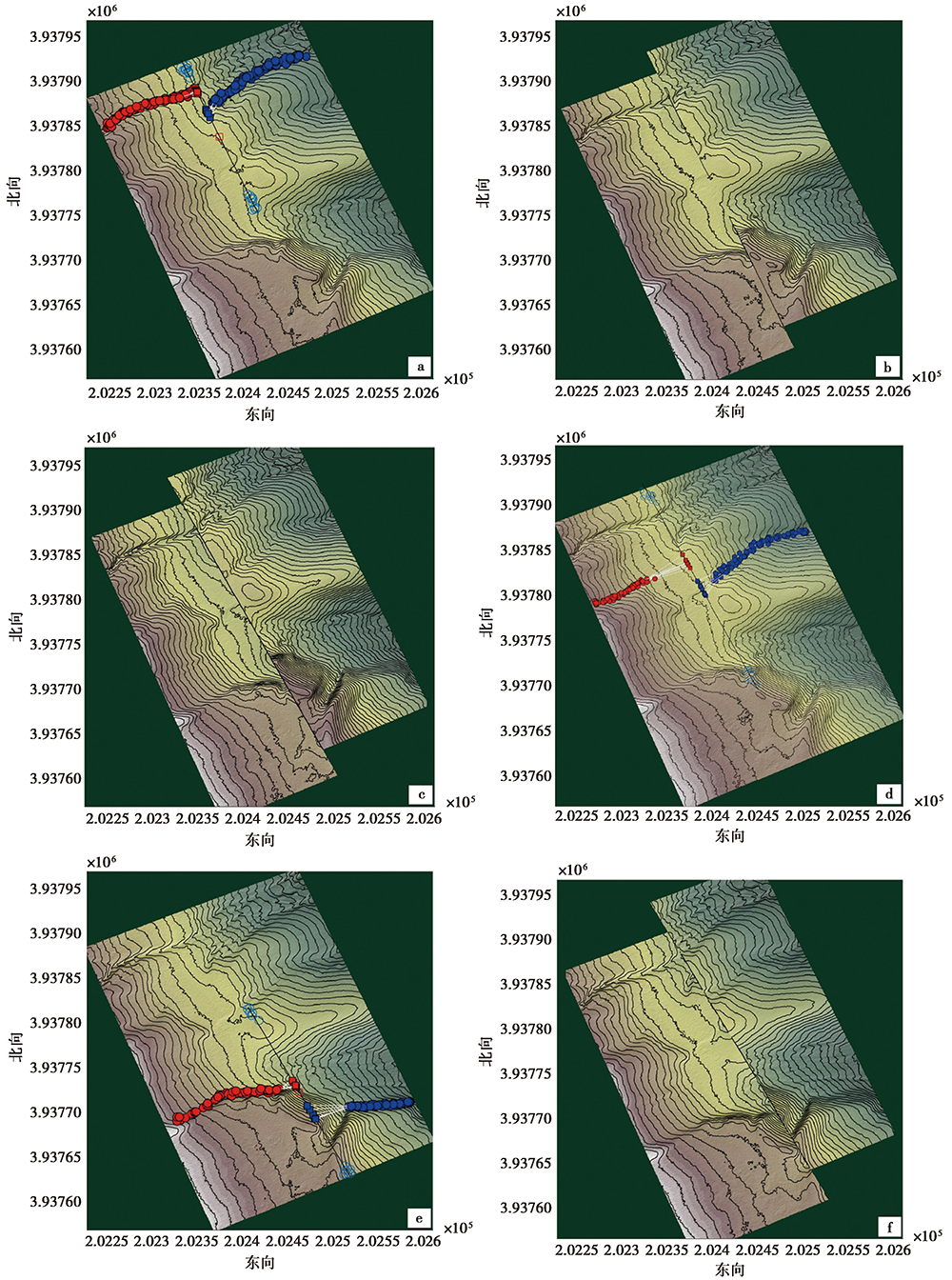
图 8 日肖隆瓦研究区基于LaDiCaoz_v2软件的河流阶地位错测量与恢复
Fig. 8 Measurement and backslip of the displaced terrace risers in the Rixiaolongwa study area based on LaDiCaoz_v2 software.
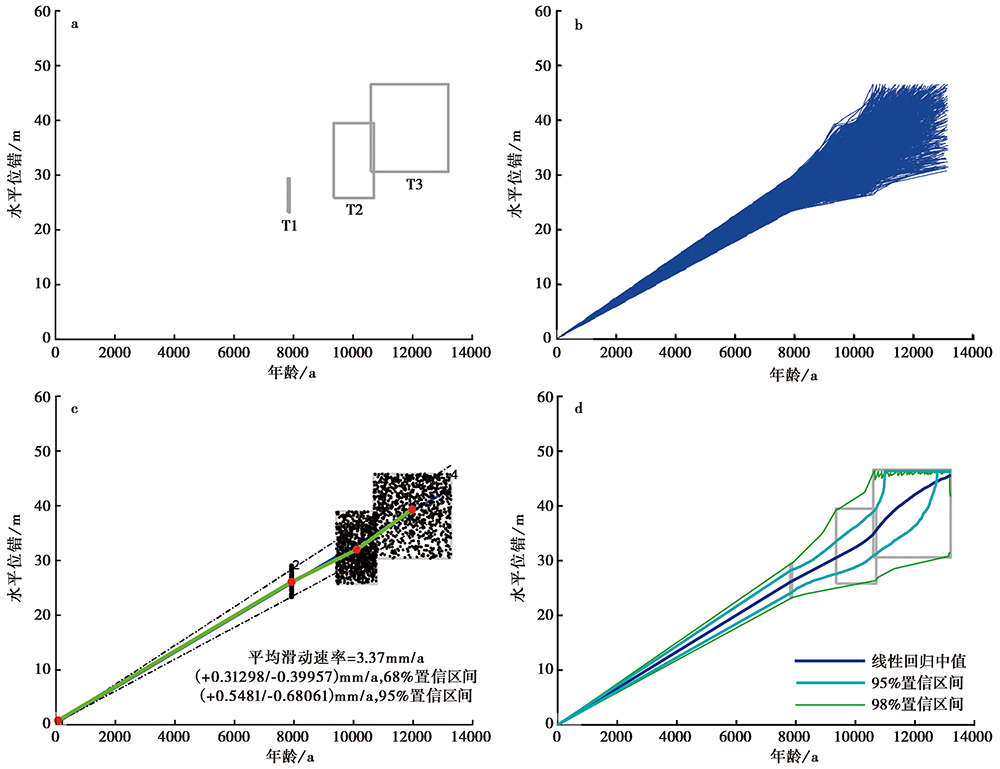
图 9 基于蒙特卡洛方法模拟的日肖隆瓦研究区的滑动速率
Fig. 9 The slip rate of Rixiaolongwa area based on Monte Carlo method.
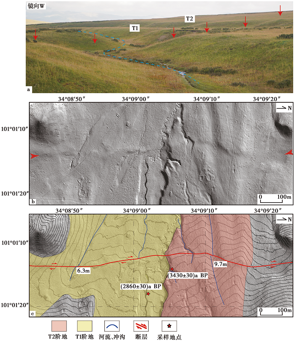
图 10 涅玛日研究区断错地貌的野外照片、 无人机DEM及解译图
Fig. 10 Fault geometry and faulted landform of the Niemari study area based on field photo and high-resolution UAV-derived DEM.

图 11 涅玛日研究区的采样及最新断错剖面
Fig. 11 Sampling sites of the Nierima study area, indicating the occurrence of the most recent earthquake.
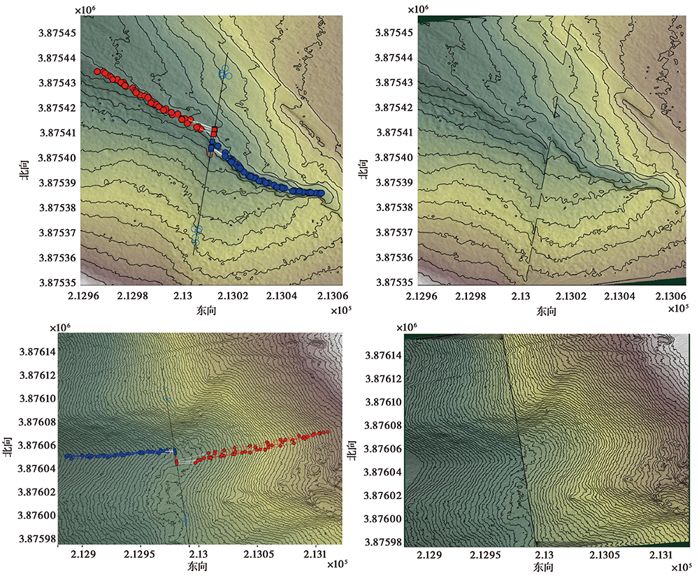
图 12 涅玛日研究区基于LaDiCaoz_v2软件的河流阶地位错测量与恢复
Fig. 12 The measurement and recovery of the riser offset in the Niemari study area based on LaDiCaoz_v2 software.
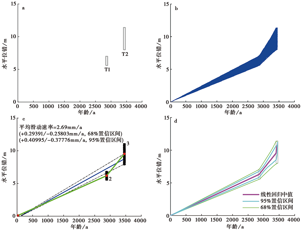
图 13 涅玛日研究区基于蒙特卡洛模拟滑动速率
Fig. 13 The slip rate of Niemari area based on Monte Carlo method.
| [1] | 艾明, 毕海芸, 郑文俊, 等. 2018. 利用无人机摄影测量技术提取活动构造定量参数[J]. 地震地质, 40(6): 1276-1293. |
| AI Ming, BI Hai-yun, ZHENG Wen-jun, et al. 2018. Using unmanned aerial vehicle photogrammetry technology to obtain quantitative parameters of active tectonics[J]. Seismology and Geology, 40(6): 1276-1293. (in Chinese) | |
| [2] | 邓起东. 2007. 中国活动构造图(1︰400万)[CM]. 北京: 地震出版社. |
| DENG Qi-dong. 2007. Map of Active Tectonics in China(1︰ 4 000 000)[CM]. Seismological Press, Beijing. (in Chinese) | |
| [3] | 邓起东, 陈立春, 冉勇康. 2004. 活动构造定量研究与应用[J]. 地学前缘, 11(4): 383-392. |
| DENG Qi-dong, CHEN Li-chun, RAN Yong-kang. 2004. Quantitative study and application of active tectonics[J]. Earth Science Frontiers, 11(4): 383-392. (in Chinese) | |
| [4] | 葛伟鹏, 王敏, 沈正康, 等. 2013. 柴达木-祁连山地块内部震间上地壳块体运动特征与变形模式研究[J]. 地球物理学报, 56(9): 2994-3010. |
| GE Wei-peng, WANG Min, SHEN Zheng-kang, et al. 2013. Interseismic kinematics and deformation patterns on the upper crust of Qaidam-Qilianshan block[J]. Chinese Journal of Geophysics, 56(9): 2994-3010. (in Chinese) | |
| [5] | 黄帅堂. 2016. 青海日月山断裂带地震危险性评价及其构造意义[D]. 北京: 中国地震局地震预测研究所. |
| HUANG Shuai-tang. 2016. Seismic hazard assessment of the Riyueshan fault zone in Qinghai and its tectonic significance[D]. Institute of Earthquake Forecasting, China Earthquake Administration, Beijing. (in Chinese) | |
| [6] | 简慧子, 王丽凤, 任治坤, 等. 2020. 基于GPS速度场研究鄂拉山断裂现今滑动速率和闭锁状态[J]. 地球物理学报, 63(3): 347-362. |
| JIAN Hui-zi, WANG Li-feng, REN Zhi-kun, et al. 2020. Present-day slip rate and interseismic fault coupling along the Elashan Fault using GPS[J]. Chinese Journal of Geophysics, 63(3): 347-362. (in Chinese) | |
| [7] | 李智敏, 苏鹏, 黄帅堂, 等. 2018. 日月山断裂德州段晚更新世以来的活动速率研究[J]. 地震地质, 40(3): 656-671. |
| LI Zhi-min, SU Peng, HUANG Shuai-tang, et al. 2018. Slip rates of the Riyue Mt. Fault at Dezhou segment since late Pleistocene[J]. Seismology and Geology, 40(3): 656-671. (in Chinese) | |
| [8] | 李智敏, 王强, 屠泓为. 2012. 热水-日月山断裂带遥感特征初步探讨[J]. 高原地震, 24(3): 16-22. |
| LI Zhi-min, WANG Qiang, TU Hong-wei. 2012. The remote sensing characteristic preliminary discussion on Reshui-Riyue Mountain fault zone[J]. Plateau Earthquake Research, 24(3): 16-22. (in Chinese) | |
| [9] | 刘金瑞, 任治坤, 张会平, 等. 2018. 海原断裂带老虎山段晚第四纪滑动速率精确厘定与讨论[J]. 地球物理学报, 61(4): 1281-1297. |
| LIU Jin-rui, REN Zhi-kun, ZHANG Hui-ping, et al. 2018. Late Quaternary slip rate of the Laohushan fault within the Haiyuan fault zone and its tectonic implications[J]. Chinese Journal of Geophysics, 61(4): 1281-1297. (in Chinese) | |
| [10] | 刘静, 陈涛, 张培震, 等. 2013. 机载激光雷达扫描揭示海原断裂带微地貌的精细结构[J]. 科学通报, 58(1): 41-45. |
| LIU Jing, CHEN Tao, ZHANG Pei-zhen, et al. 2013. Illuminating the active Haiyuan Fault, China by airborne light detection and ranging[J]. Chinese Science Bulletin, 58(1): 41-45. (in Chinese) | |
| [11] | 袁道阳, 张培震, 刘百篪, 等. 2004a. 青藏高原东北缘晚第四纪活动构造的几何图像与构造转换[J]. 地质学报, 78(2): 270-278. |
| YUAN Dao-yang, ZHANG Pei-zhen, LIU Bai-chi, et al. 2004a. Geometrical imagery and tectonic transformation of Late Quaternary active tectonics in northeastern margin of Qinghai-Xizang Plateau[J]. Acta Geologica Sinica, 78(2): 270-278. (in Chinese) | |
| [12] | 袁道阳, 张培震, 刘小龙, 等. 2004b. 青海鄂拉山断裂晚第四纪构造活动及其所反映的青藏高原东北缘的变形机制[J]. 地学前缘, 11(4): 393-403. |
| YUAN Dao-yang, ZHANG Pei-zhen, LIU Xiao-long, et al. 2004b. The tectonic activity and deformation features during the Late Quaternary of Elashan Mountain active fault zone in Qinghai Province and its implication for the deformation of the northeastern margins of the Qinghai-Tibet Plateau[J]. Earth Science Frontiers, 11(4): 393-403. (in Chinese) | |
| [13] | 张波. 2012. 西秦岭北缘断裂西段与拉脊山断裂新活动特征研究[D]. 兰州: 中国地震局兰州地震研究所. |
| ZHANG Bo. 2012. The study on the new activity characteristics of the western segment of the fault in the northern margin of West Qinling and the Lajishan Fault[D]. Lanzhou Institute of Seismology, China Earthquake Administration, Lanzhou. (in Chinese) | |
| [14] | 张培震, 李传友, 毛凤英. 2008. 河流阶地演化与走滑断裂滑动速率[J]. 地震地质, 30(1): 44-57. |
| ZHANG Pei-zhen, LI Chuan-you, MAO Feng-ying. 2008. Strath terrace formation and strike-slip faulting[J]. Seismology and Geology, 30(1): 44-57. (in Chinese) | |
| [15] | 张培震, 闵伟, 邓起东, 等. 2003. 海原活动断裂带的古地震与强震复发规律[J]. 中国科学(D辑), 33(8): 705-713. |
| ZHANG Pei-zhen, MIN Wei, DENG Qi-dong, et al. 2003. Recurrence regularity of paleoearthquakes and strong earthquakes in Haiyuan active fault zone[J]. Science in China(Ser D), 33(8): 705-713. (in Chinese) | |
| [16] | 赵保强. 2010. 青海省多禾茂地区SN向断裂特征及成因分析[D]. 北京: 中国地质大学. |
| ZHAO Bao-qiang. 2010. Characteristics and genesis analysis to the north-south faults in Duohemao area, Qinghai Province[D]. China University of Geosciences, Beijing. (in Chinese) | |
| [17] | 周德敏. 2005. 青藏高原东北缘现今地壳形变的GPS观测研究[D]. 北京: 中国地震局地质研究所. |
| ZHOU De-min. 2005. GPS observation of current crustal deformation in the northeast margin of Tibetan plateau[D]. Institute of Geology, China Earthquake Administration, Beijing. (in Chinese) | |
| [18] |
Bemis S P, Micklethwaite S, Turner D, et al. 2014. Ground-based and UAV-based photogrammetry: A multi-scale, high-resolution mapping tool for structural geology and paleoseismology[J]. Journal of Structural Geology, 69:163-178.
DOI URL |
| [19] |
Clark M K, Farley K A, Zheng D, et al. 2010. Early Cenozoic faulting of the northern Tibetan plateau margin from apatite(U-Th)/He ages[J]. Earth and Planetary Science Letters, 296(1-2): 78-88.
DOI URL |
| [20] |
Duvall A R, Clark M K. 2010. Dissipation of fast strike-slip faulting within and beyond northeastern Tibet[J]. Geology, 38(3): 223-226.
DOI URL |
| [21] |
Gold R D, Cowgill E. 2011. Deriving fault-slip histories to test for secular variation in slip, with examples from the Kunlun and Awatere faults[J]. Earth and Planetary Science Letters, 301(1-2): 52-64.
DOI URL |
| [22] |
Gold R D, Cowgill E, Arrowsmith J R, et al. 2016. Pulsed strain release on the Altyn Tagh Fault, northwest China[J]. Earth and Planetary Science Letters, 459:291-300.
DOI URL |
| [23] |
Liu J R, Ren Z K, Zheng W J, et al. 2020. Late Quaternary slip rate of the Aksay segment and its rapidly decreasing gradient along the Altyn Tagh Fault[J]. Geosphere, 16(6): 1538-1557.
DOI URL |
| [24] |
Mandl G. 1987. Tectonic deformation by rotating parallel faults: The bookshelf mechanism[J]. Tectonophysics, 141(4): 277-316.
DOI URL |
| [25] |
Meyer B, Tapponnier P, Bourjot L, et al. 1998. Crustal thickening in Gansu-Qinghai, lithospheric mantle subduction, and oblique, strike-slip controlled growth of the Tibet plateau[J]. Geophysical Journal International, 135(1): 1-47.
DOI URL |
| [26] | Ren Z K, Zhang Z Q, Chen T, et al. 2016. Clustering of offsets on the Haiyuan Fault and their relationship to paleoearthquakes[J]. Geological Society of America Bulletin, 128(1-2): 3-18. |
| [27] | Ren Z K, Zhang Z Q, Zhang P Z. 2018a. Different earthquake patterns for two neighboring fault segments within the Haiyuan fault zone[J]. Earth and Planetary Physics, 2(1): 67-73. |
| [28] |
Ren Z K, Zielke O, Yu J X. 2018b. Active tectonics in 4D high-resolution[J]. Journal of Structural Geology, 117:264-271.
DOI URL |
| [29] |
Tapponnier P, Xu Z Q, Roger F, et al. 2001. Oblique stepwise rise and growth of the Tibet Plateau[J]. Science, 294(5547): 1671-1677.
PMID |
| [30] |
van der Woerd J, Ryerson F J, Tapponnier P, et al. 1998. Holocene left-slip rate determined by cosmogenic surface dating on the Xidatan segment of the Kunlun Fault(Qinghai, China)[J]. Geology, 26(8): 695-698.
DOI URL |
| [31] | Wang S Y, Jiao R H, Ren Z K, et al. 2020. Active thrusting in an intermontane basin: The Kumysh Fault, eastern Tian Shan[J]. Tectonics, 39(8): 1-20. |
| [32] |
Wang S Y, Ren Z K, Wu C Y, et al. 2019. DEM generation from Worldview -2 stereo imagery and vertical accuracy assessment for its application in active tectonics[J]. Geomorphology, 336:107-118.
DOI URL |
| [33] |
Wang W, Zheng W J, Zhang P Z, et al. 2017. Expansion of the Tibetan plateau during the Neogene[J]. Nature Communications, 8(1): 1-12.
DOI URL |
| [34] |
Yvonne K, Hetzel R, Krbetschek M, et al. 2006. Holocene loess sedimentation along the Qilian Shan(China): Significance for understanding the processes and timing of loess deposition[J]. Quaternary Science Reviews, 25(1-2): 114-125.
DOI URL |
| [35] |
Yuan D Y, Champagnac J D, Ge W P, et al. 2011. Late Quaternary right-lateral slip rates of faults adjacent to the lake Qinghai, northeastern margin of the Tibetan plateau[J]. Geological Society of America Bulletin, 123(9-10): 2016-2030.
DOI URL |
| [36] |
Yuan D Y, Ge W P, Chen Z W, et al. 2013. The growth of northeastern Tibet and its relevance to large-scale continental geodynamics: A review of recent studies[J]. Tectonics, 32(5): 1358-1370.
DOI URL |
| [37] |
Zhang P Z, Burchfiel B C, Molnar P, et al. 1990. Late Cenozoic tectonic evolution of the Ningxia Hui Autonomous Region, China[J]. Geological Society of America Bulletin, 102(11): 1484-1498.
DOI URL |
| [38] |
Zhang P Z, Burchfiel B C, Molnar P, et al. 1991. Amount and style of late Cenozoic deformation in the Liupan Shan area, Ningxia Autonomous Region, China[J]. Tectonics, 10(6): 1111-1129.
DOI URL |
| [39] | Zhang P Z, Molnar P, Xu X W. 2007. Late Quaternary and present-day rates of slip along the Altyn Tagh Fault, northern margin of the Tibetan plateau[J]. Tectonics, 26(5): TC5010.1-TC5010.24. |
| [40] |
Zielke O, Arrowsmith J R. 2012. LaDiCaoz and LiDARimager: MATLAB GUIs for LiDAR data handling and lateral displacement measurement[J]. Geosphere, 8(1): 206-221.
DOI URL |
| [41] |
Zielke O, Arrowsmith J R, Ludwig L G, et al. 2010. Slip in the 1857 and earlier large earthquakes along the Carrizo Plain, San Andreas Fault[J]. Science, 327(5969): 1119-1122.
DOI PMID |
| [42] |
Zuza A V, Yin A. 2016. Continental deformation accommodated by non-rigid passive bookshelf faulting: An example from the Cenozoic tectonic development of northern Tibet[J]. Tectonophysics, 677-678:227-240.
DOI URL |
| [1] | 常玉巧, 张会平, 赵旭东. 青藏高原东南缘小江断裂带晚第四纪活动性研究进展[J]. 地震地质, 2026, 48(2): 279-313. |
| [2] | 徐伟, 李光涛, 程理, 邹子南. 毛毛山南缘断裂石板沟至南泥湾一带晚第四纪活动特征[J]. 地震地质, 2026, 48(2): 386-402. |
| [3] | 陈艳文, 袁道阳, 姚赟胜, 于锦超, 文亚猛, 苏瑞欢, 孙浩. 祁连山东段玛雅雪山断裂晚第四纪活动特征及其构造意义[J]. 地震地质, 2025, 47(6): 1566-1585. |
| [4] | 赵雪锋, 沈军, 巨广宏, 马飞朋, 赵文刚, 宋旭. 哈密盆地北缘断裂东段晚第四纪活动性[J]. 地震地质, 2025, 47(5): 1477-1493. |
| [5] | 黄婷, 吴芳, 夏彩香, 李振宏, 董晓朋, 吴中海, 寇琳琳. 宁夏清水河盆地南部全新世灾变事件层特征及其与区域地震的关系[J]. 地震地质, 2025, 47(4): 1036-1057. |
| [6] | 高扬, 吴中海, 韩帅, 田婷婷. 2025年定日MS6.8地震发震断层(登么错断裂)晚第四纪垂直滑动速率[J]. 地震地质, 2025, 47(3): 689-706. |
| [7] | 王度, 陈立春, 李彦宝, 王虎, 贾永顺, 高茵怡, 薛柯依. 藏南申扎-定结裂谷系谢通门-登么错段晚第四纪活动特征[J]. 地震地质, 2025, 47(3): 718-733. |
| [8] | 陈长云, 尹海权. 新疆地区现今地壳变形特征与强震危险性概率预测[J]. 地震地质, 2025, 47(2): 384-404. |
| [9] | 朱爽, 郭南男, 庞亚瑾. 西南天山柯坪冲断带断层形变特征及地震危险性[J]. 地震地质, 2025, 47(2): 448-462. |
| [10] | 许斌斌, 张逸鹏, 卢乐浚, 田晴映, 杨雪, 王洋, 张培震. 2025年3月缅甸 MS7.9 地震的发震构造[J]. 地震地质, 2025, 47(2): 649-670. |
| [11] | 花春雨, 石峰, 魏占玉. 龙门山断裂带映秀-北川断裂白沙河段滑动速率[J]. 地震地质, 2024, 46(6): 1295-1313. |
| [12] | 陈柏旭, 余中元, 肖鹏, 戴训也, 张世龙, 郑荣荧. 青藏高原东北缘榆木山东缘断裂地表破裂带的新发现及其地震地质意义[J]. 地震地质, 2024, 46(3): 589-607. |
| [13] | 陈毅, 赵斌, 熊维, 王伟, 余鹏飞, 余建胜, 王东振, 陈威, 乔学军. InSAR数据约束的鲜水河断裂带北西段震间滑动速率及浅部蠕滑特征[J]. 地震地质, 2023, 45(5): 1074-1091. |
| [14] | 左玉琦, 杨海波, 杨晓平, 詹艳, 李安, 孙翔宇, 胡宗凯. 阿拉善地块南缘北大山断裂的晚第四纪构造活动证据[J]. 地震地质, 2023, 45(2): 355-376. |
| [15] | 杨源源, 李鹏飞, 路硕, 疏鹏, 潘浩波, 方良好, 郑海刚, 赵朋, 郑颖平, 姚大全. 郯庐断裂带中段F5断裂淮河-女山湖段的古地震与垂直滑动速率[J]. 地震地质, 2022, 44(6): 1365-1383. |
| 阅读次数 | ||||||
|
全文 |
|
|||||
|
摘要 |
|
|||||
