地震地质 ›› 2022, Vol. 44 ›› Issue (2): 297-312.DOI: 10.3969/j.issn.0253-4967.2022.02.002
叶雨晖1)( ), 吴磊1),*(), 王依平1), 楼谦谦2), 陈力琦3), 高石宝1), 林秀斌1), 程晓敢1), 陈汉林1)
收稿日期:2021-02-25
修回日期:2021-06-15
出版日期:2022-04-20
发布日期:2022-06-14
通讯作者:
吴磊
作者简介:叶雨晖, 女, 1995年生, 2021年于浙江大学获构造地质学专业硕士学位, 主要研究方向为青藏高原新生代构造演化, E-mail: yeyuhui007@163.com。
基金资助:
YE Yu-hui1)(), WU Lei1),*(), WANG Yi-ping1), LOU Qian-qian2), CHEN Li-qi3), GAO Shi-bao1), LIN Xiu-bin1), CHENG Xiao-gan1), CHEN Han-lin1)
Received:2021-02-25
Revised:2021-06-15
Online:2022-04-20
Published:2022-06-14
Contact:
WU Lei
摘要:
位于青藏高原和塔里木盆地之间的北阿尔金断裂是青藏高原向N扩展的重要边界条件, 目前对其新生代以来的运动学特征还存在较大争议。文中利用DEM数据提取了穿过北阿尔金断裂的18条河流及相关汇水盆地的地貌信息, 分析了河流平、 纵剖面的形态、 标准化河流长度坡度指数(SLK)、 标准化河流陡峭指数(Ksn)以及汇水盆地面积-高程曲线和积分(HI)等多个构造地貌指标参数, 以研究北阿尔金断裂晚第四纪以来的活动性和活动方式。结果表明, 北阿尔金断裂西段的河流纵剖面和汇水盆地面积-高程曲线呈上凹型, 河流纵剖面上发育较多小规模的裂点, SLK、 Ksn和HI值相对较低。与之相反, 其东段的河流纵剖面大都呈上凸型和平直型, 在北阿尔金断裂上盘发育较大规模的河流裂点, 对应较高的SLK和Ksn值; 面积-高程曲线形态以S型和上凸型为主, HI值也相对较大。上述地貌指标反映北阿尔金断裂东段的地貌活动性较西段更强, 推测为东段正好位于南阿尔金断裂阿克图受阻双弯曲北侧, 受其强烈侧向挤压所致。此外, 河流穿过北阿尔金断裂没有发生系统的左旋位错, 新发现的一条错断晚第四纪冲积扇的前锋断裂也呈现出典型的逆冲特征, 表明北阿尔金断裂在晚第四纪以来以逆冲运动为主。结合前人的研究结果推测, 北阿尔金断裂在晚新生代存在从走滑向逆冲的构造转换, 且与南阿尔金断裂之间存在密切的相互作用。
中图分类号:
叶雨晖, 吴磊, 王依平, 楼谦谦, 陈力琦, 高石宝, 林秀斌, 程晓敢, 陈汉林. 北阿尔金断裂晚第四纪活动构造特征[J]. 地震地质, 2022, 44(2): 297-312.
YE Yu-hui, WU Lei, WANG Yi-ping, LOU Qian-qian, CHEN Li-qi, GAO Shi-bao, LIN Xiu-bin, CHENG Xiao-gan, CHEN Han-lin. LATE QUATERNARY ACTIVE TECTONICS OF THE NORTH ALTYN FAULT[J]. SEISMOLOGY AND GEOLOGY, 2022, 44(2): 297-312.
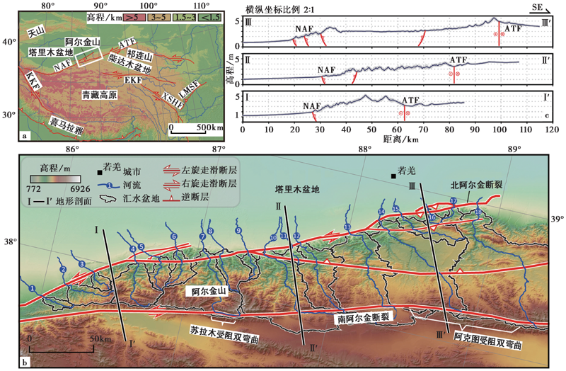
图 1 研究区的地形与主要断裂特征 a 青藏高原主要断裂和研究区(白色实线矩形框)的位置与范围, 构造线数据来自Taylor等(2009); b 研究区的主要断裂与水系分布; c 北阿尔金断裂的地形条带剖面(条带宽1km), 剖面位置如图1b所示。ATF 南阿尔金断裂; NAF 北阿尔金断裂; EKF 东昆仑断裂; XSHF 鲜水河断裂; KKF 喀喇昆仑断裂; LMSF 龙门山断裂带
Fig. 1 Topographic characteristics and major faults of the study area.
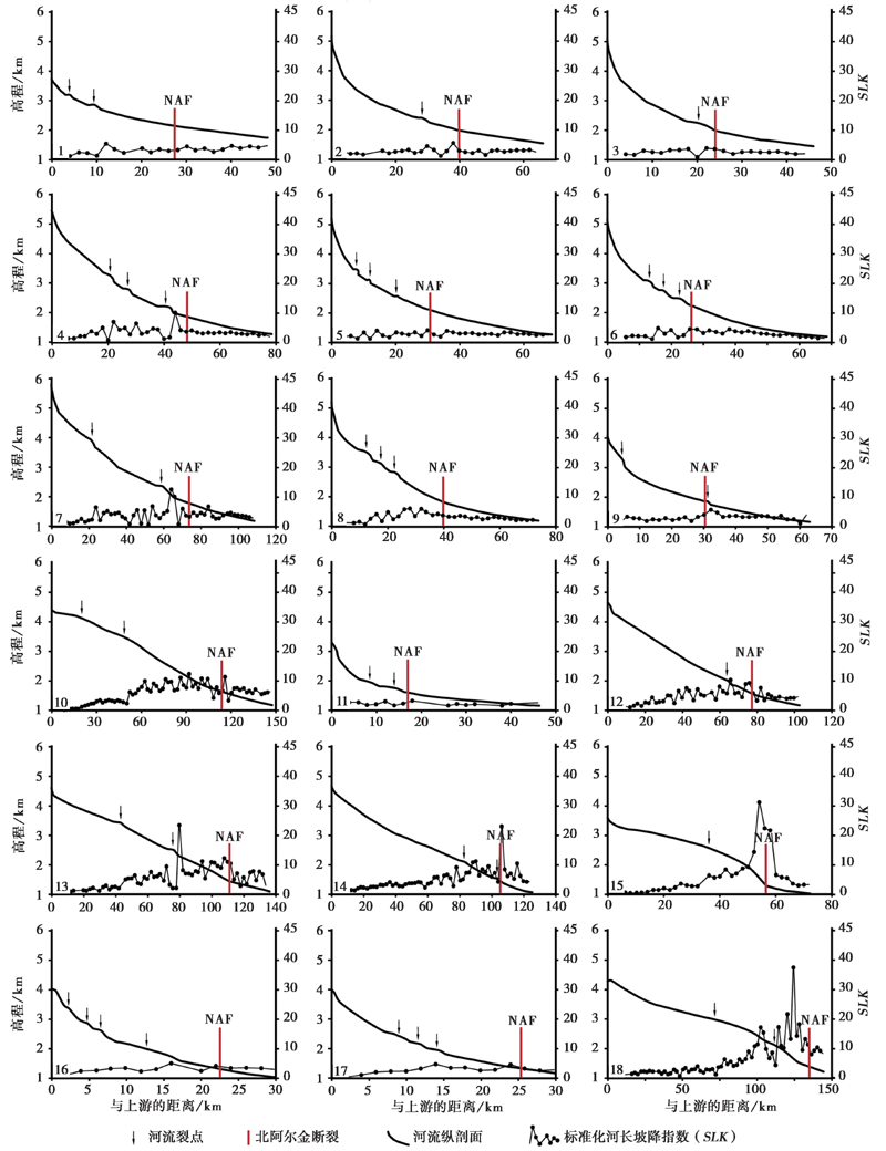
图 2 河流纵剖面与河流长度坡度指数(SLK)
Fig. 2 River longitudinal profiles and standardized river length-gradient index(SLK).
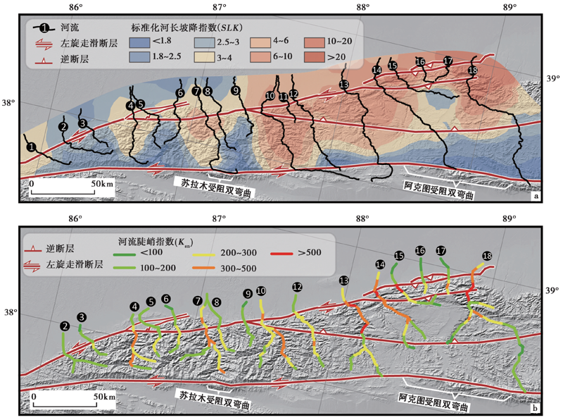
图 3 北阿尔金断裂地区的河流长度坡度指数(SLK)和河流陡峭指数(Ksn)平面图
Fig. 3 Plan of standardized river length-gradient index(SLK) and normalized river steepness index(Ksn)of North Altyn Fault area.
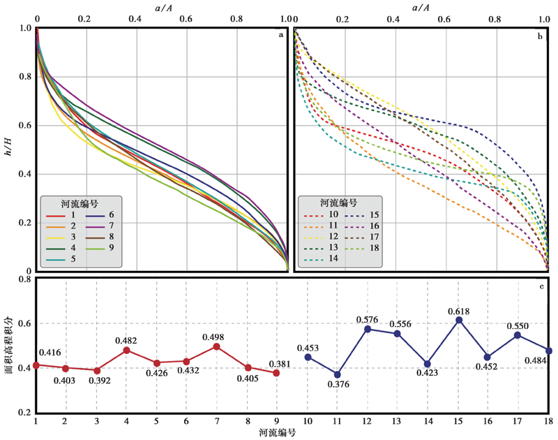
图 4 北阿尔金断裂地区18个汇水盆地的测高曲线及其积分
Fig. 4 Area-elevation curve and their integrals of 18 catchment basins in the North Altyn Fault area.
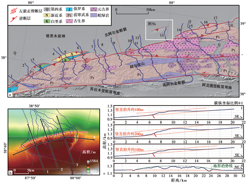
图 5 北阿尔金断裂的地质简图(a)及NAF北部前锋断裂的平面形态(b)和剖面形态(c)
Fig. 5 Geological map of North Altyn Fault(a), plane shape(b)and vertical shape(c)of northern NAF front fault.
| [1] | 崔军文. 1999. 阿尔金断裂系[M]. 北京: 地质出版社. |
| CUI Jun-wen. 1999. The Altyn tagh Fault System[M]. Geological Publishing House, Beijing. (in Chinese) | |
| [2] | 崔军文. 2011. 南阿尔金断裂的韧性剪切作用时代及其构造意义[J]. 岩石学报, 27(11): 3422-3434. |
| CUI Jun-wen. 2011. Ductile shearing age of the south Altun Fault and its tectonic implications[J]. Acta Petrologica Sinica, 27(11): 3422-3434. (in Chinese) | |
| [3] | 李海兵, 许志琴, 杨经绥, 等. 2007. 阿尔金断裂带最大累积走滑位移量: 900km?[J]. 地质通报, 26(10): 1288-1298. |
| LI Hai-bing, XU Zhi-qin, YANG Jing-sui,et al. 2007. The maximum cumulative strike-slip displacement of the Altyn Tagh Fault: 900km?[J]. Geological Bulletin of China, 26(10): 1288-1298. (in Chinese) | |
| [4] | 李海兵, 杨经绥, 许志琴, 等. 2006. 阿尔金断裂带对青藏高原北部生长、 隆升的制约[J]. 地学前缘, 13(4): 59-79. |
| LI Hai-bing, YANG Jing-sui, XU Zhi-qin,et al. 2006. The constraint of the Altyn Tagh fault system to the growth and rise of the northern Tibetan plateau[J]. Earth Science Frontiers, 13(4): 59-79. (in Chinese) | |
| [5] | 李雪梅, 张会平. 2017. 河流瞬时地貌: 特征、 过程及其构造-气候相互作用内涵[J]. 第四纪研究, 37(2): 416-430. |
| LI Xue-mei, ZHANG Hui-ping. 2017. Transient fluvial landscape: Features, processes and its implication for tectonic-climate interaction[J]. Quaternary Sciences, 37(2): 416-430. (in Chinese) | |
| [6] | 刘永江, Neubauer F, 葛肖虹, 等. 2007. 阿尔金断裂带年代学和阿尔金山隆升[J]. 地质科学, 42(1): 134-146. |
| LIU Yong-jiang, Neubauer F, GE Xiao-hong,et al. 2007. Geochronology of the Altun fault zone and rising of the Altun Mountains[J]. Journal of Geology, 42(1): 134-146. (in Chinese) | |
| [7] | 刘永江, 葛肖虹, Genser J, 等. 2003. 阿尔金断裂带构造活动的 40Ar/39Ar年龄证据[J]. 科学通报, 48(12): 1335-1341. |
| LIU Yong-jiang, GE Xiao-hong, Genser J,et al. 2003. 40Ar/39Ar age evidence of tectonic activity in Altun fault zone[J]. Chinese Science Bulletin, 48(12): 1335-1341. (in Chinese) | |
| [8] | 潘家伟, 李海兵, 孙知明, 等. 2015. 阿尔金断裂带新生代活动在柴达木盆地中的响应[J]. 岩石学报, 31(12): 3701-3712. |
| PAN Jia-wei, LI Hai-bing, SUN Zhi-ming,et al. 2015. Tectonic responses in the Qaidam Basin induced by Cenozoic activities of the Altyn Tagh Fault[J]. Acta Petrologica Sinica, 31(12): 3701-3712. (in Chinese) | |
| [9] | 邱江涛, 朱良玉, 王随随. 2018. 阿尔金断裂带中段现今构造形变模式的InSAR研究[J]. 大地测量与地球动力学, 38(8): 783-786. |
| QIU Jiang-tao, ZHU Liang-yu, WANG Sui-sui. 2018. Study on the contemporary tectonic deformation pattern of the middle Altyn Tagh fault zone as reveal by InSAR measurements[J]. Journal of Geodesy and Geodynamics, 38(8): 783-786. (in Chinese) | |
| [10] | 孙岳, 陈正乐, 陈柏林, 等. 2014. 阿尔金北缘EW向山脉新生代隆升剥露的裂变径迹证据[J]. 地球学报, 35(1): 67-75. |
| SUN Yue, CHEN Zheng-le, CHEN Bo-lin,et al. 2014. Cenozoic uplift and denudation of the EW-trending range of northern Altun Mountains: Evidence from apatite fission track data[J]. Acta Geoscientica Sinica, 35(1): 67-75. (in Chinese) | |
| [11] | 孙知明, 李海兵, 裴军令, 等. 2012. 阿尔金断裂走滑作用对青藏高原东北缘山脉形成的古地磁证据[J]. 岩石学报, 28(6): 1928-1936. |
| SUN Zhi-ming, LI Hai-bing, PEI Jun-ling,et al. 2012. Strike-slip movement of the Altyn Tagh Fault and implications for mountain formation inferred from paleomagnetic data in northeastern Tibetan plateau[J]. Acta Petrologica Sinica, 28(6): 1928-1936. (in Chinese) | |
| [12] | 王亚东, 郑建京, 孙国强, 等. 2015. 柴西北地区碎屑锆石裂变径迹年龄记录的阿尔金山早新生代隆升事件[J]. 吉林大学学报(地球科学版), 45(5): 1447-1459. |
| WANG Ya-dong, ZHENG Jian-jing, SUN Guo-qiang,et al. 2015. Early Cenozoic uplift of Altun Mountains recorded by detrital zircon fission track age in northwestern Qaidam Basin[J]. Journal of Jilin University(Earth Science Edition), 45(5): 1447-1459. (in Chinese) | |
| [13] | 肖安成, 吴磊, 李洪革, 等. 2013. 阿尔金断裂新生代活动方式及其与柴达木盆地的耦合分析[J]. 岩石学报, 29(8): 2826-2836. |
| XIAO An-cheng, WU Lei, LI Hong-ge,et al. 2013. Tectonic processes of the Cenozoic Altyn Tagh Fault and its coupling with the Qaidam Basin, NW China[J]. Acta Petrologica Sinica, 29(8): 2826-2836. (in Chinese) | |
| [14] | 徐锡伟, Tapponnier P, van der Woerd J, 等. 2003. 阿尔金断裂带晚第四纪左旋走滑速率及其构造运动转换模式讨论[J]. 中国科学(D辑), 33(10): 967-974. |
| XU Xi-wei, Tapponnier P, van der Woerd J,et al. 2003. Late Quaternary sinistral strike slip rate of Altyn Tagh fault zone and its tectonic transformation model[J]. Science in China(Ser D), 33(10): 967-974. (in Chinese) | |
| [15] | 张会平. 2006. 青藏高原东缘、 东北缘典型地区晚新生代地貌过程研究[D]. 北京: 中国地质大学. |
| ZHANG Hui-ping. 2006. Late Cenozoic geomorphological processes in the eastern and northeastern margins of the Tibetan plateau[D]. China University of Geosciences, Beijing. (in Chinese) | |
| [16] |
Bendick R, Bilham R, Freymueller J,et al. 2000. Geodetic evidence for a low slip rate in the Altyn Tagh fault system[J]. Nature, 404(6773): 69-72.
DOI URL |
| [17] |
Chen Y, Li S, Li B. 2012. Slip rate of the Aksay segment of Altyn Tagh Fault revealed by OSL dating of river terraces[J]. Quaternary Geochronology, 10: 291-299.
DOI URL |
| [18] |
Chen Y, Sung Q, Cheng K. 2003. Along-strike variations of morphotectonic features in the western foothills of Taiwan: Tectonic implications based on stream-gradient and hypsometric analysis[J]. Geomorphology, 56(1-2): 109-137.
DOI URL |
| [19] |
Cheng F, Guo Z, Jenkins H S,et al. 2015. Initial rupture and displacement on the Altyn Tagh Fault, northern Tibetan plateau: Constraints based on residual Mesozoic to Cenozoic strata in the western Qaidam Basin[J]. Geosphere, 11(3): 921-942.
DOI URL |
| [20] | Cheng F, Jolivet M, Fu S,et al. 2016. Large-scale displacement along the Altyn Tagh Fault(North Tibet)since its Eocene initiation: Insight from detrital zircon U-Pb geochronology and subsurface data[J]. Tectonophysics, 677-678: 261-279. |
| [21] |
Cowgill E. 2007. Impact of riser reconstructions on estimation of secular variation in rates of strike-slip faulting: Revisiting the Cherchen River site along the Altyn Tagh Fault, NW China[J]. Earth and Planetary Science Letters, 254(3-4): 239-255.
DOI URL |
| [22] |
Cowgill E, Arrowsmith J R, Yin A,et al. 2004. The Akato Tagh Bend along the Altyn Tagh Fault, northwest Tibet 1: Smoothing by vertical-axis rotation and the effect of topographic stresses on bend-flanking faults[J]. Geological Society of America Bulletin, 116(11-12): 1423-1442.
DOI URL |
| [23] |
Cowgill E, Gold R D, Chen X,et al. 2009. Low Quaternary slip rate reconciles geodetic and geologic rates along the AltynTagh Fault, northwestern Tibet[J]. Geology, 37(7): 647-650.
DOI URL |
| [24] | Cowgill E, Yin A, Harrison T M,et al. 2003. Reconstruction of the Altyn Tagh Fault based on U-Pb geochronology: Role of back thrusts, mantle sutures, and heterogeneous crustal strength in forming the Tibetan plateau[J]. Journal of Geophysical Research: Solid Earth, 108(B7): ETG 7-1-7-28. |
| [25] |
Cowgill E, Yin A, Wang X,et al. 2000. Is the North Altyn Fault part of a strike-slip duplex along the Altyn Tagh fault system?[J]. Geology, 28(3): 255-258.
DOI URL |
| [26] | Dai S, Dai W, Zhao Z,et al. 2017. Timing, displacement and growth pattern of the Altyn Tagh Fault: A review[J]. Acta Geoloica Sinica (English Edition), 91(2): 669-687. |
| [27] |
Davis W M. 1899. The geographical cycle[J]. The Geographical Journal, 14(5): 481-504.
DOI URL |
| [28] | Dayem K E, Houseman G A, Molnar P. 2009. Localization of shear along a lithospheric strength discontinuity: Application of a continuous deformation model to the boundary between Tibet and the Tarim Basin[J]. Tectonics, 28(3): C3002. |
| [29] |
Elliott A J, Oskin M E, Liu-Zeng J,et al. 2018. Persistent rupture terminations at a restraining bend from slip rates on the eastern Altyn Tagh Fault[J]. Tectonophysics, 733: 57-72.
DOI URL |
| [30] | Elliott J R, Biggs J, Parsons B,et al. 2008. InSAR slip rate determination on the Altyn Tagh Fault, northern Tibet, in the presence of topographically correlated atmospheric delays[J]. Geophysical Research Letters, 35(12): L12309. |
| [31] |
Gao M, Zeilinger G, Xu X,et al. 2013. DEM and GIS analysis of geomorphic indices for evaluating recent uplift of the northeastern margin of the Tibetan plateau, China[J]. Geomorphology, 190: 61-72.
DOI URL |
| [32] | Gold R D, Cowgill E, Arrowsmith J R,et al. 2009. Riser diachroneity, lateral erosion, and uncertainty in rates of strike-slip faulting: A case study from Tuzidun along the Altyn Tagh Fault, NW China[J]. Journal of Geophysical Research: Solid Earth, 114(B4): B04401. |
| [33] | Hack J T. 1973. Stream-profile analysis and stream-gradient index[J]. Journal of Research of US Geological Survey, 1(4): 421-429. |
| [34] |
Han N, Shan X, Song X,et al. 2018. Paleoseismic study on the Pingdingshan-Annanba segments of the Altyn Tagh Fault based on offset clusters[J]. Journal of Structural Geology, 115: 19-27.
DOI URL |
| [35] |
Kang W, Xu X, Oskin M E,et al. 2019. Characteristic slip distribution and earthquake recurrence along the eastern Altyn Tagh Fault revealed by high-resolution topographic data[J]. Geosphere, 16(1): 392-406.
DOI URL |
| [36] | Kirby E, Whipple K X, Tang W,et al. 2003. Distribution of active rock uplift along the eastern margin of the Tibetan plateau: Inferences from bedrock channel longitudinal profiles[J]. Journal of Geophysical Research: Solid Earth, 108(B4): ETG16-1-16-24. |
| [37] |
Li Y, Shan X, Qu C,et al. 2018. Crustal deformation of the Altyn Tagh Fault based on GPS[J]. Journal of Geophysical Research: Solid Earth, 123(11): 10309-10322.
DOI URL |
| [38] | Liu C, Zhao C, Ji L,et al. 2018. Interseismic deformation across the eastern Altyn Tagh Fault from InSAR measurements[C]// Proceedings of the ISPRS Technical Commission III Midterm Symposium on “Developments, Technologies and Applications in Remote Sensing”: 1230-1234. |
| [39] |
Liu J, Ren Z, Zheng W,et al. 2020. Late Quaternary slip rate of the Aksay segment and its rapidly decreasing gradient along the Altyn Tagh Fault[J]. Geosphere, 16(6): 1538-1557.
DOI URL |
| [40] | Mériaux A S, Ryerson F J, Tapponnier P,et al. 2004. Rapid slip along the central Altyn Tagh Fault: Morphochronologic evidence from Cherchen He and Sulamu Tagh[J]. Journal of Geophysical Research: Solid Earth, 109(B6): B06401. |
| [41] |
Meyer B, Tapponnier P, Bourjot L,et al. 1998. Crustal thickening in Gansu-Qinghai, lithospheric mantle subduction, and oblique, strike-slip controlled growth of the Tibet Plateau[J]. Geophysical Journal International, 135(1): 1-47.
DOI URL |
| [42] | Monteiro K D A, Missura R, Correa A C D B. 2010. Application of the Hack index-or stream length-gradient index(SL index)-to the Tracunhaém River watershed, Pernambuco, Brazil[J]. Geociências, 29(4): 533-539. |
| [43] |
Pérez-Peña J V, Azañón J M, Azor A,et al. 2009. Spatial analysis of stream power using GIS: SLK anomaly maps[J]. Earth Surface Processes and Landforms, 34(1): 16-25.
DOI URL |
| [44] |
Shao Y, Liu-Zeng J, Oskin M E,et al. 2018. Paleoseismic investigation of the Aksay restraining double bend, Altyn Tagh Fault, and its implication for barrier-breaching ruptures[J]. Journal of Geophysical Research: Solid Earth, 123(5): 4307-4330.
DOI URL |
| [45] |
Sinha S K, Parker G. 1996. Causes of concavity in longitudinal profiles of rivers[J]. Water Resources Research, 32(5): 1417-1428.
DOI URL |
| [46] |
Sklar L S, Dietrich W E. 2001. Sediment and rock strength controls on river incision into bedrock[J]. Geology, 29(12): 1087-1090.
DOI URL |
| [47] |
Strahler A N. 1952. Hypsometric(area-altitude)analysis of erosional topography[J]. Geological Society of America Bulletin, 63(11): 1117-1142.
DOI URL |
| [48] |
Taylor M, Yin A. 2009. Active structures of the Himalayan-Tibetan orogen and their relationships to earthquake distribution, contemporary strain field, and Cenozoic volcanism[J]. Geosphere, 5(3): 199-214.
DOI URL |
| [49] |
Walcott R C, Summerfield M A. 2008. Scale dependence of hypsometric integrals: An analysis of southeast African Basins[J]. Geomorphology, 96(1-2): 174-186.
DOI URL |
| [50] | Whipple K X, Tucker G E. 1999. Dynamics of the stream-power river incision model: Implications for height limits of mountain ranges, landscape response timescales, and research needs[J]. Journal of Geophysical Research: Solid Earth, 104(B8): 17661-17674. |
| [51] | Wobus C W, Whipple K X, Kirby E,et al. 2006. Tectonics from topography: Procedure, promise, and pitfalls[J]. Geological Society of America Bulletin, 398(4): 55-74. |
| [52] |
Wu L, Lin X, Cowgill E,et al. 2019. Middle Miocene reorganization of the Altyn Tagh fault system, northern Tibetan plateau[J]. Geological Society of America Bulletin, 131(7-8): 1157-1178.
DOI URL |
| [53] |
Wu L, Xiao A, Wang L,et al. 2012. EW-trending uplifts along the southern side of the central segment of the Altyn Tagh Fault, NW China: Insight into the rising mechanism of the Altyn Mountains during the Cenozoic[J]. Science China Earth Sciences, 55(6): 926-939.
DOI URL |
| [54] |
Wu L, Xiao A, Yang S. 2014. Impact of wind erosion on detecting active tectonics from geomorphic indexes in extremely arid areas: A case study from the Hero Range, Qaidam Basin, NW China[J]. Geomorphology, 224:39-54.
DOI URL |
| [55] |
Xu C, Zhu S. 2019. Temporal and spatial movement characteristics of the Altyn Tagh Fault inferred from 21 years of InSAR observations[J]. Journal of Geodesy, 93(8): 1147-1160.
DOI URL |
| [56] |
Yin A, Rumelhart P E, Butler R,et al. 2002. Tectonic history of the Altyn Tagh fault system in northern Tibet inferred from Cenozoic sedimentation[J]. Geological Society of America Bulletin, 114(10): 1257-1295.
DOI URL |
| [57] |
Yuan Z, Liu-Zeng J, Wang W,et al. 2018. A 6000-year-long paleoseismologic record of earthquakes along the Xorkoli section of the Altyn Tagh Fault, China[J]. Earth and Planetary Science Letters, 497: 193-203.
DOI URL |
| [58] |
Yuan Z, Liu-Zeng J, Zhou Y,et al. 2019. Paleoseismologic record of earthquakes along the Wuzunxiaoer section of the Altyn Tagh Fault and its implication for cascade rupture behavior[J]. Science China Earth Sciences, 63(1): 93-107.
DOI URL |
| [59] |
Yue Y, Liou J G. 1999. Two-stage evolution model for the Altyn Tagh Fault, China[J]. Geology, 27(3): 227-230.
DOI URL |
| [60] |
Yue Y, Ritts B D, Graham S A. 2001. Initiation and long-term slip history of the Altyn Tagh Fault[J]. International Geology Review, 43(12): 1087-1093.
DOI URL |
| [61] |
Yue Y, Ritts B D, Graham S A,et al. 2004. Slowing extrusion tectonics: Lowered estimate of post-Early Miocene slip rate for the Altyn Tagh Fault[J]. Earth and Planetary Science Letters, 217(1-2): 111-122.
DOI URL |
| [62] |
Zhang L, Unsworth M, Jin S,et al. 2015. Structure of the central Altyn Tagh Fault revealed by magnetotelluric data: New insights into the structure of the northern margin of the India-Asia collision[J]. Earth and Planetary Science Letters, 415: 67-79.
DOI URL |
| [63] | Zhang P, Molnar P, Xu X. 2007. Late Quaternary and present-day rates of slip along the Altyn Tagh Fault, northern margin of the Tibetan plateau[J]. Tectonics, 26(5): TC5010. |
| [64] |
Zhang Y, Zhang F, Cheng X,et al. 2020. Delimiting the eastern extent of the Altyn Tagh Fault: Insights from structural analyses of seismic reflection profiles[J]. Terra Nova, 33(1): 1-11.
DOI URL |
| [65] |
Zheng W, Zhang P, He W,et al. 2013. Transformation of displacement between strike-slip and crustal shortening in the northern margin of the Tibetan plateau: Evidence from decadal GPS measurements and Late Quaternary slip rates on faults[J]. Tectonophysics, 584: 267-280.
DOI URL |
| [66] |
Zhu X, He J, Xiao J,et al. 2020. Uniform slip rates of the Altyn Tagh and the Kunlun Faults likely reflect lateral variation of frictional strength of the faults[J]. Terra Nova, 32(5): 381-389.
DOI URL |
| [67] |
Zhuang G, Hourigan J K, Ritts B D,et al. 2011. Cenozoic multiple-phase tectonic evolution of the northern Tibetan plateau: Constraints from sedimentary records from Qaidam Basin, Hexi Corridor, and Subei Basin, Northwest China[J]. American Journal of Science, 311(2): 116-152.
DOI URL |
| [1] | 杨晨艺, 李晓妮, 冯希杰, 黄引弟, 裴跟弟. 秦岭北缘断裂带的重要分支——桃川-户县断层的浅部结构与第四纪活动性[J]. 地震地质, 2023, 45(2): 464-483. |
| [2] | 黎益仕. 活动断层探测综合标准化[J]. 地震地质, 2023, 45(2): 455-463. |
| [3] | 张玲, 苗树清, 杨晓平. 基于ArcGIS平台的天山北麓活动逆断层智能化提取方法的研究与实现[J]. 地震地质, 2023, 45(2): 422-434. |
| [4] | 蒋锋云, 季灵运, 朱良玉, 刘传金. 联合GPS和InSAR研究海原-六盘山断裂现今的地壳变形特征[J]. 地震地质, 2023, 45(2): 377-400. |
| [5] | 王辽, 谢虹, 袁道阳, 李智敏, 薛善余, 苏瑞欢, 文亚猛, 苏琦. 结合野外考察的2022年门源MS6.9地震地表破裂带的高分七号影像特征[J]. 地震地质, 2023, 45(2): 401-421. |
| [6] | 刘庆, 刘韶, 张世民. 大凉山断裂带中段越西断裂晚第四纪古地震[J]. 地震地质, 2023, 45(2): 321-337. |
| [7] | 赵朋, 李军辉, 陶月潮, 疏鹏, 方震. 郯庐断裂带女山湖北侧探槽的新活动现象及讨论[J]. 地震地质, 2023, 45(2): 338-354. |
| [8] | 左玉琦, 杨海波, 杨晓平, 詹艳, 李安, 孙翔宇, 胡宗凯. 阿拉善地块南缘北大山断裂的晚第四纪构造活动证据[J]. 地震地质, 2023, 45(2): 355-376. |
| [9] | 李晓妮, 杨晨艺, 李高阳, 冯希杰, 黄引弟, 李陈侠, 李苗, 裴跟弟, 王万合. 渭河盆地东南缘渭南塬前北侧分支断层的浅部结构及晚第四纪活动[J]. 地震地质, 2023, 45(2): 484-499. |
| [10] | 刘白云, 赵莉, 刘云云, 王文才, 张卫东. 2021年5月22日青海玛多M7.4地震余震重新定位与断层面参数拟合[J]. 地震地质, 2023, 45(2): 500-516. |
| [11] | 赵德政, 屈春燕, 张桂芳, 龚文瑜, 单新建, 朱传华, 张国宏, 宋小刚. 基于InSAR技术的同震形变获取、地震应急监测和发震构造研究应用进展[J]. 地震地质, 2023, 45(2): 570-592. |
| [12] | 李安, 万波, 王晓先, 计昊旻, 索锐. 金州断裂盖州北鞍山段古地震破裂的新证据[J]. 地震地质, 2023, 45(1): 111-126. |
| [13] | 郑海刚, 姚大全, 赵朋, 杨源源, 黄金水. 郯庐断裂带赤山段全新世新活动的特征[J]. 地震地质, 2023, 45(1): 127-138. |
| [14] | 田一鸣, 杨卓欣, 王志铄, 石金虎, 张扬, 谭雅丽, 张建志, 宋威, 季通宇. 新乡-商丘断裂封丘段浅部探测和第四纪活动性的初步研究[J]. 地震地质, 2023, 45(1): 139-152. |
| [15] | 杨建文, 金明培, 茶文剑, 张天继, 叶泵. 利用接收函数两步反演法研究小江断裂带及邻区地壳S波速度结构[J]. 地震地质, 2023, 45(1): 190-207. |
| 阅读次数 | ||||||
|
全文 |
|
|||||
|
摘要 |
|
|||||
