地震地质 ›› 2026, Vol. 48 ›› Issue (5): 1297-1318.DOI: 10.3969/j.issn.0253-4967.20250166
贾宏达1),2)( ), 石峰1),2),*(), 赵家豪3)
收稿日期:2025-10-22
修回日期:2026-03-12
出版日期:2026-11-11
发布日期:2026-11-11
通讯作者:
石峰
作者简介:贾宏达, 男, 1997年生, 现为中国地震局地质研究所构造地质学专业在读硕士研究生, 主要从事活动构造研究, E-mail: jiahongdaup@163.com。
基金资助:
JIA Hong-da1),2)(), SHI Feng1),2),*(), ZHAO Jia-hao3)
Received:2025-10-22
Revised:2026-03-12
Online:2026-11-11
Published:2026-11-11
Contact:
SHI Feng
摘要:
鄂尔多斯周缘断裂系全新世活动强烈且伴随一系列7级以上大地震发生。岱海南缘断裂带位于鄂尔多斯块体的东北角, 是鄂尔多斯块体周缘断裂系的重要组成部分。但岱海-黄旗海断陷带历史上无7级及以上大地震记录, 且断陷带内各断裂带的活动性不明确, 尤其是针对岱海南缘断裂带的研究程度很低, 其最新活动时代的确定还缺乏可靠依据, 这严重阻碍了对区域现今地壳形变模式和地震危险性的认识和评价。为解决这一问题, 文中结合遥感影像解译、野外地质地貌考察、无人机航测和样品测年, 对岱海南缘断裂带进行了研究。研究结果表明: 1)岱海南缘断裂带长约120km, 以正断为主。根据地貌特征可将岱海南缘断裂带分为西段(岱海段)和东段(黄旗海段)2段; 2)基于样品测年结果分析认为岱海南缘断裂带西段(岱海段)属于全新世断裂, 东段(黄旗海段)至少为晚更新世活动断裂。3)基于前人的经验公式, 估算岱海南缘断裂带具有发生7级以上地震的能力。基于样品测试结果和历史记录, 并综合考虑断裂带滑动速率, 认为岱海南缘断裂带的地震危险性相对较高。
贾宏达, 石峰, 赵家豪. 鄂尔多斯东北角岱海南缘断裂带全新世活动证据[J]. 地震地质, 2026, 48(5): 1297-1318.
JIA Hong-da, SHI Feng, ZHAO Jia-hao. EVIDENCES OF THE HOLOCENE ACTIVITY OF THE DAIHAI SOUTHERN MARGIN FAULT ZONE IN THE NORTHEASTERN CORNER OF ORDOS[J]. SEISMOLOGY AND GEOLOGY, 2026, 48(5): 1297-1318.
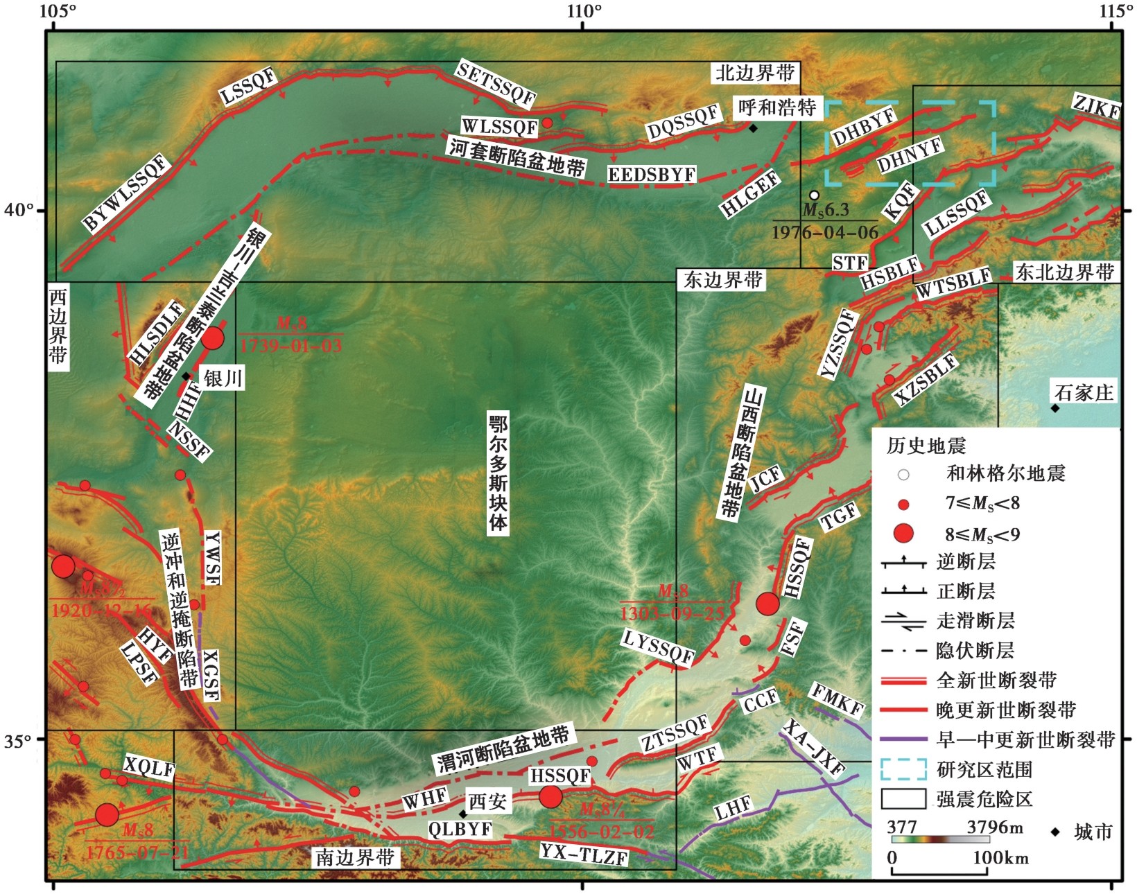
图1 鄂尔多斯块体及周边地区地震构造图(边界带划分据郑文俊等,2024a) BYWLSSQDL巴彦乌拉山山前断裂带; LSSQF狼山山前断裂带; SETSSQF色尔滕山山前断裂带; WLSSQF乌拉山山前断裂带; DQSSQF大青山山前断裂带; EEDSBYF鄂尔多斯北缘断裂带; HLGEF和林格尔断裂带; DHBYF岱海北缘断裂带; DYNYF岱海南缘断裂带; ZJKF张家口断裂带; KQF口泉断裂带; STF神头断裂带; LLSSQF六棱山山前断裂带; HSBLF衡山北麓断裂带; WTSBLF五台山北麓断裂带; YZSSQF云中山山前断裂带; TGF太谷断裂带; HSSQF霍山山前断裂带; FSF浮山断裂带; CCF陈村断裂带; XA-JXF新安-郏县断裂带; FMKF封门口断裂带; XZSBLF系舟山北麓断裂带; JCF交城断裂带; LYSSQF罗云山山前断裂带; ZTSSQF中条山山前断裂带; WTF温塘断裂带; HSSQF华山山前断裂带; WHF渭河断裂带; QLBYF秦岭北缘断裂带; LHF洛河断裂带; YX-TLZF余下-铁炉子断裂带; XQLF西秦岭断裂带; XGSF小关山断裂带; LPSF六盘山断裂带; HYF海原断裂带; YWSF云雾山断裂带; NSSF牛首山断裂带; HHF黄河断裂带; HLSDLF贺兰山东麓断裂带
Fig. 1 Seismo-tectonic map of the Ordos Block and its surrounding areas (Boundary zone division is from ZHENG Wen-jun et al., 2024a).
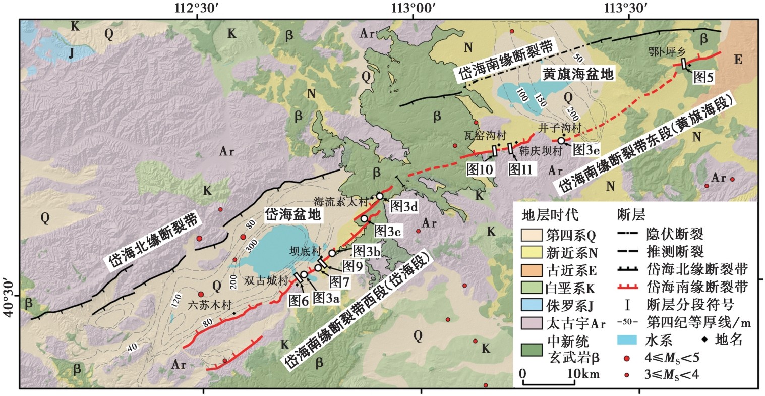
图2 岱海南缘断裂带沿线地质图
Fig. 2 Geological map along the Daihai southern margin fault zone.
| 样品编号 | 实验编号 | 东经 /(°) | 北纬 /(°) | 海拔高度 /m | 埋深 /m | 测量方法 | 年龄 /ka |
|---|---|---|---|---|---|---|---|
| SGC-OSL-1 | LED21-524 | 112.714198 | 40.518711 | 1265 | 3.0 | SMAR细颗粒石英OSL | 2.9±0.2 |
| SGC-OSL-2 | LED21-525 | 112.714198 | 40.518711 | 1265 | 4.0 | SMAR细颗粒石英OSL | 8.9±0.6 |
| SGC-OSL-3 | LED21-526 | 112.714198 | 40.518711 | 1265 | 5.0 | SMAR细颗粒石英OSL | 67.4±4.8 |
| WJY-OSL-2 | LED21-516 | 113.19041 | 40.739859 | 1393 | 5.0 | SMAR细颗粒石英OSL | 92.1±8.5 |
| WJY-OSL-3 | LED21-517 | 113.19041 | 40.739859 | 1393 | 6.0 | SMAR细颗粒石英OSL | 59.6±5.1 |
| HQB-OSL-1 | LED21-521 | 113.217957 | 40.742441 | 1397 | 1.0 | SMAR细颗粒石英OSL | 73.1±6.4 |
| HQB-OSL-2 | LED21-522 | 113.217957 | 40.742441 | 1397 | 1.5 | SMAR细颗粒石英OSL | 58.5±4.9 |
表1 样品释光测年数据
Table1 Data of the optical dating samples
| 样品编号 | 实验编号 | 东经 /(°) | 北纬 /(°) | 海拔高度 /m | 埋深 /m | 测量方法 | 年龄 /ka |
|---|---|---|---|---|---|---|---|
| SGC-OSL-1 | LED21-524 | 112.714198 | 40.518711 | 1265 | 3.0 | SMAR细颗粒石英OSL | 2.9±0.2 |
| SGC-OSL-2 | LED21-525 | 112.714198 | 40.518711 | 1265 | 4.0 | SMAR细颗粒石英OSL | 8.9±0.6 |
| SGC-OSL-3 | LED21-526 | 112.714198 | 40.518711 | 1265 | 5.0 | SMAR细颗粒石英OSL | 67.4±4.8 |
| WJY-OSL-2 | LED21-516 | 113.19041 | 40.739859 | 1393 | 5.0 | SMAR细颗粒石英OSL | 92.1±8.5 |
| WJY-OSL-3 | LED21-517 | 113.19041 | 40.739859 | 1393 | 6.0 | SMAR细颗粒石英OSL | 59.6±5.1 |
| HQB-OSL-1 | LED21-521 | 113.217957 | 40.742441 | 1397 | 1.0 | SMAR细颗粒石英OSL | 73.1±6.4 |
| HQB-OSL-2 | LED21-522 | 113.217957 | 40.742441 | 1397 | 1.5 | SMAR细颗粒石英OSL | 58.5±4.9 |
| 样品编号 | 实验编号 | 东经 /(°) | 北纬 /(°) | 海拔高度 /m | 样品 类别 | 常规放射性碳年龄 /a BP | 校正后年龄 /cal a BP |
|---|---|---|---|---|---|---|---|
| BD-1 | Beta-608765 | 112.714276 | 40.518693 | 1276 | 木炭 | 980±30 | (99.7%)960~777 |
| BD-2 | Beta-608766 | 112.714276 | 40.518693 | 1276 | 泥炭 | 2620±30 | (99.7%)2850~2542 |
表2 样品14C测年数据
Table2 Data of the 14C dating samples
| 样品编号 | 实验编号 | 东经 /(°) | 北纬 /(°) | 海拔高度 /m | 样品 类别 | 常规放射性碳年龄 /a BP | 校正后年龄 /cal a BP |
|---|---|---|---|---|---|---|---|
| BD-1 | Beta-608765 | 112.714276 | 40.518693 | 1276 | 木炭 | 980±30 | (99.7%)960~777 |
| BD-2 | Beta-608766 | 112.714276 | 40.518693 | 1276 | 泥炭 | 2620±30 | (99.7%)2850~2542 |
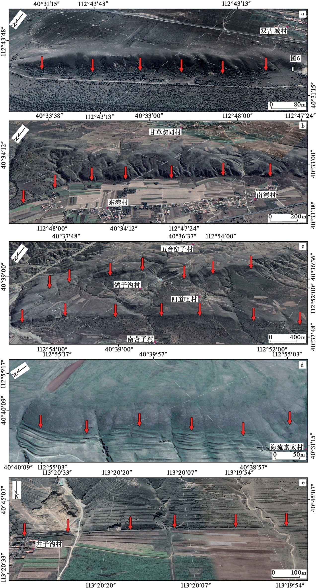
图3 Google Earth卫星影像地貌特征
Fig. 3 Geomorphic characteristics of the Google Earth satellite images.
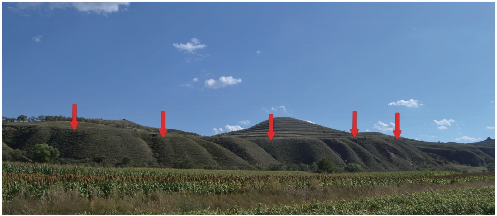
图4 海流素太村一带的地貌陡坎
Fig. 4 The physiognomy scarps near the Hailiu Sutai village area.
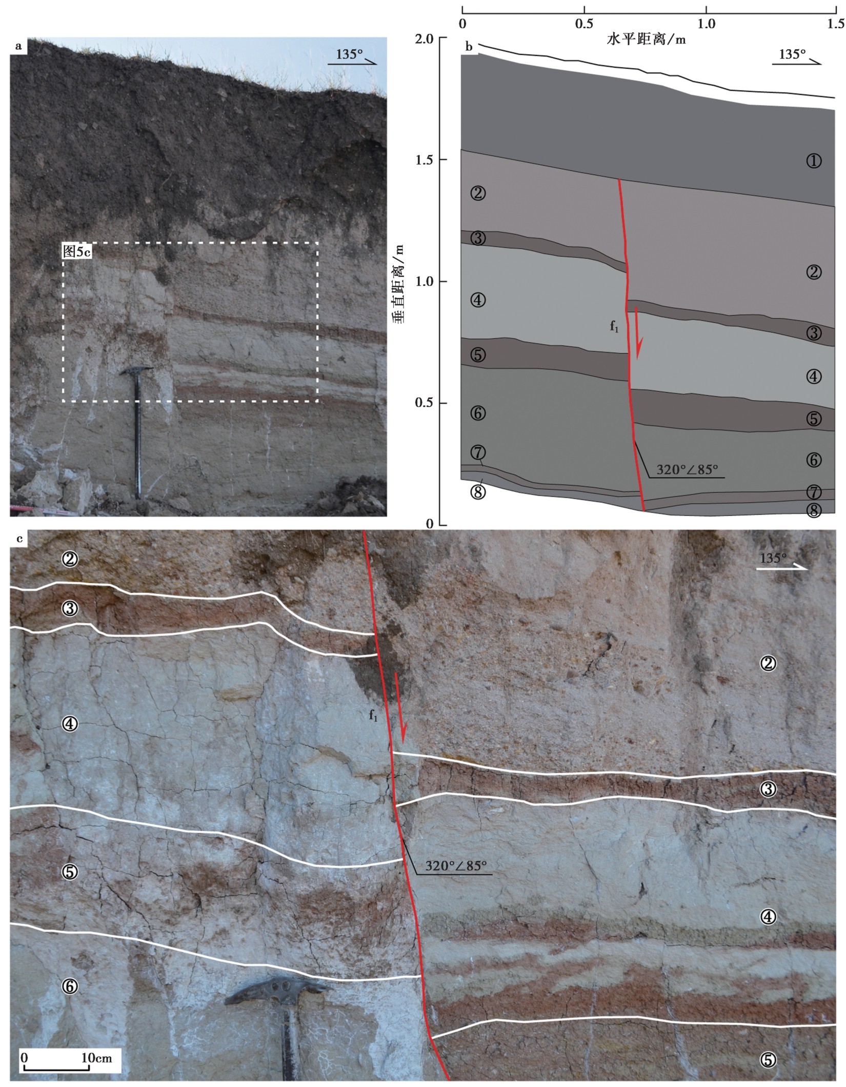
图5 鄂卜坪村断层剖面图 a剖面照片; b剖面图; c剖面局部放大图
Fig. 5 Fault profile near the Ebuping village.
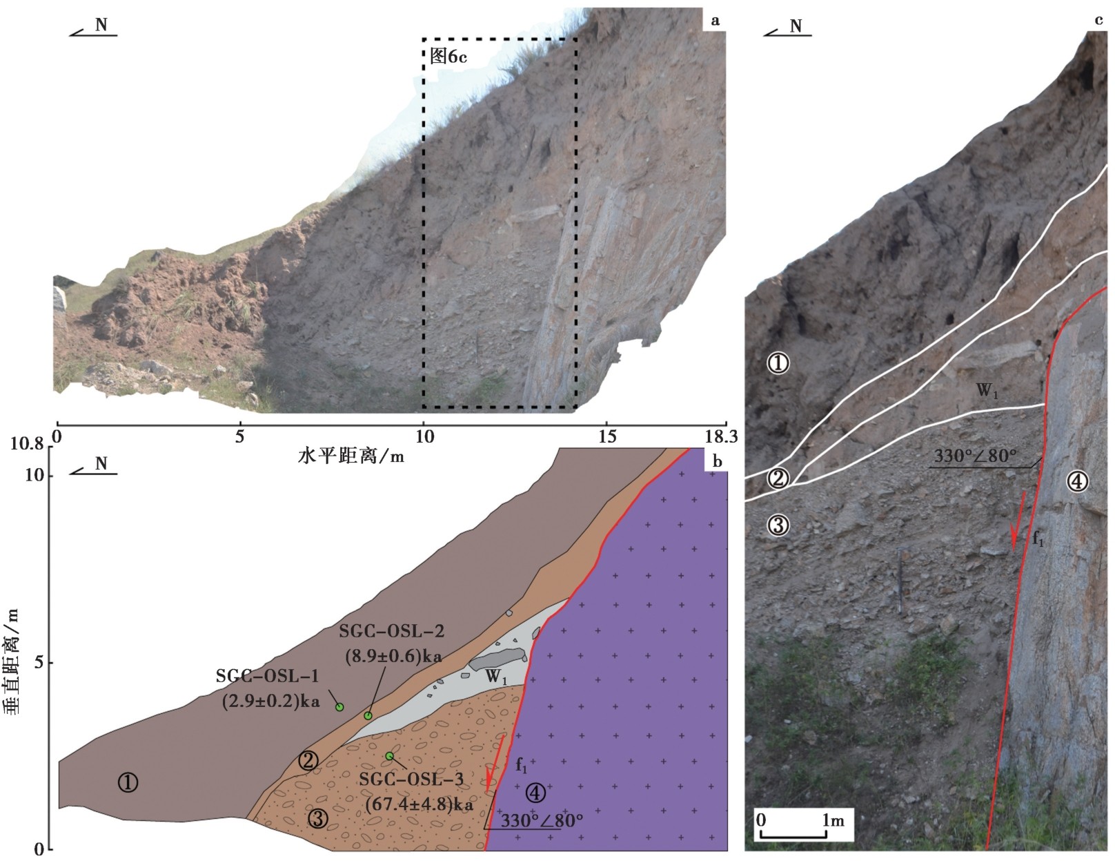
图6 双古城村断层剖面图 a剖面照片; b剖面图; c剖面局部放大图
Fig. 6 Fault profile of the Shuanggucheng village.
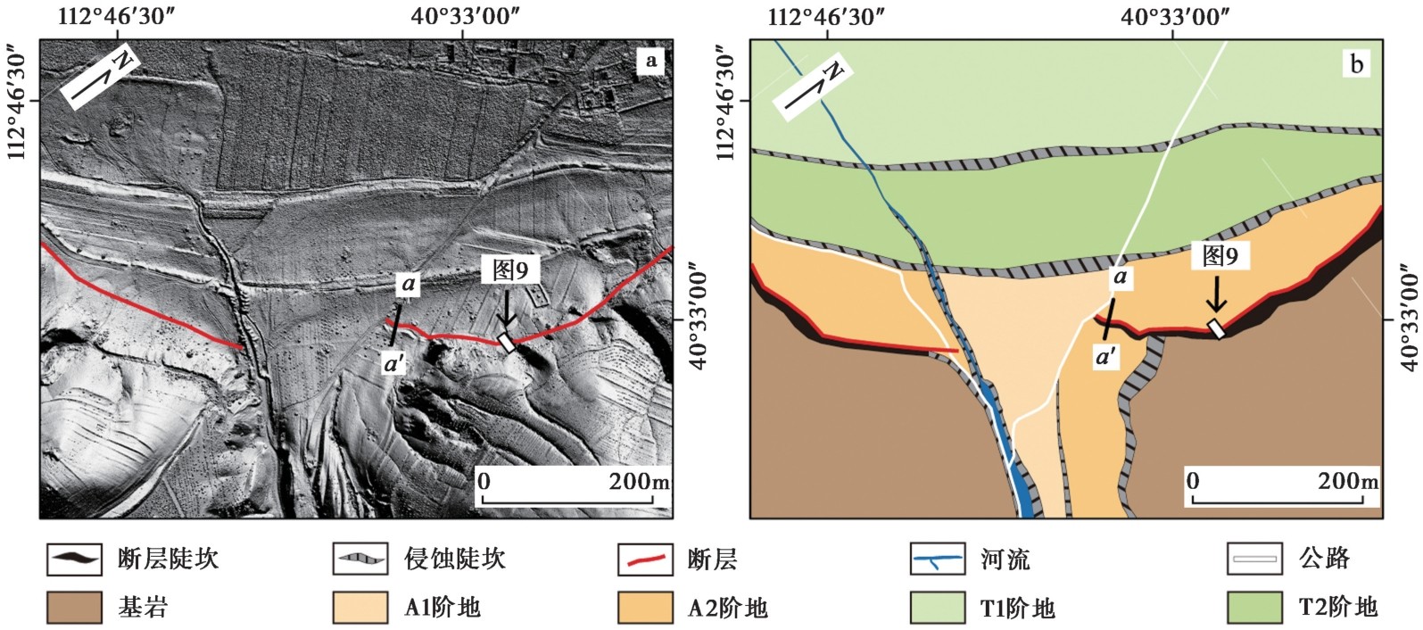
图7 坝底村地貌分类解译图
Fig. 7 Interpretation map showing the geomorphologic classification in Badi village area.
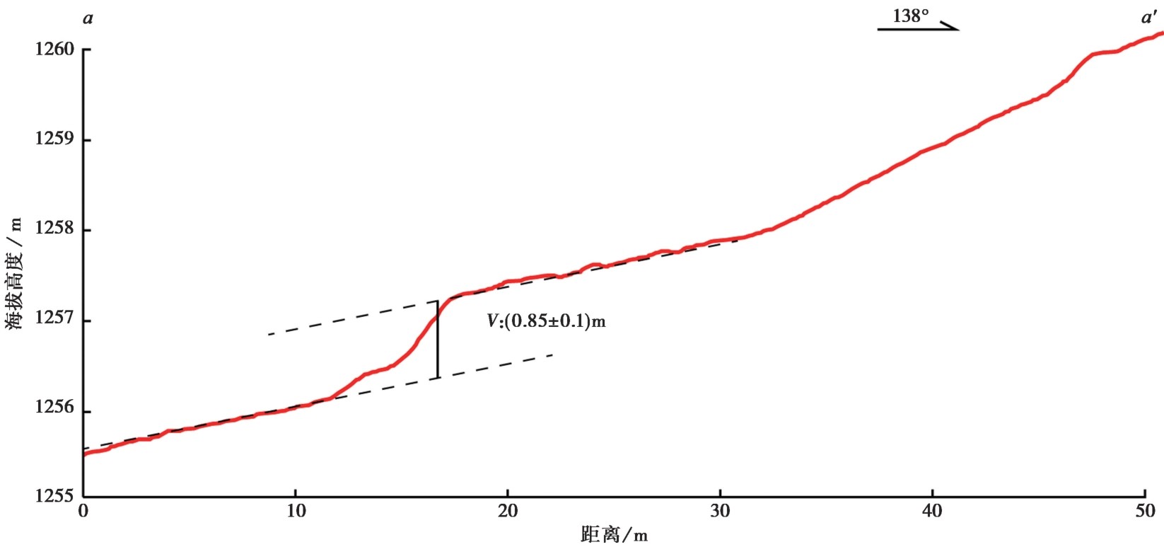
图8 坝底村aa'地形剖面图
Fig. 8 Topographic profile along aa' line near the Badi village.
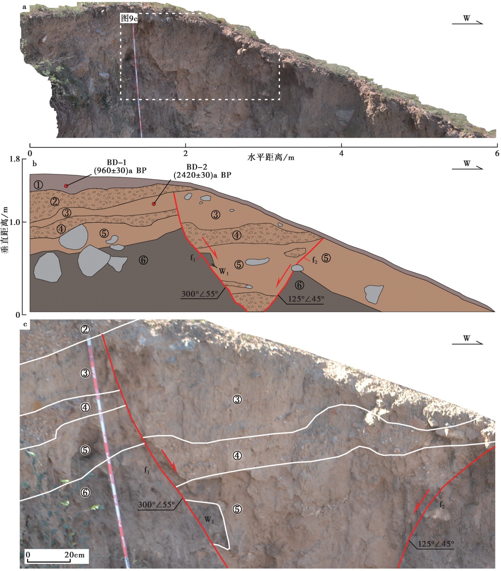
图9 坝底村断层剖面 a剖面照片; b剖面图; c剖面局部放大图
Fig. 9 Fault profile near the Badi village.
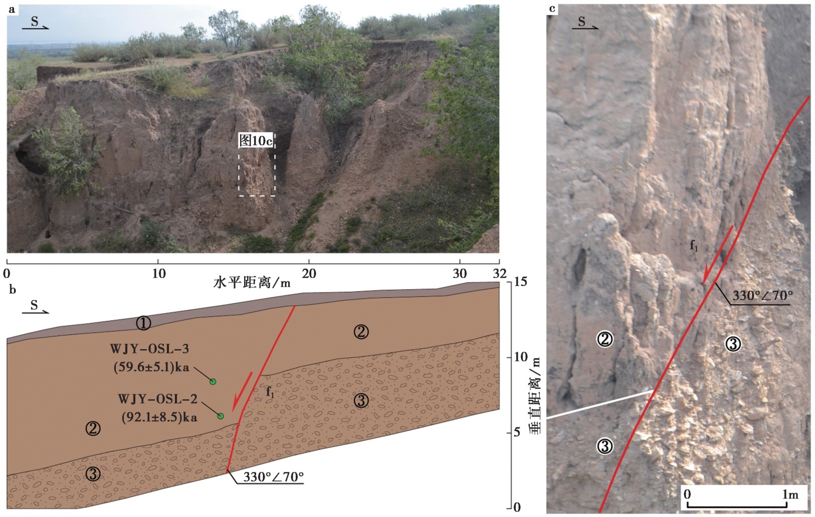
图10 瓦窑沟村断层剖面 a剖面照片; b剖面图; c剖面局部放大图
Fig. 10 Fault profile near the Wayaogou village.
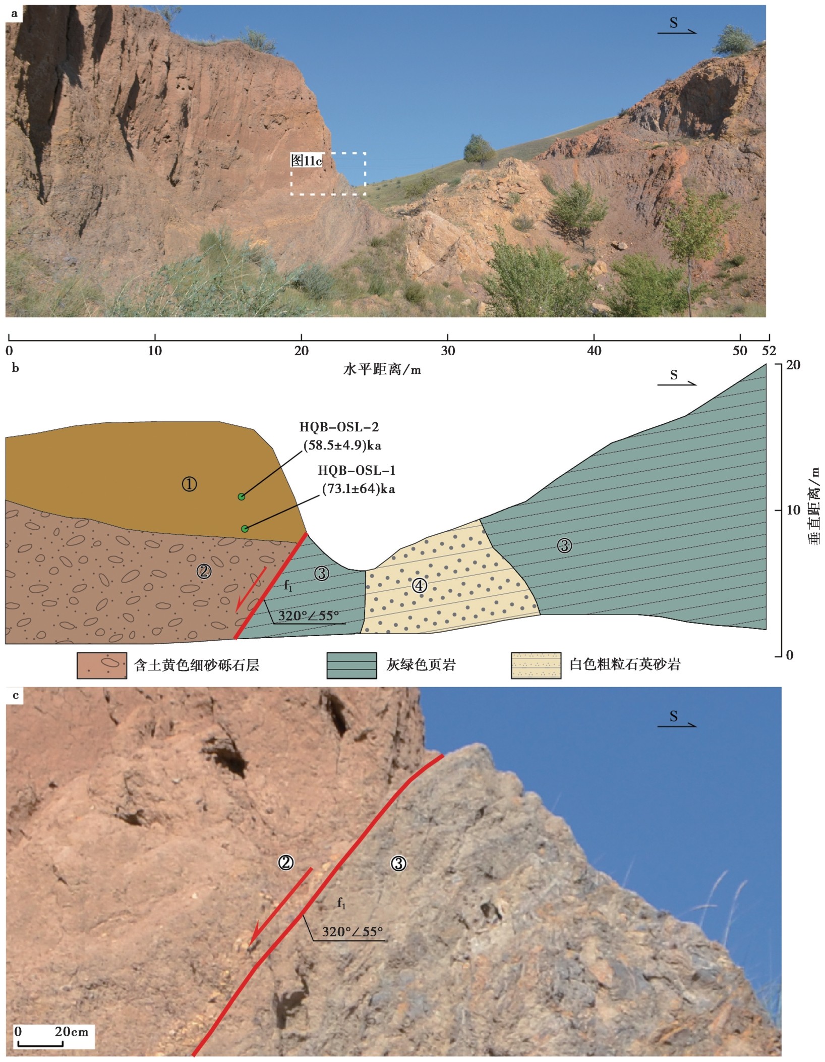
图11 韩庆坝村断层剖面 a剖面照片; b剖面图; c剖面局部放大图
Fig. 11 Fault profile near the Hanqingba village.
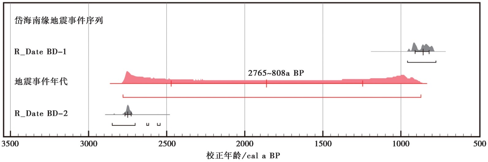
图12 坝底村探槽地震事件年代的OxCal校正结果 黑色曲线为OxCal分析后的后验分布; 红色曲线表示事件及其相关的时间范围
Fig. 12 Results of the OxCal analysis of the radiocarbon dates of the samples from the Badi village trench.
| 断裂名称 | 断裂长度/km | 经验公式 | 震级估计 |
|---|---|---|---|
| 岱海南缘断裂带西段(岱海段) | 52.8 | M=3.3+2.1log(L)(郭增建等, MW=4.86+1.32log(L)(Wells et al., MS=3.821+1.860log(L)(龙锋等, | MS6.9~7.1 |
| 岱海南缘断裂带东段(黄旗海段) | 55.6 | M=3.3+2.1log(L)(郭增建等, MW=4.86+1.32log(L)(Wells et al., MS=3.821+1.860log(L)(龙锋等, | MS7.0~7.2 |
| 岱海南缘断裂带全段 | 120 | M=3.3+2.1log(L)(郭增建等, MW=4.86+1.32log(L)(Wells et al., MS=3.821+1.860log(L)(龙锋等, | MS7.6~7.7 |
表3 岱海南缘断裂带最大震级估计
Table3 Maximum magnitude estimation of the Daihai southern margin fault zone
| 断裂名称 | 断裂长度/km | 经验公式 | 震级估计 |
|---|---|---|---|
| 岱海南缘断裂带西段(岱海段) | 52.8 | M=3.3+2.1log(L)(郭增建等, MW=4.86+1.32log(L)(Wells et al., MS=3.821+1.860log(L)(龙锋等, | MS6.9~7.1 |
| 岱海南缘断裂带东段(黄旗海段) | 55.6 | M=3.3+2.1log(L)(郭增建等, MW=4.86+1.32log(L)(Wells et al., MS=3.821+1.860log(L)(龙锋等, | MS7.0~7.2 |
| 岱海南缘断裂带全段 | 120 | M=3.3+2.1log(L)(郭增建等, MW=4.86+1.32log(L)(Wells et al., MS=3.821+1.860log(L)(龙锋等, | MS7.6~7.7 |
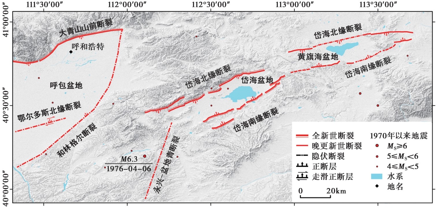
图13 岱海南缘断裂带周边震中(MS≥4)分布图
Fig. 13 Distribution of earthquakes(MS≥4)around the Daihai southern margin fault zone.
| [1] |
毕海芸, 郑文俊, 曾江源, 等. 2017. SfM摄影测量方法在活动构造定量研究中的应用[J]. 地震地质, 39(4): 656-674. doi: 10.3969/j.issn.0253-4967.2017.04.003.
|
|
DOI |
|
| [2] |
毕珉烽. 2012. 岱海断陷带活动性与地震危险性研究[D]. 北京: 中国地质大学(北京).
|
|
|
|
| [3] |
陈立春. 2002. 河套断陷带的古地震、强震复发规律和未来可能强震地点[D]. 北京: 中国地震局地质研究所.
|
|
|
|
| [4] |
陈小斌, 臧绍先, 刘永岗, 等. 2005. 鄂尔多斯地块的现今水平运动状态及其与周缘地块的相互作用[J]. 中国科学院研究生院学报, 22(3): 309-314.
|
|
DOI |
|
| [5] |
崔笃信, 郝明, 李煜航, 等. 2016. 鄂尔多斯块体周缘地区现今地壳水平运动与应变[J]. 地球物理学报, 59(10): 3646-3661.
DOI |
|
|
|
| [6] |
邓起东, 陈立春, 冉勇康. 2004. 活动构造定量研究与应用[J]. 地学前缘, 11(4): 383-392.
|
|
|
|
| [7] |
邓起东, 程绍平, 闵伟, 等. 1999. 鄂尔多斯块体新生代构造活动和动力学的讨论[J]. 地质力学学报, 5(3): 13-21.
|
|
|
|
| [8] |
邓起东, 王克鲁, 汪一鹏, 等. 1973. 山西隆起区断陷地震带地震地质条件及地震发展趋势概述[J]. 地质科学, (1): 37-47.
|
|
|
|
| [9] |
邓起东, 于贵华, 叶文华. 1992. 地震地表破裂参数与震级关系的研究[G]//国家地震局地质研究所. 活动断裂研究(2). 北京: 地震出版社: 247-264.
|
|
|
|
| [10] |
董绍鹏, 张培震, 郑文俊, 等. 2018. 河套地区狼山山前断裂的古地震研究: 构造及地震危险性启示[J]. 地震地质, 40(6): 1216-1239. doi: 10.3969/j.issn.0253-4967.2018.06.003.
|
|
DOI |
|
| [11] |
付碧宏, 时丕龙, 张之武. 2008. 四川汶川MS8.0大地震地表破裂带的遥感影像解析[J]. 地质学报, 82(12): 1679-1687.
|
|
|
|
| [12] |
高帅坡, 冉勇康, 吴富峣. 2017. 利用无人机摄影测量技术提取复杂冲积扇面构造活动信息: 以新疆巴里坤盆地南缘冲积扇面为例[J]. 地震地质, 39(4): 793-804. doi: 10.3969/j.issn.0253-4967.2017.04.013.
|
|
DOI |
|
| [13] |
顾功叙. 1983. 中国历史地震目录(公元前1831年-公元1969年)[M]. 北京: 科学出版社.
|
|
|
|
| [14] |
国家地震局“鄂尔多斯周缘活动断裂系”课题组. 1988. 鄂尔多斯周缘活动断裂系[M]. 北京: 地震出版社.
|
|
The Research Group on “Active Fault System around Ordos Massif”, State Seismological Bureau. 1988. Active Fault System Around Ordos Massif[M]. Seismological Press, Beijing (in Chinese).
|
|
| [15] |
国家地震科学数据共享中心. 1990. 1976年和林格尔6.3级地震震害及发震构造综合分析报告[R]. 北京: 国家地震局.
|
|
National Earthquake Science Data Center. 1990. Comprehensive report on earthquake damage and seismogenic structure of the 1976 MS6.3 Horinger earthquake[R]. State Seismological Bureau, Beijing (in Chinese).
|
|
| [16] |
郭增建, 秦保燕. 1979. 震源物理[M]. 北京: 地震出版社: 104-158.
|
|
|
|
| [17] | |
|
DOI |
|
| [18] |
姜大伟, 何仲太, 刘睿, 等. 2013. 岱海盆地南缘地貌陡坎的成因分析[J]. 第四纪研究, 33(3): 445-460.
|
|
|
|
| [19] |
江娃利, 肖振敏, 王焕贞, 等. 2001. 内蒙大青山山前活动断裂带的地震破裂分段特征[J]. 地震地质, 23(1): 24-34.
|
|
|
|
| [20] |
雷启云, 郑文俊, 王银, 等. 2024. 鄂尔多斯活动地块及边界带1︰50万地震构造图编制[J]. 地震科学进展, 54(1): 65-74.
|
|
|
|
| [21] |
李华章. 1979. 岱海湖盆的形成及地貌发育特征[J]. 北京师范大学学报(自然科学版), (1): 98-110.
|
|
|
|
| [22] |
李彦宝, 冉勇康, 陈立春, 等. 2015. 河套断陷带主要活动断裂最新地表破裂事件与历史大地震[J]. 地震地质, 37(1): 110-125. doi: 10.3969/j.issn.0253-4967.2015.01.009.
|
|
DOI |
|
| [23] |
刘华国, 贾启超, 龚飞. 2022. 鄂尔多斯北缘断裂托克托段晚第四纪活动特征[J]. 震灾防御技术, 17(2): 242-251.
|
|
|
|
| [24] |
刘永梅, 丁风和, 尹战军, 等. 2021. 岱海断陷带断层H2释放特征与断层活动性间的关系[J]. 地震地磁观测与研究, 42(1): 76-83.
|
|
|
|
| [25] |
龙锋, 闻学泽, 徐锡伟. 2006. 华北地区地震活断层的震级-破裂长度、破裂面积的经验关系[J]. 地震地质, 28(4): 511-535.
|
|
|
|
| [26] |
冉勇康, 邓起东. 1999. 古地震学研究的历史、现状和发展趋势[J]. 科学通报, 44(1): 12-20.
|
|
|
|
| [27] |
冉勇康, 王虎, 李彦宝, 等. 2012. 中国大陆古地震研究的关键技术与案例解析(1): 走滑活动断裂的探槽地点, 布设与事件识别标志[J]. 地震地质, 34(2): 197-210. doi: 10.3969/j.issn.0253-4967.2012.02.001.
|
|
DOI |
|
| [28] |
冉勇康, 张培震, 陈立春. 2003. 河套断陷带大青山山前断裂晚第四纪古地震完整性研究[J]. 地学前缘, 10(S1): 207-216.
|
|
|
|
| [29] |
石峰, 何宏林, 张英. 2010. 青海玉树MS7.1地震地表破裂带的遥感影像解译[J]. 震灾防御技术, 5(2): 220-227.
|
|
|
|
| [30] |
石峰, 李安, 杨晓平, 等. 2013. 甘孜-玉树断裂带东南段晚第四纪活动性研究[J]. 地震地质, 35(1): 50-63. doi: 10.3969/j.issn.0253-4967.2013.01.004.
|
|
DOI |
|
| [31] |
宋晓燕, 雷建设, 杜沫霏, 等. 2020. 鄂尔多斯地块北部及邻区Pn波速度结构与各向异性[J]. 地震学报, 42(3): 256-268.
|
|
|
|
| [32] |
王林, 何仲太, 马保起. 2008. 岱海流域地貌演化及其对断裂活动性的指示意义[J]. 第四纪研究, 28(2): 310-318.
|
|
|
|
| [33] |
魏占玉, 何宏林, 高伟, 等. 2014. 基于LiDAR数据开展活动断层填图的实验研究: 以新疆独山子背斜-逆冲断裂带为例[J]. 地震地质, 36(3): 794-813. doi: 10.3969/j.issn.0253-4967.2014.03.019.
|
|
|
|
| [34] |
姚赟胜, 王爱国, 邵延秀, 等. 2024. 大青山山前断裂土右旗西段莲花山探槽揭露的古地震事件及年龄[J]. 地震科学进展, 54(1): 34-44.
|
|
|
|
| [35] |
张晁军, 李占维, 王翠萍, 等. 2001. 1976年和林格尔6.3级地震前后震兆特征分析[J]. 地震研究, 24(3): 225-232.
|
|
|
|
| [36] |
郑文俊, 彭慧, 刘兴旺, 等. 2024a. 鄂尔多斯活动地块边界带15 000年以来强震活动与现今大地震空区[J]. 科学通报, 69(18): 2632-2647.
|
|
|
|
| [37] |
郑文俊, 孙鑫, 雷启云, 等. 2024b. 鄂尔多斯活动地块边界带第四纪晚期构造活动特征及强震孕育机制[J]. 地质力学学报, 30(2): 206-224.
|
|
|
|
| [38] |
DOI URL |
| [39] |
|
| [40] |
DOI URL |
| [41] |
DOI URL |
| [42] |
DOI URL |
| [43] |
DOI URL |
| [44] |
DOI URL |
| [45] |
|
| [46] |
DOI URL |
| [47] |
DOI URL |
| [1] | 闫成国, 王志胜, 张文朋, 胥勤勉, 高武平, 杨菲, 安立强. 天津潮白河断裂深浅部构造特征及晚第四纪活动性[J]. 地震地质, 2026, 48(5): 1231-1252. |
| [2] | 曹筠, 刘书峰, 高晨, 李彦宝, 陈杨. 阳原盆地北缘断裂全新世活动证据及其构造意义[J]. 地震地质, 2026, 48(5): 1253-1266. |
| [3] | 郭文峰, 石富强, 王霞, 宋美琴, 郝宇琦. 鄂尔多斯块体东南缘断层应力状态模拟及地震危险性分析[J]. 地震地质, 2026, 48(5): 1380-1399. |
| [4] | 程佳, 王启欣, 王子月, 徐锡伟, 蔡军涛, 徐志萍, 杨彦兵, 陈小斌, 刘巧霞. 淮安盐矿三维构造模型及其注水诱发地震机制分析[J]. 地震地质, 2026, 48(4): 959-980. |
| [5] | 刘超, 任治坤, 刘金瑞, 计昊旻, 武治群, 余思汗, 雷启云, 杜鹏. 烟筒山断裂北段全新世活动证据[J]. 地震地质, 2026, 48(3): 724-740. |
| [6] | 秦友森, 徐小波, 李彦川, 张迎峰, 连达军, 杨朝辉, 陈凯, 荣欣悦. 基于时序InSAR的海原断裂带震间形变监测[J]. 地震地质, 2025, 47(6): 1688-1707. |
| [7] | 陈倩, 张竹琪. 太原盆地地壳形变特征及其反映的强震危险性[J]. 地震地质, 2025, 47(1): 189-213. |
| [8] | 张琰, 纪志伟, 翟鸿宇, 伍纯昊. 考虑速度频散的地震动场模拟及其对地震危险性分析的意义[J]. 地震地质, 2024, 46(6): 1408-1425. |
| [9] | 孙晓, 鲁人齐, 张金玉, 王伟, 苏鹏. 川滇实验场地区活动地块边界新划分参考方案[J]. 地震地质, 2024, 46(5): 1027-1047. |
| [10] | 王雷, 任治坤, 何仲太, 计昊旻, 刘金瑞, 郭龙, 李兴奥. 天山内部那拉提断裂带全新世活动证据[J]. 地震地质, 2024, 46(4): 821-836. |
| [11] | 徐晶, 季灵运, 刘传金. 2022年泸定MS6.8地震震前区域变形背景及同震形变特征[J]. 地震地质, 2024, 46(3): 645-664. |
| [12] | 李浩峰, 徐岳仁, 郭雅丽, 刘晗, 赵昕雨, 陆玲玉, 唐嘉诚. 滇西南1976年龙陵MS7.3、MS7.4 双强震触发滑坡遥感解译及其构造意义[J]. 地震地质, 2024, 46(1): 117-140. |
| [13] | 陈鲲, 高孟潭, 俞言祥, 徐伟进, 杜义, 李雪靖, 陆东华. 融合三维断层源和二维潜在震源区的随机抽样概率地震危险性分析算法研发[J]. 地震地质, 2023, 45(2): 435-454. |
| [14] | 杨晨艺, 李晓妮, 冯希杰, 黄引弟, 裴跟弟. 秦岭北缘断裂带的重要分支——桃川-户县断层的浅部结构与第四纪活动性[J]. 地震地质, 2023, 45(2): 464-483. |
| [15] | 姜丛, 蒋长胜, 尹欣欣, 王蕊嘉, 翟鸿宇, 张延保, 来贵娟, 尹凤玲. 水力压裂诱发地震活动中的b值时空异质性及其应用[J]. 地震地质, 2022, 44(5): 1333-1349. |
| 阅读次数 | ||||||
|
全文 |
|
|||||
|
摘要 |
|
|||||